
Tokyo District Court is a district court located at 1-1-4 Kasumigaseki, Chiyoda, Tokyo, Japan.
Szymki is a village in the administrative district of Gmina Michałowo, within Białystok County, Podlaskie Voivodeship, in north-eastern Poland, close to the border with Belarus.

Anbabu is a village in the Astara Rayon of Azerbaijan. The village forms part of the municipality of Motolayataq.
Dimitrovka is a village in the Ismailli Rayon of Azerbaijan.

Burdynówka is a village in the administrative district of Gmina Złoczew, within Sieradz County, Łódź Voivodeship, in central Poland. It lies approximately 5 kilometres (3 mi) east of Złoczew, 22 km (14 mi) south of Sieradz, and 69 km (43 mi) south-west of the regional capital Łódź.
Chociw is a village in the administrative district of Gmina Czerniewice, within Tomaszów Mazowiecki County, Łódź Voivodeship, in central Poland. It lies approximately 8 kilometres (5 mi) east of Czerniewice, 25 km (16 mi) north-east of Tomaszów Mazowiecki, and 56 km (35 mi) east of the regional capital Łódź.
Głuchów-Lasy is a village in the administrative district of Gmina Raków, within Kielce County, Świętokrzyskie Voivodeship, in south-central Poland. It lies approximately 9 kilometres (6 mi) west of Raków and 32 km (20 mi) south-east of the regional capital Kielce.
Dąbrówki is a village in the administrative district of Gmina Krasocin, within Włoszczowa County, Świętokrzyskie Voivodeship, in south-central Poland. It lies approximately 10 kilometres (6 mi) north of Krasocin, 15 km (9 mi) north-east of Włoszczowa, and 40 km (25 mi) west of the regional capital Kielce.
Feliksowo is a settlement in the administrative district of Gmina Stupsk, within Mława County, Masovian Voivodeship, in east-central Poland.
Boryty is a village in the administrative district of Gmina Sępopol, within Bartoszyce County, Warmian-Masurian Voivodeship, in northern Poland, close to the border with the Kaliningrad Oblast of Russia.
Buszynko Pierwsze is a settlement in the administrative district of Gmina Bobolice, within Koszalin County, West Pomeranian Voivodeship, in north-western Poland. It lies approximately 6 kilometres (4 mi) north-east of Bobolice, 39 km (24 mi) south-east of Koszalin, and 150 km (93 mi) north-east of the regional capital Szczecin.
Světice is a village and municipality in Prague-East District in the Central Bohemian Region of the Czech Republic.

Donja Jajina is a village in the municipality of Leskovac, Serbia. According to the 2002 census, the village has a population of 1338 people.
Žižavica is a village in the municipality of Leskovac, Serbia. According to the 2002 census, the village has a population of 189 people.

Suhača is a village in the municipality of Livno, Bosnia and Herzegovina.
Mustajõe is a village in Põlva Parish, Põlva County in southeastern Estonia.
Nehorići is a village in the municipality of Sokolac, Bosnia and Herzegovina.
Brezovica is a village in the municipality of Trstenik, Serbia. According to the 2002 census, the village has a population of 636 people.

Lake Onnetō (オンネトー), from the Ainu onne (ancient) and to (lake), is a freshwater lake near Ashoro in Akan National Park, Hokkaidō, Japan.
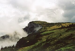
The Bistrița Mountains are mountain ranges in northern central Romania.


