Related Research Articles

Stratigraphy is a branch of geology concerned with the study of rock layers (strata) and layering (stratification). It is primarily used in the study of sedimentary and layered volcanic rocks. Stratigraphy has three related subfields: lithostratigraphy, biostratigraphy, and chronostratigraphy.

Biostratigraphy is the branch of stratigraphy which focuses on correlating and assigning relative ages of rock strata by using the fossil assemblages contained within them. The primary objective of biostratigraphy is correlation, demonstrating that a particular horizon in one geological section represents the same period of time as another horizon at a different section. Fossils within these strata are useful because sediments of the same age can look completely different, due to local variations in the sedimentary environment. For example, one section might have been made up of clays and marls, while another has more chalky limestones. However, if the fossil species recorded are similar, the two sediments are likely to have been laid down around the same time. Ideally these fossils are used to help identify biozones, as they make up the basic biostratigraphy units, and define geological time periods based upon the fossil species found within each section.
A geological formation, or simply formation, is a body of rock having a consistent set of physical characteristics (lithology) that distinguishes it from adjacent bodies of rock, and which occupies a particular position in the layers of rock exposed in a geographical region. It is the fundamental unit of lithostratigraphy, the study of strata or rock layers.
A stratigraphic unit is a volume of rock of identifiable origin and relative age range that is defined by the distinctive and dominant, easily mapped and recognizable petrographic, lithologic or paleontologic features (facies) that characterize it.
Lithostratigraphy is a sub-discipline of stratigraphy, the geological science associated with the study of strata or rock layers. Major focuses include geochronology, comparative geology, and petrology.
Chronostratigraphy is the branch of stratigraphy that studies the ages of rock strata in relation to time.

The Chinle Formation is an Upper Triassic continental geological formation of fluvial, lacustrine, and palustrine to eolian deposits spread across the U.S. states of Nevada, Utah, northern Arizona, western New Mexico, and western Colorado. In New Mexico, it is often raised to the status of a geological group, the Chinle Group. Some authors have controversially considered the Chinle to be synonymous to the Dockum Group of eastern Colorado and New Mexico, western Texas, the Oklahoma panhandle, and southwestern Kansas. The Chinle Formation is part of the Colorado Plateau, Basin and Range, and the southern section of the Interior Plains. A probable separate depositional basin within the Chinle is found in northwestern Colorado and northeastern Utah. The southern portion of the Chinle reaches a maximum thickness of a little over 520 meters (1,710 ft). Typically, the Chinle rests unconformably on the Moenkopi Formation.

In biostratigraphy, biostratigraphic units or biozones are intervals of geological strata that are defined on the basis of their characteristic fossil taxa, as opposed to a lithostratigraphic unit which is defined by the lithological properties of the surrounding rock.

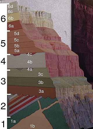
In geology, a bed is a layer of sediment, sedimentary rock, or volcanic rock "bounded above and below by more or less well-defined bedding surfaces". A bedding surface is three-dimensional surface, planar or curved, that visibly separates each successive bed from the preceding or following bed. Where bedding surfaces occur as cross-sections, e.g., in a 2-dimensional vertical cliff face of horizontal strata, are often referred to as bedding contacts. Within conformable successions, each bedding surface acted as the depositional surface for the accumulation of younger sediment.
A stratigraphic section is a sequence of layers of rocks in the order they were deposited. It is based on the principle of original horizontality, which states that layers of sediment are originally deposited horizontally under the action of gravity.
In paleontology, biochronology is the correlation in time of biological events using fossils. In its strict sense, it refers to the use of assemblages of fossils that are not tied to stratigraphic sections. Collections of land mammal ages have been defined for every continent except Antarctica, and most are correlated with each other indirectly through known evolutionary lineages. A combination of argon–argon dating and magnetic stratigraphy allows a direct temporal comparison of terrestrial events with climate variations and mass extinctions.
A system in stratigraphy is a sequence of strata that were laid down together within the same corresponding geological period. The associated period is a chronological time unit, a part of the geological time scale, while the system is a unit of chronostratigraphy. Systems are unrelated to lithostratigraphy, which subdivides rock layers on their lithology. Systems are subdivisions of erathems and are themselves divided into series and stages.
In stratigraphy and geology, an eonothem is the totality of rock strata laid down in the stratigraphic record deposited during a certain eon of the continuous geologic timescale. The eonothem is not to be confused with the eon itself, which is a corresponding division of geologic time spanning a specific number of years, during which rocks were formed that are classified within the eonothem. Eonothems have the same names as their corresponding eons, which means during the history of the Earth only four eonothems were formed. Oldest to newest these are the Hadean, Archean, Proterozoic, and Phanerozoic. A rock stratum, fossil or feature present in the "upper Phanerozoic" eonothem would therefore have originated within the "later Phanerozoic" eon. In practice, the rock column is discontinuous:
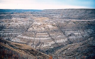
Technically, a complete geologic record doesn't occur anywhere. For such a record to develop would require the area to have been receiving sedimentary deposits continually ever since the origin of the earth. Nowhere is such a situation known to exist. If it did exist, we could not effectively look at the strata because they would still be buried, and modern strata would continue to be deposited on top of them. The earth's surface has been far too dynamic to allow that to occur anywhere. No area has been in such a static condition throughout the earth's long history. Areas that have had sediment deposited on them at one time are later uplifted and eroded. In some places this has occurred many times. There is ample evidence to prove such a sequence of events.
Magnetostratigraphy is a geophysical correlation technique used to date sedimentary and volcanic sequences. The method works by collecting oriented samples at measured intervals throughout the section. The samples are analyzed to determine their characteristic remanent magnetization (ChRM), that is, the polarity of Earth's magnetic field at the time a stratum was deposited. This is possible because volcanic flows acquire a thermoremanent magnetization and sediments acquire a depositional remanent magnetization, both of which reflect the direction of the Earth's field at the time of formation. This technique is typically used to date sequences that generally lack fossils or interbedded igneous rock. It is particularly useful in high-resolution correlation of deep marine stratigraphy where it allowed the validation of the Vine–Matthews–Morley hypothesis related to the theory of plate tectonics.
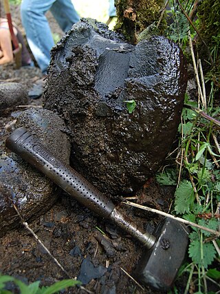
The Alum Shale Formation is a formation of black shale of Miaolingian to Tremadocian in age found predominantly in southern Scandinavia. It is shale or clay slate containing pyrite. Decomposition of pyrite by weathering forms sulfuric acid, which acts on potash and alumina constituents to form alum, which often occurs as efflorescences on the rock outcrop.
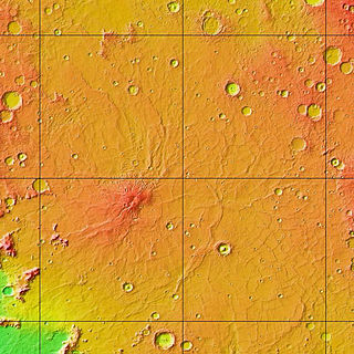
The Hesperian is a geologic system and time period on the planet Mars characterized by widespread volcanic activity and catastrophic flooding that carved immense outflow channels across the surface. The Hesperian is an intermediate and transitional period of Martian history. During the Hesperian, Mars changed from the wetter and perhaps warmer world of the Noachian to the dry, cold, and dusty planet seen today. The absolute age of the Hesperian Period is uncertain. The beginning of the period followed the end of the Late Heavy Bombardment and probably corresponds to the start of the lunar Late Imbrian period, around 3700 million years ago (Mya). The end of the Hesperian Period is much more uncertain and could range anywhere from 3200 to 2000 Mya, with 3000 Mya being frequently cited. The Hesperian Period is roughly coincident with the Earth's early Archean Eon.

The Munising Group or Formation is a 1,700 feet (520 m) thick, white to light grey Cambrian sedimentary unit that crops out in Michigan and Ontario. At one end of its extent, it comprises a basal conglomerate overlain by the Chapel Rock Member and the Miners Castle Member; elsewhere, it comprises the Eau Claire, Galesville (=Dresbach), and Franconia Members. Anhydritic evaporite deposits are present in places. The conglomerate was deposited by rivers in flood, with the Chapel Rock member, which contains deltaic deposits, representing transgression as the conglomerate cones became submerged; the Miners Castle member was deposited further from the shoreline, representing shelf deposits. Its uppermost strata may be Early Ordovician in age, and contain conodonts, trilobites and phosphatic moulds of brachiopods, ostrocoderm fish and gastropods.
The Maquoketa Formation is a geologic formation in Illinois, Indiana. Iowa, Kansas, Minnesota, Missouri, and Wisconsin. It preserves mollusk, coral, brachiopod and graptolite fossils dating back to the Darriwilian to Hirnantian stages of the Ordovician period.
The Mount Whyte Formation is a stratigraphic unit that is present on the western edge of the Western Canada Sedimentary Basin in the southern Canadian Rockies and the adjacent southwestern Alberta plains. It was deposited during Middle Cambrian time and consists of shale interbedded with other siliciclastic rock types and limestones. It was named for Mount Whyte in Banff National Park by Charles Doolittle Walcott, the discoverer of the Burgess shale fossils, and it includes several genera of fossil trilobites.
Valdar Jaanusson was an Estonian-Swedish geologist. In 1960, he introduced the concept of topostratigraphy into Swedish stratigraphy. A recognized expert on the geology of the Ordovician period, he was member of the Estonian Academy of Sciences.
References
- 1 2 3 4 Kumpulainen, Risto A (2016). Kumpulainen, Risto A. (ed.). "Guide for geological nomenclature in Sweden" (PDF). GFF . 139: 3–20. doi: 10.1080/11035897.2016.1178666 .
- 1 2 3 Lundqvist, Jan; Lundqvist, Thomas; Lindström, Maurits; Calner, Mikael; Sivhed, Ulf (2011). "Stratigrafisk terminologi". Sveriges Geologi: Från urtid till nutid (in Swedish) (3rd ed.). Spain: Studentlitteratur. pp. 321–322. ISBN 978-91-44-05847-4.
| | This article about stratigraphy is a stub. You can help Wikipedia by expanding it. |