Khagaria is a town in Indian state of Bihar and the administrative headquarters of Khagaria district. Khagaria is a part of Munger division. It is located at 25.5°N 86.48°E and has an average elevation of 36 metres. The Khagaria Junction railway station serves the town. It is situated about 25 km north of Munger.
Thiruneermalai is a neighborhood in the city of Tambaram, situated within the Chennai Metropolitan Area, Tamil Nadu, India.

Khetri Nagar is a town in the Neem Ka Thana district of Rajasthan in India. It is a part of the Shekhawati region. Khetri consists of two towns, "Khetri Town," founded by Raja Raja Bhopal Singh Ji, and "Khetri Nagar," which is about 10 km away from Khetri. Khetri Nagar, well known for its Copper Project, was built by and is under the control of Hindustan Copper Limited, a public sector undertaking under the Government of India. Khetri Nagar is also known as "Copper." There are many attached villages near Khetri Nagar, such as Manota Khurd; the people of this village were employed in mines.

Jhunjhunu district is a district of the Indian state of Rajasthan in northern India. The city of Jhunjhunu is the district headquarters. Jhunjhunu is an old and historical town having its own district headquarters. It is said that it was ruled over by Chouhan dynasty in the Vikram era 1045. The district is famous for the frescos on its grand Havelis. It is also famous for providing considerable representation to Indian defense forces. Jhunjhunu district was named in the memory of a Jat named "Jhunjha" or "Jujhar Singh Nehra". The district has a population of 2,139,658, an area of 5926 km², and a population density of 361 persons per km. The district falls within Shekhawati region, and is bounded on the North-East and East by Haryana state, on the South-East, South & South-West by Sikar District & on the North-West and North by Churu District.

Gopalganj is a town, municipality and headquarters of Gopalganj district in the Indian state of Bihar.

Chomu is a town and municipality, near the city of Jaipur in Jaipur district in the state of Rajasthan, India.
Dhampur is a city and a municipal board in Bijnor district in the state of Uttar Pradesh, India. It is located at 29.51°N 78.50°E, and lies in Northern India.
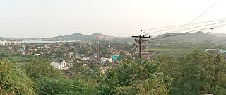
Kamakhyanagar is a town (NAC) and a subdivision in Dhenkanal district in the Indian state of Odisha. It is located 37 km north of Dhenkanal.

Kotputli is a city and municipal council in Kotputli-Behror district of Rajasthan, India, located between Jaipur city and New Delhi. On 17 March 2023 it was made one of the two headquarters of the newly created Kotputli Behror district.
Nambol is a Town of Manipur, India. It Stretches across one of the major heartline of Highway Known as Tiddim Road.The General functionalities are under administration of Nambol municipal council Most part of Nambol comes under Bishnupur district, While some parts of Nambol belongs to Imphal west District. Nambol as a whole is known to be a Sub- Division. Nambol is one of the educational hubs of Bishnupur district as well as of Manipur. Its market, known as Nambol Bazaar is the second most busiest market, after Khwairamband Bazaar( also known as 'IMA market' ) in Manipur.

Narsingi is an Indian satellite town of Hyderabad in Ranga Reddy district of Telangana state. It is in the administrative headquarters of Gandipet mandal. Several high rise residential towers like My Home Avatar, PWS 7 Hills etc. are located in Narsingi. The Outer Ring Road, Hyderabad has a junction there.

Neem Ka Thana is a city and administrative headquarter of Neem Ka Thana district located 73 km from Sikar City in the Dhundhar region in the Rajasthan state of India. Sikar, Khandela, Sri Madhopur, Kotputli, Khetri, and Narnaul are some major cities and towns near Neem Ka Thana. It is located at a distance of 119 kilometers from Jaipur and 241 kilometers from Delhi. Neem Ka Thana is well connected with others cities in the region with roads and Indian Railways.
Old Malda is a census town in Malda district in the Indian state of West Bengal. It is a part of the Malda Metropolitan Area. It is located on the eastern bank of the river Mahananda.
Samurou is a town and a Municipal Council in Imphal West district in the Indian state of Manipur. The town is about 13 kilometres from Imphal via Mayai Lambi Road and is on the banks of Imphal River
Sarai Mir is a town and a nagar panchayat in Azamgarh district in the Indian state of Uttar Pradesh.
Jafarabad is a town and nagar panchayat in Jaunpur district in the Indian state of Uttar Pradesh.
Tentha is a village in Thoubal District in Manipur, India.

Dhosi is a village in Khetri subdistrict, Neem Ka Thana district, Rajasthan, India.

Thongju (Vidhan Sabha constituency) is one of the 60 Vidhan Sabha constituencies in the Indian state of Manipur.
Wangoo is a village in the Kakching district of the Indian state of Manipur. It is situated approximately 64 km south of the state capital, Imphal. It has an area of 13.05 km2 with a population of 6134.

