West Cape Howe National Park is a national park in Western Australia, 390 kilometres (240 mi) southeast of Perth. The park is found between Albany and Denmark within the City of Albany and in the Great Southern region.

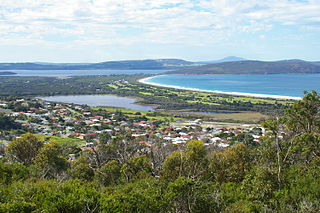
The City of Albany is a local government area in the Great Southern region of Western Australia, about 410 kilometres (255 mi) south-southeast of Perth, the capital of Western Australia. It covers an area of 4,312.3 square kilometres (1,665 sq mi), including the Greater Albany metropolitan area and the Port of Albany, as well as the surrounding agricultural district and some national parks. The City of Albany had a population of over 36,000 at the 2016 census.
Milpara is a north-western suburb of Albany in southern Western Australia. Its local government area is the City of Albany. The western boundary of the suburb is formed by the Albany Highway.
Bornholm is a locality of the City of Albany in the Great Southern region of Western Australia. The coastal region of the locality, facing the Southern Ocean, is covered by the West Cape Howe National Park. It is located between Albany and Denmark on the Lower Denmark Road.

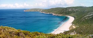
West Cape Howe is a coastal headland near Albany, Western Australia that forms the westernmost extent of the Great Australian Bight, and is therefore the southernmost point in Western Australia and in all of Australia west of the 136th meridian east.
Meerup is a rural locality of the Shire of Manjimup in the South West region of Western Australia, on the coastline of the Southern Ocean. The south-western part of the locality, along the coastline, is completely covered by the D'Entrecasteaux National Park with the western section of the Boorara-Gardner National Park bordering the former. In the north, parts of the Greater Hawke National Park are located within Meerup. The Meerup River forms the northern locality's border, near the coast.
The suburb of Albany is the central business district of the City of Albany in the Great Southern region of Western Australia. The suburb is bounded by the Princess Royal Harbour to the south. The southern terminus of the Albany Highway is located within the suburb, at York Street.

Port Albany is a suburb of the City of Albany in the Great Southern region of Western Australia. The suburb is bounded by the Princess Royal Harbour to the south and King George Sound to the east and is home to the Port of Albany. To the south of Port Albany, the Ataturk Channel, which connects Princess Royal Harbour with King George Sound, separates it from Vancouver Peninsula.
Seppings is a suburb of the City of Albany in the Great Southern region of Western Australia. The suburb is bounded by the King George Sound to the east and home to Lake Seppings and surrounding wetlands. It also contains the south-western half of the Albany Golf Course. Only the area along the northern border of the suburb and a stretch along Middleton Beach are built up with houses.

Youngs Siding is a town and locality of the City of Albany in the Great Southern region of Western Australia. It borders the Wilson Inlet to the west and the South Coast Highway runs through the locality west to east.
Marbelup is a townsite and locality of the City of Albany in the Great Southern region of Western Australia. The South Coast Highway runs through the locality west to east while the Great Southern Railway passes through it from north to south. The Marbelup Nature Reserve surrounds the remaining gazetted townsite, just 4,052 square metres (43,620 sq ft) in size, on three sides but no town actually exists at location.
Lowlands is a locality of the City of Albany in the Great Southern region of Western Australia, located along the Southern Ocean. It is located west of the West Cape Howe National Park, and south east of Wilson Inlet.

Nullaki is a locality of the City of Albany in the Great Southern region of Western Australia. It is located on a peninsula, between the Southern Ocean in the south and the Wilson Inlet to the north, with the latter intermittently connecting to the former west of Nullaki Point.
West Cape Howe is a locality of the City of Albany in the Great Southern region of Western Australia. The locality of West Cape Howe is on a headland, the West Cape Howe, and surrounded on three sides by the Southern Ocean. It is entirely covered by the West Cape Howe National Park, which also extends into the neighbouring Bornholm and Kronkup. Torbay Head, located within West Cape Howe, is the southernmost point in Western Australia.

Torndirrup is a locality of the City of Albany in the Great Southern region of Western Australia. Torndirrup is on a peninsula of the same name and surrounded on three sides by water, with the Southern Ocean in the south and east and the King George Sound in the north-east. It also borders Princess Royal Harbour in the north-west. The entirety of Torndirrup National Park is located within Torndirrup and only small sections of the locality are not part of the national park.
Millbrook is a locality of the City of Albany in the Great Southern region of Western Australia. The King River forms the south-western border of the locality. The Mill Brook runs through the locality from north to south before flowing into the King River at its southern border. The Mill Brook Nature Reserve however is located further upstream, in the locality of Green Valley.
Walmsley is a locality of the City of Albany in the Great Southern region of Western Australia. Chester Pass Road forms the western boundary of Walmsley.
Redmond West is a rural locality of the City of Albany in the Great Southern region of Western Australia. The north-western corner of the locality is taken up by the south-eastern section of the Mount Lindesay National Park and the Blue Gum Creek Nature Reserve is also located within Redmond West. The Hay River passes through it and also forms its boundary in the south-west.
Palmdale is a rural locality of the City of Albany in the Great Southern region of Western Australia. The Kalgan River forms the western boundary of the locality, with the Granite Hill Nature Reserve stretching along the river in the north of Palmdale.

Nanarup is a rural locality of the City of Albany in the Great Southern region of Western Australia, located along the Southern Ocean. The far west of the locality is taken up by parts of Gull Rock National Park while the eastern half of Nanarup is taken up by the Two Peoples Bay Nature Reserve. In between the two lies Taylor Inlet and Nanarup Beach.


