
Oshawa is a city in Ontario, Canada, on the Lake Ontario shoreline. It lies in Southern Ontario, approximately 60 km (37 mi) east of Downtown Toronto. It is commonly viewed as the eastern anchor of the Greater Toronto Area and of the Golden Horseshoe. It is the largest municipality in the Regional Municipality of Durham. The name Oshawa originates from the Ojibwa term aazhawe, meaning "the crossing place" or just "a cross".

Clarington is a lower-tier municipality in the Regional Municipality of Durham in Ontario, Canada. It was incorporated in 1973 as the town of Newcastle with the merging of the town of Bowmanville, the Village of Newcastle and the townships of Clarke and Darlington, and was established on January 1 1974. In 1993, the town was renamed Clarington, a blending of the names of the two former townships. Darlington today is largely suburban, while Clarke remains largely rural. Bowmanville is the largest community in the municipality and is the home of the municipal offices.

The Regional Municipality of Durham, informally referred to as Durham Region, is a regional municipality in Southern Ontario, Canada. Located east of Toronto and the Regional Municipality of York, it forms the east end of the Greater Toronto Area (GTA) and is part of the Golden Horseshoe region. It has an area of approximately 2,500 km2 (970 sq mi). The regional government is headquartered in Whitby.
Bowmanville is a town of approximately 40,000 people located in the Municipality of Clarington, Durham Region, Ontario, Canada. It is approximately 75 km (47 mi) east of Toronto, and 15 km (9.3 mi) east of Oshawa along Highway 2. Bowmanville was first incorporated as a town in 1858, but later incorporated with the neighbouring townships of Clarke and Darlington in 1974 forming the Town of Newcastle, which was renamed in 1994 to the Municipality of Clarington. Bowmanville is part of the Greater Toronto Area.

King's Highway 2, commonly referred to as Highway 2, is the lowest-numbered provincially maintained highway in the Canadian province of Ontario, and was originally part of a series of identically numbered highways which started in Windsor, stretched through Quebec and New Brunswick, and ended in Halifax, Nova Scotia. Prior to the 1990s, Highway 2 travelled through many of the major cities in Southern Ontario, including Windsor, Chatham, London, Brantford, Hamilton, Burlington, Mississauga, Toronto, Oshawa, Belleville, Kingston and Cornwall, and many other smaller towns and communities.
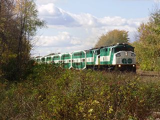
Lakeshore East is one of the seven commuter rail lines of GO Transit in the Greater Toronto Area, Ontario, Canada. It extends from Union Station in Toronto to Oshawa GO in Durham Region. Buses from Oshawa connect to communities further east in Newcastle, Bowmanville and Peterborough.
The Toronto Suburban Railway was a Canadian electric railway operator with local routes in west Toronto, and a radial (interurban) route to Guelph.

Kingston Road is a major historic arterial road in Toronto and Durham Region, Ontario. It is the southernmost major (mainly) east-west road in the eastern portion of Toronto, specifically in the district of Scarborough, and runs east to Ajax in Durham. Due to its diagonal course near the shore of Lake Ontario, the street is the terminus of many arterial roads in eastern Toronto, both east–west and north-south, with a few continuing for a short distance after as minor residential streets. However Lawrence Avenue continues as a major arterial for a considerable distance beyond it.

Durham Region Transit (DRT) is the regional public transit operator in Durham Region, Ontario, Canada, east of Toronto. Its headquarters are at 110 Westney Road South in Ajax, Ontario, and there are regional centres in Ajax, Whitby, and Oshawa. DRT was formed by the merger of Ajax/Pickering Transit, Whitby Transit, Oshawa Transit, and Clarington Transit on January 1, 2006.

Pickering GO Station is a train and bus station in the GO Transit network located in Pickering, Ontario, Canada. It is a stop on the Lakeshore East line and was the eastern terminus from 1967 until 1990, when service was extended to Whitby and subsequently to Oshawa.

Whitby GO Station is a train and bus station in the GO Transit network in Whitby, Ontario, Canada. It is a stop on the Lakeshore East line and was the eastern terminus of the dedicated GO Transit right-of-way until those tracks were extended to Oshawa in 1995. There are connections by local Durham Region Transit routes within Whitby and Durham Region.

Durham College Oshawa GO station is a station for commuter rail, passenger rail and regional bus services in Oshawa, Ontario, Canada. It is the terminal station for the Lakeshore East line of GO Transit and serves Via Rail's Corridor service, which travels from Toronto to both Ottawa and Montreal. The bus terminal is served by bus routes of GO Transit and Durham Region Transit.

Courtice is a community in Ontario, Canada, about 60 km (37 mi) east of Toronto, within the Municipality of Clarington. Adjacent to Oshawa, it is west of Bowmanville, which is also part of Clarington. Courtice Road connects with Highway 401 at Interchange 425, providing arterial access to the community. Darlington Provincial Park is located just south of Courtice.
The Midland Railway of Canada was a historical Canadian railway which ran from Port Hope, Ontario to Midland on Georgian Bay. The line was originally intended to run to Peterborough, but the competing Cobourg and Peterborough Railway was completed in 1854 and the owner's plans changed. Redirecting the line northward, it opened as the Port Hope, Lindsay & Beaverton Railway, a much longer line than originally planned. A further expansion launched in 1869 pushed the line westward towards Georgian Bay, and prompted renaming as the Midland Railway.
King's Highway 412, or simply Highway 412, is a controlled-access highway and former tolled highway in the Canadian province of Ontario. The route is 8.9 km (5.5 mi) long, connecting Highway 401 with the eastern extension of Highway 407. The route lies entirely within Whitby in the Regional Municipality of Durham, travelling within one kilometre of the border between Whitby and Ajax and Pickering.
GO Transit is an interregional public transit system in Southern Ontario, Canada, operated by the provincial crown agency Metrolinx. It primarily serves the conurbation referred to by Metrolinx as the "Greater Toronto and Hamilton Area" (GTHA) with operations extending to several communities in the area centred around Toronto and Hamilton.
Canadian National Railway's Kingston Subdivision, or Kingston Sub for short, is a major railway line connecting Toronto with Montreal that carries the majority of CN traffic between these points. The line was originally the main trunk for the Grand Trunk Railway between these cities, although there has been some realignment of the route between these cities. The majority of the Kingston Sub runs close to the northern bank of Lake Ontario and the Saint Lawrence River.
Courtice GO Station is a planned GO Transit train station to be built by Metrolinx in the community of Darlington, Ontario, Canada, as part of the approved expansion of train service on the Lakeshore East line to Bowmanville. It will be situated between the main downtown areas of Oshawa and Bowmanville, in an area that is anticipated to be developed over the next few years. The station is intended to serve areas east of the station, as there will be close access to Highway 401. According to 2011 environmental impact assessment, the station would have 1,100 parking spaces, a bus loop and a "Kiss and Ride" area.
Ritson Road GO Station is a planned GO Transit train station to be built by Metrolinx in Oshawa, Ontario, Canada as part of the approved expansion of train service on the Lakeshore East line to Bowmanville. It will be built on the south side of an existing freight rail line owned by Canadian Pacific Railway, on a section of land formerly occupied by Ontario Malleable Iron Company until 1977 and later by Knob Hill Farms at 500 Howard Street in downtown Oshawa.
Durham–Scarborough bus rapid transit (DSBRT) is a future bus rapid transit corridor proposed by Metrolinx for the eastern part of the Greater Toronto Area in Southern Ontario, Canada. The 36-kilometre (22 mi) bus corridor will run from downtown Oshawa to Scarborough Town Centre in Toronto, mainly along Durham Region Highway 2 in Durham Region and Ellesmere Road in the Scarborough district of Toronto. Dedicated bus lanes will be used where feasible. Buses of the Toronto Transit Commission, Durham Region Transit and GO Transit would use the busway. Metrolinx has indicated that the BRT could be easily converted to LRT in the future if required.


