
Cape Cod is a peninsula extending into the Atlantic Ocean from the southeastern corner of Massachusetts, in the northeastern United States. Its historic, maritime character and ample beaches attract heavy tourism during the summer months. The name Cape Cod, coined in 1602 by Bartholomew Gosnold, is the ninth oldest English place-name in the U.S.

Savannah is the oldest city in the U.S. state of Georgia and the county seat of Chatham County. Established in 1733 on the Savannah River, the city of Savannah became the British colonial capital of the Province of Georgia and later the first state capital of Georgia. A strategic port city in the American Revolution and during the American Civil War, Savannah is today an industrial center and an important Atlantic seaport. It is Georgia's fifth most populous city, with a 2020 U.S. census population of 147,780. The Savannah metropolitan area, Georgia's third-largest, had a 2020 population of 404,798.
Tybee Island is a city and a barrier island in Chatham County, Georgia, 18 miles (29 km) east of Savannah. The name "Tybee Island" is used for both the island and the city, but geographically they are not identical: only part of the island's territory lies within the city.

The Chatham Islands are an archipelago in the Pacific Ocean about 800 km (430 nmi) east of New Zealand's South Island, administered as part of New Zealand, and consisting of about 10 islands within an approximate 60 km (30 nmi) radius, the largest of which are Chatham Island and Pitt Island (Rangiauria). They include New Zealand's easternmost point, the Forty-Fours. Some of the islands, formerly cleared for farming, are now preserved as nature reserves to conserve some of the unique flora and fauna.

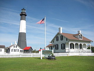
Chatham is a town in Barnstable County, Massachusetts, United States. Chatham is located at the southeastern tip of Cape Cod and has historically been a fishing community. First settled by the English in 1664, the township was originally called Monomoit based on the indigenous population's term for the region. Chatham was incorporated as a town on June 11, 1712, and has become a summer resort area. The population was 6,594 at the 2020 census and can swell to 25,000 during the summer months. There are four villages that comprise the town, those being Chatham (CDP), South Chatham, North Chatham, and West Chatham. Chatham is home to the Monomoy National Wildlife Refuge and the decommissioned Monomoy Point Light, both located on Monomoy Island. A popular attraction is the Chatham Light, which is an operational lighthouse that is operated by the United States Coast Guard.

The East Coast Greenway is a 3,000-mile (4,800 km) pedestrian and bicycle route between Maine and Florida along the East Coast of the United States. The nonprofit East Coast Greenway Alliance was created in 1991 with the goal to use the entire route with off-road, shared-use paths; as of 2021, over 1,000 mi (1,600 km) of the route (35%) meets these criteria. In 2020, the Greenway received over 50 million visits.

The Moriori are the first settlers of the Chatham Islands. Moriori are Polynesians who came from the New Zealand mainland around 1500 CE, which was close to the time of the shift from the archaic to the classic period of Polynesian Māori culture on the mainland. Oral tradition records migration to the Chathams in the 16th century. The settlers' culture diverged from mainland Māori, and they developed a distinct Moriori language, mythology, artistic expression and way of life. Currently there are around 700 people who identify as Moriori, most of whom no longer live on the Chatham Islands. During the late 19th century some prominent anthropologists proposed that Moriori were pre-Māori settlers of mainland New Zealand, and possibly Melanesian in origin; this hypothesis has been discredited by archaeologists since the early 20th century, but continued to be referred to by critics of the Treaty of Waitangi settlement process into the 21st.
Chatham Island is the largest island of the Chatham Islands group, in the south Pacific Ocean off the eastern coast of New Zealand's South Island. It is said to be "halfway between the equator and the pole, and right on the International Date Line", although that point is 173 miles WSW of the island's westernmost point. The island is called Rekohu in Moriori, and Wharekauri in Māori.

Waitangi is the main port and largest settlement of the Chatham Islands. It is situated on along the southern shore of Petre Bay, on the west coast of the archipelago's main island. With a population of 177 in the 2018 census, Waitangi is by far the largest settlement on the archipelago, accounting for about 27% of the group's population of 663.
Kaingaroa is the name of several places in New Zealand:

Torotoro National Park is a national park and town in Bolivia. The town was founded about 250 years ago by the Quechuas and the Spanish. It is located in the eastern mountain ranges of the South American Andes cordilleras in the area of Potosí.

Torotoro is a town in the Charcas Province, Potosí Department, Bolivia.

HMS Chatham was a Royal Navy survey brig, built in 1788, that accompanied HMS Discovery on George Vancouver's exploration of the West Coast of North America in his 1791–1795 expedition.

The yellow-billed kingfisher(Syma torotoro) is a medium-sized tree kingfisher.

Rangitahi Lake is located in the Chatham Islands of New Zealand. It is located on Chatham Island, to the northeast of Te Whanga Lagoon, close to the northern end of Hanson Bay.

HMS Torch was an Alert-class sloop of the Royal Navy, built at Sheerness Dockyard and launched in 1894. She served in Australia and New Zealand and was transferred to New Zealand as a training ship in 1917, being renamed HMS Firebrand at the same time. She was sold in 1920 and converted to a refrigerated ship with the new name Rama. She ran aground in the Chatham Islands in 1924 and was abandoned.
Kaingaroa, also called Kaingaroa Forest or Kaingaroa Village, is a small town southeast of Rotorua within the Bay of Plenty region of New Zealand's North Island. The town is the headquarters of Kaingaroa Forest.

The Moriori genocide was the mass murder, enslavement, and cannibalism of the Moriori people, the indigenous ethnic group of the Chatham Islands, by members of the mainland Māori New Zealand iwi Ngāti Mutunga and Ngāti Tama from 1835 to 1863. The invaders murdered around 300 Moriori and enslaved the remaining population. This, together with introduced Western diseases, caused the population to drop from 1,700 in 1835 to 100 in 1870. The last full-blood Moriori, Tommy Solomon, died in 1933. There remain just under a thousand people of mixed descent who identify as Moriori.
Lake Te Wapu is a shallow coastal dune lake in northeastern Chatham Island, New Zealand, adjacent to the Pacific coast and the village of Kaingaroa. Scrub and ranching land surround much of the lake. Leachate from a nearby rubbish dump has significantly raised the lake's nitrogen levels, leading to harmful algal blooms and poor water quality classified as supertrophic. The lake's proximity to the ocean allows significant amounts of seawater to intermittently flow into the lake, leading to brackish conditions. Large populations of inanga reside in the lake, alongside eels and New Zealand smelt. Several species of emergent plants grow along its shores.
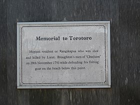 Plaque at the Torotoro Memorial
 Torotoro Memorial
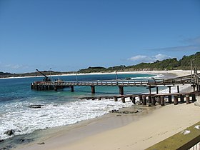 Kaingaroa Beach - below the Torotoro Memorial

