
Ticino, sometimes Tessin, officially the Republic and Canton of Ticino or less formally the Canton of Ticino, is one of the 26 cantons forming the Swiss Confederation. It is composed of eight districts and its capital city is Bellinzona. It is also traditionally divided into the Sopraceneri and the Sottoceneri, respectively north and south of Monte Ceneri. Red and blue are the colours of its flag.

Nidwalden or Nidwald is one of the 26 cantons forming the Swiss Confederation. It is composed of eleven municipalities and the seat of the government and parliament is in Stans. It is traditionally considered a "half-canton", the other half being Obwalden.

There are 106 municipalities in the canton of Ticino, Switzerland,. Municipalities (comuni) are grouped in circles (circoli) which are part of districts (distretti).

Districts of Switzerland are a political subdivision for cantons. In the federally constituted Switzerland, each canton is completely free to decide its own internal organisation. Therefore, there exists a variety of structures and terminology for the subnational entities between canton and municipality, loosely termed districts. Most cantons are divided into Bezirke. They are also termed Ämter, Amtsbezirke, district or distretto. The Bezirke generally provide only administration and court organization. However, for historical reasons districts in cantons Graubünden and Schwyz are their own legal entities with jurisdiction over tax and often have their own Landsgemeinde.

Lukmanier Pass is a pass in the Swiss Alps.
Torre means tower in seven Romance languages and may refer to:
Aquila is a former municipality in the district of Blenio in the canton of Ticino in Switzerland.
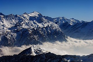
The Rheinwaldhorn is the highest point in the Swiss canton of Ticino at 3,402 metres above sea level. It lies on the border between the cantons of Graubünden and Ticino, in the Adula massif, part of the St. Gotthard massif of the Adula Alps in southern Switzerland.

Campo Blenio was a municipality in the district of Blenio in the canton of Ticino in Switzerland.
Ghirone was a municipality in the district of Blenio in the canton of Ticino in Switzerland.

Olivone was a municipality in the district of Blenio in the canton of Ticino in Switzerland.

Lai da Sontga Maria is a lake, located north of the Lukmanier Pass in Switzerland. It lies almost entirely in the municipality of Medel, a tiny fraction of the south-west part of the lake belonging to the municipalities of Quinto and Blenio. The reservoir has a surface area is 1.77 km2 (0.68 sq mi). The arch dam Santa Maria, which is to the north of the lake, was completed in 1968. The main road of the Lukmanier Pass runs along the eastern shore of the lake.
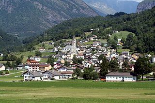
Blenio is a municipality of the district of Blenio, in the canton of Ticino, Switzerland.

Piz Terri is a mountain in the Lepontine Alps, located on the border between the cantons of Ticino and Graubünden. At 3,149 metres above sea level it is the highest summit lying on the chain between Greina and Soreda Pass. Piz Terri overlooks Lake Luzzone in Val Blenio on its west side, Val Sumvitg on its north side and Lumnezia on its east side. Close localities are Olivone and Vrin (Lumnezia).
Subdivisions of the canton of Ticino, Switzerland, are the 108 comuni grouped into 38 circoli, which in turn form a part or the whole of one of the eight districts.

The Rein da Medel is the longest headwater of the Rhine. It is located in the Swiss cantons of Ticino and Graubünden and flows through the valleys Val Cadlimo and Val Medel. Rein da Medel is the local Sursilvan, name in Graubünden, which is commonly used to denote the ticinese part as well.
Grumo may refer to several places:

Biasca railway station is a railway station in the Swiss canton of Ticino and municipality of Biasca. The station is on the original line of the Swiss Federal Railways Gotthard railway, at the foot of the southern ramp up to the Gotthard Tunnel.The line through the Gotthard Base Tunnel, now used by most trains on the Gotthard route, diverges from the existing line to the south of Biasca station, passing on the surface to the west of the town before entering the tunnel proper at Bodio. Biasca station can therefore only be served by trains on the slower, but much more scenic, original route.
The Moesa Region is one of the eleven administrative districts in the Canton of the Grisons in Switzerland. It had an area of 473.74 square kilometers (182.91 sq mi) and a population of 8,770 .. It was created on 1 January 2017 as part of a reorganization of the Canton.

The Fabbrica di Cioccolato Cima Norma S.A., also Chocolat Cima-Norma S.A., in Torre-Dangio was an industrial chocolate production company in the canton of Ticino. It was founded in 1903 by the Cima brothers. It went bankrupt in 1968. The company Cima Norma S.A. also stands for the economic development and modernization advancement goal from the beginning of the 20th century for the mountain valley Blenio Valley, which was classified as a peripheral region.


