
Socorro County is a county in the U.S. state of New Mexico. As of the 2010 census, the population was 17,866. The county seat is Socorro. The county was formed in 1852 as one of the original nine counties of New Mexico Territory. Socorro was originally the name given to a Native American village by Don Juan de Oñate in 1598. Having received vitally needed food and assistance from the native population, Oñate named the pueblo Socorro.
Conejos County is a county located in the U.S. state of Colorado. As of the 2020 census, the population was 7,461. The county seat is the unincorporated community of Conejos.

The Territory of New Mexico was an organized incorporated territory of the United States from September 9, 1850, until January 6, 1912. It was created from the U.S. provisional government of New Mexico, as a result of Nuevo México becoming part of the American frontier after the Treaty of Guadalupe Hidalgo. It existed with varying boundaries until the territory was admitted to the Union as the U.S. state of New Mexico. This jurisdiction was an organized, incorporated territory of the US for nearly 62 years, the longest period of any territory in the contiguous United States.

The Tularosa Basin is a graben basin in the Basin and Range Province and within the Chihuahuan Desert, east of the Rio Grande in southern New Mexico and West Texas, in the Southwestern United States.

The Robledo Mountains are a mountain range in Doña Ana County, New Mexico just northwest of Las Cruces. They are an uplifted block of Paleozoic rocks on the west side of the Rio Grande Rift.
The Doña Ana Mountains are a mountain range in Doña Ana County, New Mexico. The highest elevation in the range is Doña Ana Peak at 5835 feet / 1779 meters, at 32°27′15″N106°47′18″W.
Cathey Peak is a peak in the Sacramento Mountains, in the south-central part of the U.S. State of New Mexico. It lies in Otero County, 10 miles (16 km) southeast of the community of Alamogordo.

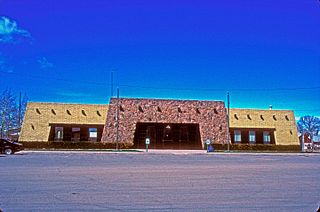
The New Mexico Farm and Ranch Heritage Museum is a 47-acre (190,000 m2) interactive museum in Las Cruces, New Mexico, that chronicles the state’s 3,000-year history of farming and ranching. The museum is part of the New Mexico Department of Cultural Affairs.

Doña Ana County is located in the southern part of the State of New Mexico, United States. As of the 2020 U.S. Census, its population was 219,561, which makes it the second-most populated county in New Mexico. Its county seat is Las Cruces, the second-most populous municipality in New Mexico after Albuquerque, with 111,385 as of the 2020 U.S. Census.
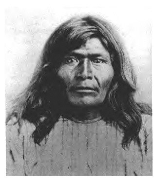
Victorio's War, or the Victorio Campaign, was an armed conflict between the Apache followers of Chief Victorio, the United States, and Mexico beginning in September 1879. Faced with arrest and forcible relocation from his homeland in New Mexico to San Carlos Indian Reservation in southeastern Arizona, Victorio led a guerrilla war across southern New Mexico, west Texas and northern Mexico. Victorio fought many battles and skirmishes with the United States Army and raided several settlements until the Mexican Army killed him and most of his warriors in October 1880 in the Battle of Tres Castillos. After Victorio's death, his lieutenant Nana led a raid in 1881.
Blue Mesa Observatory (BMO), also referred to Magdalena Peak Station for the International Planetary Patrol Program, was an astronomical observatory owned and operated by New Mexico State University (NMSU). It was located on Magdalena Peak in the Sierra de las Uvas of southern New Mexico (US), approximately 43 kilometers (27 mi) northwest of Las Cruces. Founded in 1967 under the supervision of Clyde Tombaugh, the observatory was closed in 1993. The site and the 30 acres surrounding it were conveyed to the Federal Aviation Administration, which tore down the observatory building and replaced it with a radar installation.
Tortugas Mountain Observatory (TMO) is an astronomical observatory owned and operated by New Mexico State University (NMSU). It is located on Tortugas Mountain, also known locally as 'A' Mountain, in southern New Mexico (USA), approximately 8 kilometers (5.0 mi) southeast of Las Cruces and 4 kilometers (2.5 mi) east of the NMSU campus. Founded in 1963 under the supervision of Clyde Tombaugh, the observatory focused on observing the planets. Much of the information captured at TMO is now available through the Planetary Data System's Atmospheres Node, which is managed by NMSU. The two-dome observatory building was completed in 1964, though observing began with one of the telescopes in 1963. A second building, with a larger single dome, was completed at the opposite end of the ridgeline of Tortugas Mountain in 1967. Regular use of TMO ceased in 1999 or 2000, but the observatory equipment was not dismantled. In 2008 it was used for the Lunar CRater Observing and Sensing Satellite project. In 2010, efforts to revive the observatory for use by the American Association of Variable Star Observers began. As of 10 June 2011, work on project was reported to be 60-75% done.

The New Mexico State University Golf Course is an 18–hole golf course within the campus of New Mexico State University, in the city of Las Cruces, New Mexico. The golf course was established in 1963 and is opened to the public. It features 4 sets of tees for different skill levels and measures 7078 yards from the longest tees. The golf course has a slope rating of 129 and a 72.7 USGA rating. It is also the home of New Mexico State Aggies' men's and women's golf team.
Picacho, is a populated place in Doña Ana County, New Mexico. It lies at an elevation of 3,907 feet / 1,191 meters.
Picacho Mountain, also known as El Picacho and Picacho Peak, is a summit in Doña Ana County, New Mexico. It rises to an elevation of 4,954 feet / 1,510 meters.

The Our Lady of Guadalupe Cathedral Also Ciudad Juárez Cathedral Is the name of a Catholic cathedral church dedicated to the Virgin of Guadalupe, that is located in Ciudad Juárez in the border state of Chihuahua, in Mexico, in the area called Historical Center. It was built in the middle of the second half of the twentieth century and is attached to the old and still preserved Franciscan mission, founded in the 17th century, in the then Paso del Norte.
The Fiesta of Our Lady of Guadalupe in the village of Tortugas, New Mexico, in Doña Ana County, New Mexico, is an annual three day festival in December. It includes processions, church services, traditional dances, and a 4-mile (6.4 km) pilgrimage up Tortugas Mountain. The festival is held December 10, 11, 12.
Tortugas, New Mexico or Tortugas Pueblo is a community in Doña Ana County, New Mexico, just outside of Las Cruces, New Mexico.
