
Martin Waldseemüller was a German cartographer and humanist scholar. Sometimes known by the Latinized form of his name, Hylacomylus, his work was influential among contemporary cartographers. He and his collaborator, Matthias Ringmann, are credited with the first recorded usage of the word America to name a portion of the New World in honour of the Italian explorer Amerigo Vespucci. Waldseemüller was also the first to map South America as a continent separate from Asia; the first to produce a printed globe and the first to create a printed wall map of Europe. A set of his maps printed as an appendix to the 1513 edition of Ptolemy's Geography is considered to be the first example of a modern atlas.

Claudius Ptolemy was a mathematician, astronomer, natural philosopher, geographer and astrologer who wrote several scientific treatises, three of which were of importance to later Byzantine, Islamic and Western European science. The first is the astronomical treatise now known as the Almagest, although it was originally entitled the Mathematical Treatise and then known as The Great Treatise. The second is the Geography, which is a thorough discussion of the geographic knowledge of the Greco-Roman world. The third is the astrological treatise in which he attempted to adapt horoscopic astrology to the Aristotelian natural philosophy of his day. This is sometimes known as the Apotelesmatiká (Ἀποτελεσματικά) but more commonly known as the Tetrábiblos from the Koine Greek (Τετράβιβλος) meaning "Four Books" or by the Latin Quadripartitum.
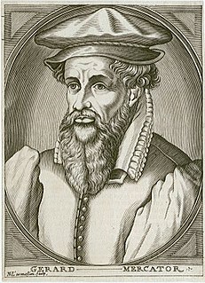
Gerardus Mercator was a 16th-century geographer, cosmographer and cartographer from the County of Flanders. He is most renowned for creating the 1569 world map based on a new projection which represented sailing courses of constant bearing as straight lines—an innovation that is still employed in nautical charts.

Abraham Ortelius was a Brabantian cartographer, geographer, and cosmographer, conventionally recognized as the creator of the first modern atlas, the Theatrum Orbis Terrarum. Ortelius is often considered one of the founders of the Netherlandish school of cartography and one of the most notable figures of the school in its golden age. The publication of his atlas in 1570 is often considered as the official beginning of the Golden Age of Netherlandish cartography. He is also believed to be the first person to imagine that the continents were joined before drifting to their present positions.
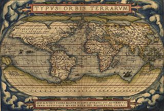
Theatrum Orbis Terrarum is considered to be the first true modern atlas. Written by Abraham Ortelius, strongly encouraged by Gillis Hooftman and originally printed on 20 May 1570 in Antwerp, it consisted of a collection of uniform map sheets and supporting text bound to form a book for which copper printing plates were specifically engraved. The Ortelius atlas is sometimes referred to as the summary of sixteenth-century cartography. The publication of the Theatrum Orbis Terrarum (1570) is often considered as the official beginning of the Golden Age of Netherlandish cartography.

Carta marina et descriptio septentrionalium terrarum is the first map of the Nordic countries to give details and place names, created by Swedish ecclesiastic Olaus Magnus and initially published in 1539. Only two earlier maps of the Nordic countries are known, those of Jacob Ziegler and Claudius Clavus.

Johannes Honter was a Transylvanian Saxon, renaissance humanist, Protestant reformer, and theologian. Honter is best known for his geographic and cartographic publishing activity, as well as for implementing the Lutheran reform in Transylvania and founding the Evangelical Church of Augustan Confession in Romania.

TheodoreBibliander was a Swiss orientalist, publisher, Protestant reformer and linguist. Born Theodor Buchmann in Bischofszell, he studied Latin under Oswald Myconius, and Greek and Hebrew under Jakob Ceporin, and attended lectures in Basel between 1525–7 given by Johannes Oecolampadius and Konrad Pelikan. He also became familiar with the Arabic language and other languages from the East; he became a professor of theology. He published a Hebrew grammar in 1535, and commentaries on the Bible. He published the first printed edition of the Qur'an in Latin, based on the medieval translation of Robert of Ketton. The edition included Doctrina Machumet, a translation of the Arabic theological tract known as the Book of a Thousand Questions. Considered the father of biblical exegesis in Switzerland, Bibliander became involved in a doctrinal controversy with Pietro Martire Vermigli over predestination; he was removed from his theological professorship at the Carolinum academy in 1560. He died of the plague.
The earliest known world maps date to classical antiquity, the oldest examples of the 6th to 5th centuries BCE still based on the flat Earth paradigm. World maps assuming a spherical Earth first appear in the Hellenistic period. The developments of Greek geography during this time, notably by Eratosthenes and Posidonius culminated in the Roman era, with Ptolemy's world map, which would remain authoritative throughout the Middle Ages.

The Geography, also known by its Latin names as the Geographia and the Cosmographia, is a gazetteer, an atlas, and a treatise on cartography, compiling the geographical knowledge of the 2nd-century Roman Empire. Originally written by Claudius Ptolemy in Greek at Alexandria around AD 150, the work was a revision of a now-lost atlas by Marinus of Tyre using additional Roman and Persian gazetteers and new principles. Its translation into Arabic in the 9th century and Latin in 1406 was highly influential on the geographical knowledge and cartographic traditions of the medieval Caliphate and Renaissance Europe.
The Cartography of Switzerland is the history of surveying and creation of maps of Switzerland. Switzerland has had its current boundaries since 1815, but maps of the Old Swiss Confederacy were drawn since the 16th century. The first topographical survey on a federal level began in 1809, resulting in the Topographic Map of Switzerland or Dufour Map. From 1869 to 1901, this map was replaced by the Topographic Atlas of Switzerland or Siegfried Map.

Giacomo Gastaldi was an Italian cartographer, astronomer and engineer of the 16th century. Gastaldi began his career as an engineer, serving the Venetian Republic in that capacity until the fourth decade of the sixteenth century. From about 1544 he turned his attention entirely to mapmaking, and his work represents several important turning points in cartographic development.
Nikolaos Sophianos was a Greek Renaissance humanist and cartographer chiefly noted for his Totius Graeciae Descriptio map and his grammar of Greek. He was born into the local nobility of Corfu at the beginning of the 16th century and was educated at the Greek Quirinal College in Rome, co-founded by another Greek scholar, Janus Lascaris, who also became his teacher along with Arsenius Apostolius. Sophianos did not return to live in Greece; only briefly visiting in 1543. He spent the rest of his life in Rome where he became a librarian, and Venice where he worked as a copyist. His cartographical work was published in 1540.

Hadrianus Junius (1511–1575), also known as Adriaen de Jonghe, was a Dutch physician, classical scholar, translator, lexicographer, antiquarian, historiographer, emblematist, school rector, and Latin poet.

Nikolaus Gerbel was a German humanist, jurist and doctor of both laws.
In Greek mythology, Sicyon is the eponym of the polis of the same name, which was said to have previously been known as Aegiale and, earlier, Mecone. His father is named variously as Marathon, Metion, Erechtheus or Pelops. Sicyon married Zeuxippe, the daughter of Lamedon, the previous king of the polis and region that would come to be named after him. They had a daughter Chthonophyle, who bore two sons: Polybus to Hermes and, later, Androdamas to Phlius, the son of Dionysus. However, in some accounts, Chthnophyle bore Phlius to Dionysus instead.

Pieter van den Keere was a Flemish engraver, publisher and globe maker who worked for the most part of his career in England and the Dutch Republic.

Pietro Coppo was an Italian geographer and cartographer who wrote a description of the entire world as known in the 16th century, accompanied by a set of systematically arranged maps, one of the first rutters and also a precise description of the Istrian Peninsula, accompanied by its first regional map.
Expositio totius mundi et gentium refers to a brief "commercial-geographical" survey written by an anonymous citizen of the Roman Empire living during the reign of Constantius II. The Greek original, composed between AD 350 and 362, is now lost, but comes to us through two Latin translations made during the sixth century.
