Tottington Hall

Last updated

Tottington Hall
Tottington Hall (geograph 6542989).jpg
The building in 2020
LocationMarket Street, Tottington
Coordinates 53°36′46″N2°20′25″W / 53.6128°N 2.3404°W / 53.6128; -2.3404
Builtc.1820
Architectural style(s) Neoclassical style
Listed Building – Grade II
Official nameTottington Hall
Designated5 October 1982
Reference no.1163648
Greater Manchester UK location map 2.svg
Red pog.svg
Shown in Greater Manchester

Tottington Hall, also known as Tottington Town Hall, is a municipal building in Market Street, Tottington, a town in Greater Manchester in England. The building, which served as the offices and meeting place of Tottington Urban District Council and now operates as a public library, is a grade II listed building. [1]

Contents

History

The original building on the site was a private house, commissioned for a branch of the Notogh family, later known as the Nuttall family, [2] which dated back to around 1504. [3] After Thomas Nuttall died without descendants in 1727, [4] his executors did much to expand and consolidate the estate. The house was subsequently occupied by the Wood family who were proprietors of a local tannery. [5] In 1770, the house was acquired by John Gorton who, through the development of local mills and bleachworks, made a major contribution to the development of the town in the early 19th century. [6]

The house then passed to Thomas Gorton, who had it refurbished and re-modelled, in around 1820. A whole new wing was erected on the front of the house facing east towards a newly laid lawn. The new wing was designed in the neoclassical style and was built in ashlar stone. The house was bought by two schoolmasters, James Hainsworth and George Hudson in 1863, and then by the Roberts family in the late 19th century. [3]

In 1918, the house was purchased by Tottington Urban District Council for £2,750, for use as its town hall. [7] [8] A war memorial, designed by Walter Marsden in the form of a Portland stone wall with a simple cross in the centre, which was intended to commemorate the lives of local service personnel who had died in the First World War, was unveiled to the south of the town hall in April 1930. [9] [10]

The town hall continued to serve as the headquarters of the borough council for much of the 20th century, [11] but ceased to be the local seat of government when for the enlarged Bury Borough Council which was formed in 1974. [12] The council subsequently opened a library on the ground floor of the building, while the upper floor was disused. [13] The council announced the closure of the library in 2017, but it was taken over by a voluntary group, which added a tea room, and made two conference rooms upstairs available for hire. [14]

In July 2022, the Town Park Meadow, to the east of the town hall, was renamed Private Peachment VC Town Meadow Park in memory of Private George Peachment of the King's Royal Rifle Corps, who was posthumously awarded the Victoria Cross for his bravery at the Battle of Loos on 25 September 1915. A mural illustrating his life was unveiled at the same time. [15] [16] [17]

Architecture

The two-storey building has been grade II listed since 1982. It is five bays wide, with sash windows and a central door with half columns and a cornice hood. It is built of stone, and has a slate roof. [1] Behind the front wing are the older parts of the complex which include the stables. [18]

See also

Related Research Articles

<span class="mw-page-title-main">Denton, Greater Manchester</span> Town in Greater Manchester, England

Denton is a town in Tameside, Greater Manchester, England, five miles (8 km) east of Manchester city centre. Historically part of Lancashire, it had a population of 36,591 at the 2011 Census.

<span class="mw-page-title-main">Bury, Greater Manchester</span> Market town in Greater Manchester, England

Bury is a market town on the River Irwell in the Metropolitan Borough of Bury, Greater Manchester, England. which had a population of 81,101 in 2021 while the wider borough had a population of 193,846.

<span class="mw-page-title-main">Eston</span> Area of Redcar and Cleveland, North Yorkshire, England

Eston is an area of Redcar and Cleveland in North Yorkshire, England. The local authority ward covering the area had a population of 7,005 at the 2011 census. It is part of Greater Eston, which includes the outlying settlements of Grangetown, Normanby, South Bank, Teesville and part of Ormesby.

<span class="mw-page-title-main">Rochdale</span> Town in Greater Manchester, England

Rochdale is a town in Greater Manchester, England, and the administrative centre of the Metropolitan Borough of Rochdale. In the 2021 census the town had a population of 111,261, compared to 223,773 for the wider borough. Rochdale is in the foothills of the South Pennines and lies in the dale (valley) of the River Roch, 5 miles (8 km) northwest of Oldham, and 10 miles (16 km) northeast of Manchester.

<span class="mw-page-title-main">Metropolitan Borough of Bury</span> Borough of Greater Manchester, England

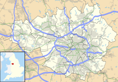
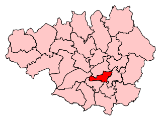
The Metropolitan Borough of Bury is a metropolitan borough of Greater Manchester in England. It is north of Manchester, to the east of Bolton and west of Rochdale. The borough is centred around the town of Bury but also includes other towns such as Ramsbottom, Tottington, Radcliffe, Whitefield and Prestwich. Bury bounds the Lancashire districts of Rossendale and Blackburn with Darwen to the north. With a population of 193,823 in 2021, it is the smallest borough in Greater Manchester.

<span class="mw-page-title-main">Middleton, Greater Manchester</span> Town in Greater Manchester, England

Middleton is a town in the Metropolitan Borough of Rochdale, Greater Manchester, England, on the River Irk 5 miles (8.0 km) southwest of Rochdale and 5 miles (8.0 km) northeast of Manchester. Middleton had a population of 42,972 at the 2011 Census. It lies on the northern edge of Manchester, with Blackley to the south and Moston to the south east.

<span class="mw-page-title-main">James Pitts (VC)</span> Recipient of the Victoria Cross

James Pitts VC MSM was an English recipient of the Victoria Cross, the highest and most prestigious award for gallantry in the face of the enemy that can be awarded to British and Commonwealth forces.

<span class="mw-page-title-main">Ramsbottom</span> Town in Greater Manchester, England

Ramsbottom is a market town in the Metropolitan Borough of Bury, Greater Manchester, England. The population at the 2011 census was 17,872.

<span class="mw-page-title-main">Peel Monument, Ramsbottom</span> Commemorative monument

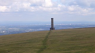
The Peel Monument at Ramsbottom, Lancashire, England, is one of two monuments in the area erected in memory of Prime Minister and founder of the police force Robert Peel, who was born in Bury. It is on Harcles Hill near Ramsbottom, 1100 feet above sea level. Because of its proximity to the village of Holcombe, Harcles Hill is more commonly known as Holcombe Hill and the monument as Holcombe or Peel Tower.

<span class="mw-page-title-main">Tottington, Greater Manchester</span> Human settlement in England

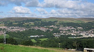
Tottington is a town in the Metropolitan Borough of Bury in Greater Manchester, England, on the edge of the West Pennine Moors.

<span class="mw-page-title-main">Bury North (UK Parliament constituency)</span> Parliamentary constituency in the United Kingdom, 1983 onwards

Bury North is a borough constituency in Greater Manchester, created in 1983 and represented in the House of Commons of the UK Parliament. With a Conservative majority of 105 votes, it is the most marginal constituency for a sitting MP in the United Kingdom as of the 2019 general election.

<span class="mw-page-title-main">Manchester Gorton (UK Parliament constituency)</span> Parliamentary constituency in the United Kingdom, 1885 onwards

Manchester Gorton is a constituency represented in the House of Commons of the UK Parliament by Labour's Afzal Khan, who was elected at the 2017 general election. It is the safest Labour seat in Greater Manchester by numerical majority and one of the safest in the country.

<span class="mw-page-title-main">Holcombe, Greater Manchester</span> Human settlement in England

Holcombe is a village in Ramsbottom ward, Metropolitan Borough of Bury, in Greater Manchester, England. It is situated south of Haslingden, east of Edgworth, west of Ramsbottom, and north of Tottington. The name comes from the Celtic cwm meaning valley, and the Old English hol, meaning deep or hollow.

<span class="mw-page-title-main">Affetside</span> Village in the Metropolitan Borough of Bury, in Greater Manchester, England

Affetside is a village in Greater Manchester, England. Historically in Lancashire, it is in the Tottington ward of Bury Metropolitan Borough Council and the Bury North parliamentary constituency, in the West Pennine Moors.

<span class="mw-page-title-main">Christ Church, Walshaw</span> Church in Greater Manchester, England

Christ Church is an active church in Walshaw, Greater Manchester, England, and is a Grade II* listed building. Designed in the Gothic Revival style by Lawrence Booth in 1888, the building was funded by Rev John Gorrell Haworth and Miss Nancy Haworth, and took four years to complete. It was erected as a memorial to Manchester cotton and fustian manufacturer Jesse Haworth, as noted prominently across the west facade of the building.

<span class="mw-page-title-main">County Borough of Bury</span>

Bury was a local government district centred on Bury in the northwest of England from 1846 to 1974.

<span class="mw-page-title-main">Fusilier Museum</span> War museum in Moss Street, Bury

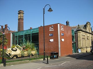
The Fusilier Museum is a museum in Bury, Greater Manchester, England. Its collection includes the uniforms, medal and artefacts of the Lancashire Fusiliers.

Tottington is a town in the Metropolitan Borough of Bury, Greater Manchester, England, and the area also includes the villages of Walshaw and Greenmount and the surrounding countryside. The area is unparished, and contains 33 listed buildings that are recorded in the National Heritage List for England. Of these, two are listed at Grade II*, the middle grade, and the others are at Grade II, the lowest grade. The area is partly agricultural and partly residential, and its listed buildings include farmhouses and farm buildings, private houses and associated structures, an ancient cross, churches and associated structures, a village lock-up, and schools.

<span class="mw-page-title-main">Bury Town Hall</span> Municipal building in Bury, Greater Manchester, England

Bury Town Hall is a municipal building in Knowsley Street, Bury, Greater Manchester, England. The town hall, which is the headquarters of Metropolitan Borough of Bury, is a locally listed building.

<span class="mw-page-title-main">Radcliffe Town Hall</span> Municipal building in Radcliffe, Greater Manchester, England

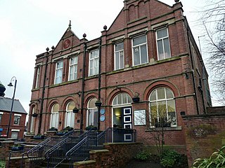
Radcliffe Town Hall is a municipal structure in Spring Lane in Radcliffe, Greater Manchester, England. The town hall, which was the headquarters of Radcliffe Borough Council, is a locally listed building.

References

  1. 1 2 Historic England. "Tottington Hall (1163648)". National Heritage List for England . Retrieved 3 March 2024.
  2. Baines, Edward (1836). The History of the County Palatine and Duchy of Lancaster (PDF). Vol. 3. John Heywood. p. 15.
  3. 1 2 "Town Meadow Park, Tottington Green Flag 5 year management plan 2009–2013". Bury Borough Council. 1 January 2005. p. 18. Archived from the original on 23 September 2015. Retrieved 3 March 2024.
  4. A History of the County of Lancaster: Volume 5. London: Victoria County History. 1911. Retrieved 2 March 2024.
  5. Brandes, Inga (2006). Being poor in modern Europe historical perspectives 1800–1940. Peter Lang. p. 73. ISBN   978-3039102563.
  6. "Walk 9 Greenmount to Walshaw". Village Link. Retrieved 3 March 2024.
  7. "Private Peachment VC Town Meadow Park". Bury Council. Retrieved 2 March 2024.
  8. Anson, John (17 April 2022). "Tottington certainly had impressive-looking council offices". Bury Times. Retrieved 2 March 2024.
  9. "Tottington". Imperial War Museum. Retrieved 3 March 2024.
  10. "Tottington War Memorial". War Memorials Online. Retrieved 3 March 2024.
  11. "No. 46130". The London Gazette . 16 November 1973. p. 13654.
  12. Local Government Act 1972. 1972 c.70. The Stationery Office Ltd. 1997. ISBN   0-10-547072-4.
  13. "Tottington - That makes 32 years". Lancashire Life. March 1980. Retrieved 2 March 2024.
  14. George, Thomas (15 March 2018). "Tottington Centre and Community Centre reopens after being saved from closure by volunteers". Bury Times. Retrieved 2 March 2024.
  15. "Mural in Tottington pays tribute to Victoria Cross recipient". Bury Times. 19 July 2022. Retrieved 3 March 2024.
  16. "Memorial takes place to remember Tottington war hero". Bury Times. 27 September 2022. Retrieved 3 March 2024.
  17. "Bury's only Victoria Cross war hero who died saving his commanding officer honoured 100 years on". ITV News. 28 September 2022. Retrieved 3 March 2024.
  18. Hartwell, Clare; Hyde, Matthew; Pevsner, Nikolaus (2004). Lancashire Manchester and the South-East (Buildings of England Series). Yale University Press. p. 664. ISBN   978-0300105834.