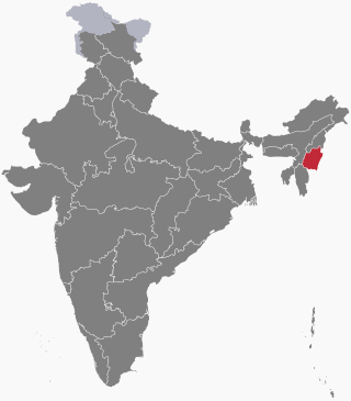
Manipur is a state in northeast India, with the city of Imphal as its capital. It is bounded by the Indian states of Nagaland to the north, Mizoram to the south and Assam to the west. It also borders two regions of Myanmar, Sagaing Region to the east and Chin State to the south. The state covers an area of 22,327 km2 (8,621 sq mi). The official and most widely spoken language is the Meitei language. Native to the Meitei people, it is also used as a lingua franca by smaller communities, who speak a variety of other Tibeto-Burman languages. Manipur has been at the crossroads of Asian economic and cultural exchange for more than 2,500 years. This exchange connects the Indian subcontinent and Central Asia to Southeast Asia, East Asia, Siberia, regions in the Arctic, Micronesia and Polynesia enabling migration of people, cultures and religions.

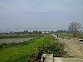
The Loktak Lake is a freshwater lake in Northeast India. It is the largest freshwater lake in South Asia. It is a pulsating lake, with a surface area varying from 250 sq km to 500 sq km during the rainy season with a typical area of 287 sq km. The lake is located at Moirang in Manipur state, India. The etymology of Loktak is Lok = "stream" and tak = "the end" in Meitei language. It is famous for the phumdi floating over it. The largest of all the phumdis covers an area of 40 km2 (15 sq mi) and is situated on the southeastern shore of the lake. Located on this phumdi, Keibul Lamjao National Park is the only floating national park in the world. The park is the last natural refuge of the endangered Sangai, Rucervus eldii eldii or Manipur brow-antlered deer, one of three subspecies of Eld's deer.

The Keibul Lamjao National Park is a national park in the Bishnupur district of the state of Manipur in Northeast India. It is 40 km2 (15.4 sq mi) in area, the only floating national park in the world, and an integral part of Loktak Lake. It is currently under the tentative lists of the UNESCO World Heritage Sites, under the title "Keibul Lamjao Conservation Area (KLCA)", additionally covering the buffer of Loktak Lake and Pumlen Pat.

Moirang is a town in the Indian state of Manipur, best known for the tentatively listed UNESCO World Heritage Sites of the Keibul Lamjao Conservation Area (KLCA), covering Keibul Lamjao National Park (KLNP), the world's only floating national park, the buffer of Loktak Lake and Pumlen Pat. It is best known for the being the place of origin of the ancient epic legend of Khamba and Thoibi, one of the seven epic cycles of incarnations of Meitei mythology and folklore. Nationwide, it is also famous for the INA War Museum in the INA Martyrs' Memorial Complex, where Colonel Shaukat Malik of the Indian National Army hoisted the Tricolour for the first time on Indian soil on 14 April 1944. It is situated approximately 45 km (28 mi) south of the state capital Imphal. It has an area of 269 km2 (104 sq mi) with a population of 62,187 in 67 villages. There are 12 Panchayats in this block.
Kakching is a town in the southeastern part of the Indian state of Manipur. It serves as the headquarters of Kakching district and is a major commercial hub in the state. In 2018, Kakching was declared as the cleanest city in North East India by the Swachh Bharat Mission of the Indian government.

Thoubal district is one of the sixteen districts of Manipur state in northeastern India. This district is bounded by Senapati district on the north, Ukhrul and Chandel districts on the east, Churchandpur and Bishnupur districts on the south and Imphal West and Imphal East districts on the west. The district occupies an area of 324 km2. The population as of 2011 is 286,687. Thoubal town is the district headquarters. This district is known for Khongjom, where the last battle of the independence of Manipur was fought in April 1891 against the British army.

Bhaktisvarupa Damodara Swami, also known as Dr. Thoudam Damodara Singh and by the honorific Sripada, was a Gaudiya Vaishnava spiritual leader, chemist, writer about religion and science, and poet. In 1971 he received spiritual initiation from A. C. Bhaktivedanta Swami Prabhupada. A few years later he became one of the religious leaders of the International Society for Krishna Consciousness.
Mayang Imphal is a town and municipal council in Imphal West district in the Indian state of Manipur. Pin code of Mayang Imphal is 795132.
Nambol is a Town of Manipur, India. It Stretches across one of the major heartline of Highway Known as Tiddim Road.The General functionalities are under administration of Nambol municipal council Most part of Nambol comes under Bishnupur district, While some parts of Nambol belongs to Imphal west District. Nambol as a whole is known to be a Sub- Division. Nambol is one of the educational hubs of Bishnupur district as well as of Manipur. Its market, known as Nambol Bazaar is the second most busiest market, after Khwairamband Bazaar( also known as 'IMA market' ) in Manipur. It is Famous for the local snacks known as Nambol Bora.It is also the birth place of Lairenjam Dhanashyam.
Ningthoukhong is a town and a Municipal Council having 14 wards in Bishnupur district in the Indian state of Manipur.
Samurou is a town and a Municipal Council in Imphal West district in the Indian state of Manipur. The town is about 13 kilometres from Imphal via Mayai Lambi Road and is on the banks of Imphal River
Mukna is a form of folk wrestling from the north-east Indian state of Manipur. It is popular in Imphal, Thoubal and Bishnupur. The game is generally played on the last day of the Lai Haraoba festival and is an intrinsic part of the ceremonial functions.

Manipuri Vaishnavism, also known as Meitei Vaishnavism is a regional variant of Gaudiya Vaishnavism with a culture-forming role in the north-eastern Indian state of Manipur.
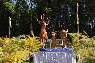
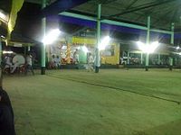
Sangai Festival is an annual cultural festival organised by Manipur Tourism Department every year from 21 to 30 November. Even though many editions of this Festival has been celebrated over the past few years with the name of Tourism Festival, since 2010 this has been renamed as the Sangai Festival to stage the uniqueness of the shy and gentle brow-antlered deer popularly known as the Sangai, a regional name given to this rare species of deer. It is the state animal of Manipur. As this festival is being celebrated to promote Manipur as a world class tourism destination, it showcases the states contributions to art and culture, handloom, handicrafts, fine arts, indigenous sports, cuisine, music and adventure sports, as well as the natural environment. it is celebrated in different parts mainly in the valley areas of imphal. Many tourists come from all over the world and represent their craft making. Many people have also started to talk about the way Sangai festival is celebrated. They say that it should be celebrated only in one place with a proper arrangement and with big budget so that this festival grows more bigger and unique and spread all over the world.
The following outline is provided as an overview of and topical guide to Manipur:
Wangoo is a village in the Kakching district of the Indian state of Manipur. It is situated approximately 64 km south of the state capital, Imphal. It has an area of 13.05 km2 with a population of 6134.
Khoijuman is a small village situated within the Bishnupur district in the Indian state of Manipur. It is located about 30 km (19 mi) to the south of Imphal. It has population of about 3000 (approx) with 1460 are males and 1490 are females.

The Loktak Folklore Museum or the Thanga Folklore Museum is a folk museum in Thanga Island in the Loktak lake of Manipur, India. It cares for and displays a collection of artistic, cultural and historical artefacts associated with the Loktak lake. The museum preserves the folk customs and beliefs, folk medicines, folk literature associated with the Loktak lake.