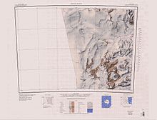
Towle Valley ( 76°41′S160°45′E / 76.683°S 160.750°E ) is the deep valley formerly occupied by the head of Towle Glacier, lying immediately west of Towle Glacier in the Convoy Range of Victoria Land, Antarctica. [1]
Contents

Towle Valley ( 76°41′S160°45′E / 76.683°S 160.750°E ) is the deep valley formerly occupied by the head of Towle Glacier, lying immediately west of Towle Glacier in the Convoy Range of Victoria Land, Antarctica. [1]
Towle Valley was mapped in 1957 by the New Zealand Northern Survey Party of the Commonwealth Trans-Antarctic Expedition (1956–58). It was named by them for the USNS Private John R. Towle, an American freighter which carried a large part of the New Zealand stores south in December 1956. [1]
The glacier runs east of northeast to Fry Glacier between Elkhorn Ridge to the south and Eastwind Ridge to the north. [2] The valley is at its former head. [1] Features include
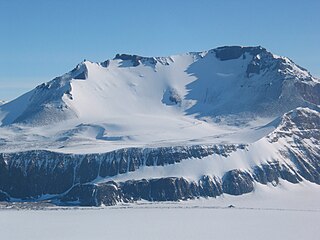
76°44′S160°40′E / 76.733°S 160.667°E . The irregular, mainly ice-free heights which rise to about 2,000 metres (6,600 ft) at the south side of the head of Towle Valley. The name was applied by a 1989-90 NZARP field party to describe the windy aspect of this upland area. [3]
76°41′S160°28′E / 76.683°S 160.467°E . The highest summit, 2,270 metres (7,450 ft) high, in the north part of the Convoy Range, standing at the north side of the head of Towle Valley. Named by the 1976-77 Victoria University's Antarctic Expeditions (VUWAE), led by Christopher J. Burgess, after New Zealand author Maurice Shadbolt. [4]

The Nimrod Glacier is a major glacier about 85 nautical miles long, flowing from the polar plateau in a northerly direction through the Transantarctic Mountains into the Ross Ice Shelf, Antarctica.
The Tapley Mountains is a range of mountains fronting on the eastern side of the Scott Glacier, extending eastward for 35 nautical miles between Leverett Glacier and Albanus Glacier in the Queen Maud Mountains of Antarctica.

The Priestley Glacier is a major valley glacier, about 60 nautical miles long, originating at the edge of the Polar Plateau of Victoria Land, Antarctica. The glacier drains southeast between the Deep Freeze Range and Eisenhower Range to enter the northern end of the Nansen Ice Sheet. It was first explored by the Northern Party of the British Antarctic Expedition, 1910–13, and named for Raymond Priestley, a geologist with the Northern Party.
The Prince Albert Mountains are a major mountain group in Antarctica over 200 nautical miles long. Located in Victoria Land, they run north–south between the Priestley Glacier to the north and Ferrar Glacier to the south. They are south of the Deep Freeze Range and north of the Kirkwood Range.

The Quartermain Mountains are a group of exposed mountains in Antarctica, about 20 nautical miles long, typical of ice-free features of the McMurdo Dry Valleys, Victoria Land. They are east of the Lashly Mountains, south of the Asgard Range, west of the Kukri Hills and Royal Society Range, and some distance north of the Worcester Range.
The Allan Hills are a group of hills, mainly ice free and about 12 nautical miles long, lying just north-west of the Coombs Hills near the heads of Mawson Glacier and Mackay Glacier in the Oates Land and Victoria Land regions of Antarctica.

Convoy Range is a broad range in Antarctica. It is south of the Kirkwood Range and north of the Clare Range.
The Worcester Range is a high coastal range, about 30 nautical miles long, in Antarctica. It stands between Skelton Glacier and Mulock Glacier on the western side of the Ross Ice Shelf. It is southwest of the Royal Society Range and north of the Conway Range of the Cook Mountains.
Rennick Glacier is broad glacier, nearly 200 nautical miles long, which is one of the largest in Antarctica. It rises on the polar plateau westward of Mesa Range and is 20 to 30 nautical miles wide, narrowing to 10 nautical miles near the coast. It takes its name from Rennick Bay where the glacier reaches the sea.
Benson Glacier is a glacier about 12 nautical miles long, draining the east part of Flight Deck Névé and continuing east between Fry Glacier and Mackay Glacier into the north part of Granite Harbour where it forms a floating tongue.
The Odell Glacier is a glacier draining northeast between Allan Hills and Coombs Hills into the upper Mawson Glacier in Victoria Land, Antarctica. It was named by the New Zealand Antarctic Place-Names Committee (NZ-APC) for Noel Odell, who was a mountaineer and was professor of geology at the University of Otago from 1950 to 1955.
Cotton Plateau is a snow-covered plateau just east of the mouth of Marsh Glacier, in the Queen Elizabeth Range.
Fry Glacier is a glacier draining the slopes at the northeast corner of the Convoy Range and flowing along the south end of the Kirkwood Range into Tripp Bay, Victoria Land, Antarctica. It was first charted by the British Antarctic Expedition, 1907–09, and named for A.M. Fry, a contributor to the expedition.
The Grosvenor Mountains are a group of widely scattered mountains and nunataks rising above the Antarctic polar plateau east of the head of Mill Glacier, extending from Mount Pratt in the north to the Mount Raymond area in the south, and from Otway Massif in the northwest to Larkman Nunatak in the southeast.
Greenville Valley is the large mainly ice-free valley lying south of Elkhorn Ridge in the Convoy Range of Victoria Land, Antarctica. A lobe of the Northwind Glacier flows a short distance west into the mouth of the valley. Near the head of the valley the south wall is breached by the entrance to Merrell Valley.
Eastwind Ridge is a broad, partially ice-covered ridge about 10 nautical miles long between Chattahoochee Glacier and Towle Glacier in the Convoy Range of Antarctica.
Molar Massif is a large mountain massif immediately east of the Lanterman Range in the Bowers Mountains of Antarctica. It was mapped by the United States Geological Survey (USGS) from ground surveys and United States Navy air photos, 1960–1964. The descriptive name was applied by the United States Advisory Committee on Antarctic Names (US-ACAN) because, when viewed in plan, the outline of the massif resembles a molar tooth.
The Mawson Glacier is a large glacier on the east coast of Victoria Land, Antarctica, descending eastward from the Antarctic Plateau to the north of Trinity Nunatak and the Kirkwood Range, to enter the Ross Sea, where it forms the Nordenskjöld Ice Tongue. The glacier was first mapped by the British Antarctic Expedition (1907–09) and named for Douglas Mawson, the expedition physicist, who later led two other Antarctic expeditions, 1911–14, and 1929–31.
Staten Island Heights is a predominantly flat, ice-covered upland between Greenville Valley and Alatna Valley in the Convoy Range of Victoria Land, Antarctica.
The La Gorce Mountains are a group of mountains, 20 nautical miles long, standing between the tributary Robison Glacier and Klein Glacier at the east side of the upper reaches of the Scott Glacier, in the Queen Maud Mountains of Antarctica.
![]() This article incorporates public domain material from websites or documents of the United States Geological Survey .
This article incorporates public domain material from websites or documents of the United States Geological Survey .