Township (Scotland)

Last updated

In northern and western areas of Scotland, many people live in small crofting townships, such as here on the Isle of Skye. Crofting Township.jpg
In northern and western areas of Scotland, many people live in small crofting townships, such as here on the Isle of Skye.
Ruins of the township of Arichonan, forcibly cleared in 1848 as part of the Highland Clearances. Caol Scotnish can be seen in the middle distance with Loch Sween farther out. Arichonan Township.jpg
Ruins of the township of Arichonan, forcibly cleared in 1848 as part of the Highland Clearances. Caol Scotnish can be seen in the middle distance with Loch Sween farther out.

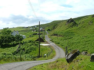
In Scotland a crofting township is a group of agricultural smallholdings (each with its own few hectares of pasture and arable land (in-bye land)) holding in common a substantial tract of unimproved upland grazing. Each township comprises a formal legal unit. Like older Scottish land measurements, such as the davoch, quarterland and oxgang, the extent of a township often varies according to the quality of the land it is on, and this can range from a hundred to a few thousand hectares.[ citation needed ] There is often a substantial tract of unimproved upland common grazing - known as a "shieling" or "àirigh" which is held in common. This tends to be used in the summer, but with the advent of fertilisers it is often used in colder times as well.

In reference to the history of Scotland, a township is often called a toun (the Lowland Scots word for a township), although before the Anglic language Scots became widespread in Scotland the word baile was more commonly used.[ citation needed ]

Traditional townships were largely wiped out during the Highland Clearances. Auchindrain in Argyll, once occupied by up to seven tenant families who farmed the land cooperatively, was the last to survive. This was down to the 19th century landowner, the 8th Duke of Argyll, who decided that splitting the township into individual crofts would not be financially viable and encouraged his tenants to modernise their methods. The final tenant departed Auchindrain in 1963. The traditional houses and other buildings still stand, and have been turned into an open-air museum. [1]

See also

Related Research Articles

<span class="mw-page-title-main">Scottish Highlands</span> Cultural and historical region of Scotland

The Highlands is a historical region of Scotland. Culturally, the Highlands and the Lowlands diverged from the Late Middle Ages into the modern period, when Lowland Scots language replaced Scottish Gaelic throughout most of the Lowlands. The term is also used for the area north and west of the Highland Boundary Fault, although the exact boundaries are not clearly defined, particularly to the east. The Great Glen divides the Grampian Mountains to the southeast from the Northwest Highlands. The Scottish Gaelic name of A' Ghàidhealtachd literally means "the place of the Gaels" and traditionally, from a Gaelic-speaking point of view, includes both the Western Isles and the Highlands.

<span class="mw-page-title-main">Scottish clan</span> Kinship group among the Scottish people

A Scottish clan is a kinship group among the Scottish people. Clans give a sense of shared identity and descent to members, and in modern times have an official structure recognised by the Court of the Lord Lyon, which regulates Scottish heraldry and coats of arms. Most clans have their own tartan patterns, usually dating from the 19th century, which members may incorporate into kilts or other clothing.

Eriskay, from the Old Norse for "Eric's Isle", is an island and community council area of the Outer Hebrides in northern Scotland with a population of 143, as of the 2011 census. It lies between South Uist and Barra and is connected to South Uist by a causeway which was opened in 2001. In the same year Ceann a' Ghàraidh in Eriskay became the ferry terminal for travelling between South Uist and Barra. The Caledonian MacBrayne vehicular ferry travels between Eriskay and Ardmore in Barra. The crossing takes around 40 minutes.

<span class="mw-page-title-main">Scottish Agricultural Revolution</span>

The Agricultural Revolution in Scotland was a series of changes in agricultural practice that began in the 17th century and continued in the 19th century. They began with the improvement of Scottish Lowlands farmland and the beginning of a transformation of Scottish agriculture from one of the least modernised systems to what was to become the most modern and productive system in Europe. The traditional system of agriculture in Scotland generally used the runrig system of management, which had possibly originated in the Late Middle Ages. The basic pre-improvement farming unit was the baile and the fermetoun. In each, a small number of families worked open-field arable and shared grazing. Whilst run rig varied in its detail from place to place, the common defining detail was the sharing out by lot on a regular basis of individual parts ("rigs") of the arable land so that families had intermixed plots in different parts of the field.

<i>Gàidhealtachd</i> Gaelic speaking part of Scotland

The Gàidhealtachd usually refers to the Highlands and Islands of Scotland and especially the Scottish Gaelic-speaking culture of the area. The similar Irish language word Gaeltacht refers, however, solely to Irish-speaking areas.

<span class="mw-page-title-main">Highland Land League</span>

The first Highland Land League emerged as a distinct political force in Scotland during the 1880s, with its power base in the country's Highlands and Islands. It was known also as the Highland Land Law Reform Association and the Crofters' Party. It was consciously modelled on the Irish Land League.

<span class="mw-page-title-main">Crofting</span> Form of land tenure particular to the Scottish Highlands

Crofting is a form of land tenure and small-scale food production particular to the Scottish Highlands, the islands of Scotland, and formerly on the Isle of Man. Within the 19th-century townships, individual crofts were established on the better land, and a large area of poorer-quality hill ground was shared by all the crofters of the township for grazing of their livestock. In the 21st century, crofting is found predominantly in the rural Western and Northern Isles and in the coastal fringes of the western and northern Scottish mainland.

<span class="mw-page-title-main">Highland Potato Famine</span> Major agrarian crisis in the Scottish Highlands from 1846 to 1857

The Highland Potato Famine was a period of 19th-century Highland and Scottish history over which the agricultural communities of the Hebrides and the western Scottish Highlands saw their potato crop repeatedly devastated by potato blight. It was part of the wider food crisis facing Northern Europe caused by potato blight during the mid-1840s, whose most famous manifestation is the Great Irish Famine, but compared with its Irish counterpart, it was much less extensive and took many fewer lives as prompt and major charitable efforts by the rest of the United Kingdom ensured relatively little starvation. The terms on which charitable relief was given, however, led to destitution and malnutrition amongst its recipients. A government enquiry could suggest no short-term solution other than reduction of the population of the area at risk by emigration to Canada or Australia. Highland landlords organised and paid for the emigration of more than 16,000 of their tenants and a significant but unknown number paid for their own passage. Evidence suggests that the majority of Highlanders who permanently left the famine-struck regions emigrated, rather than moving to other parts of Scotland. It is estimated that about a third of the population of the western Scottish Highlands emigrated between 1841 and 1861.

<span class="mw-page-title-main">Crofters Holdings (Scotland) Act 1886</span> United Kingdom legislation

The Crofters Holdings (Scotland) Act 1886 is an Act of the Parliament of the United Kingdom that created legal definitions of crofting parish and crofter, granted security of land tenure to crofters and produced the first Crofters Commission, a land court which ruled on disputes between landlords and crofters. The same court ruled on whether parishes were or were not crofting parishes. In many respects the Act was modelled on the Irish Land Acts of 1870 and 1881. By granting the crofters security of tenure, the Act put an end to the Highland Clearances.

<span class="mw-page-title-main">Croft (land)</span> Small area of agricultural land

A croft is a traditional Scottish term for a fenced or enclosed area of land, usually small and arable, and usually, but not always, with a crofter's dwelling thereon. A crofter is one who has tenure and use of the land, typically as a tenant farmer, especially in rural areas.

<span class="mw-page-title-main">Assynt</span> Sparsely populated area of Sutherland on the west coast of Scotland

Assynt is a sparsely populated area in the south-west of Sutherland, lying north of Ullapool on the west coast of Scotland. Assynt is known for its landscape and its remarkable mountains, which have led to the area, along with neighbouring Coigach, being designated as the Assynt-Coigach National Scenic Area, one of 40 such areas in Scotland.

The davoch, davach or daugh is an ancient Scottish land measurement. All of these terms are cognate with modern Scottish Gaelic dabhach. The word dabh or damh means an "ox", but dabhach can also refer to a "tub", so may indicate productivity. It was called the arachor in the Lennox.

<span class="mw-page-title-main">Coigach</span> Human settlement in Scotland

Coigach is a peninsula north of Ullapool, in Wester Ross in the Northwest Highlands of Scotland. The area consists of a traditional crofting and fishing community of a couple of hundred houses located between mountain and shore on a peninsula looking over the Summer Isles and the sea. The main settlement is Achiltibuie. Like its northerly neighbour, Assynt in Sutherland, Coigach has mountains which rise sharply from quiet, lochan-studded moorland, and a highly indented rocky coast with many islands, bays and headlands. The highest summit is Ben Mor Coigach at 743 metres; the distinctive profile of Stac Pollaidh is the other main peak within Coigach. The scenic qualities of Coigach, along with neighbouring Assynt, have led to the area being designated as the Assynt-Coigach National Scenic Area, one of 40 such areas in Scotland.

A clachan is a small settlement or hamlet on the island of Ireland, the Isle of Man and Scotland. Though many were originally kirktowns, today they are often thought of as small villages lacking a church, post office, or other formal building. It is likely that many date to medieval times or earlier – a cluster of small single-storey cottages of farmers and/or fishermen, invariably found on poorer land. They were often related to the rundale system of farming.

<span class="mw-page-title-main">Boreraig</span> Human settlement in Scotland

Boreraig is a deserted township in Strath Swordale on the north shore of Loch Eishort in the parish of Strath, Isle of Skye, Scotland.

<span class="mw-page-title-main">Auchindrain</span> Human settlement in Scotland

Auchindrain lies on the A83, 6 miles (10 km) south of Inveraray in Argyll and Bute, Scotland. It is the only township to survive substantially unaltered from amongst the many hundreds that existed across the Scottish Highlands before the Highland Clearances of the late 18th and 19th centuries. The major feature of the museum is the 22 buildings and building remains of the township. Twelve of these buildings are mainly complete, with the remains of the other 10 either needing or undergoing restoration work. Much of this work is carried out by volunteers and enthusiasts like the West of Scotland Dry Stone Walling Association.

<span class="mw-page-title-main">Agriculture in Scotland</span> The farming sector of the economy of Scotland

Agriculture in Scotland includes all land use for arable, horticultural or pastoral activity in Scotland, or around its coasts. The first permanent settlements and farming date from the Neolithic period, from around 6,000 years ago. From the beginning of the Bronze Age, about 2000 BCE, arable land spread at the expense of forest. From the Iron Age, beginning in the seventh century BCE, there was use of cultivation ridges and terraces. During the period of Roman occupation there was a reduction in agriculture and the early Middle Ages were a period of climate deterioration resulting in more unproductive land. Most farms had to produce a self-sufficient diet, supplemented by hunter-gathering. More oats and barley were grown, and cattle were the most important domesticated animal. From c. 1150 to 1300, the Medieval Warm Period allowed cultivation at greater heights and made land more productive. The system of infield and outfield agriculture may have been introduced with feudalism from the twelfth century. The rural economy boomed in the thirteenth century, but by the 1360s there was a severe falling off in incomes to be followed by a slow recovery in the fifteenth century.

<span class="mw-page-title-main">Highland Clearances</span> Evictions in Scottish Highlands, 1750–1860

The Highland Clearances were the forced evictions of a significant number of tenants in the Scottish Highlands and Islands, mostly in two phases from 1750 to 1860.

Milovaig, comprises two small scattered, mixed crofting and residential townships, consisting of Lower Milovaig to the North and Upper Milovaig to the South, situated on the south shore of Loch Pooltiel on the Duirinish peninsula, on the Isle of Skye, in the Highlands of Scotland. It is in the Scottish council area of Highland.

Sean, also spelled Seán or Séan in Irish English, is a male given name of Irish origin. It comes from the Irish versions of the Biblical Hebrew name Yohanan, Seán and Séan, rendered John in English and Johannes/Johann/Johan in other Germanic languages. The Norman French Jehan is another version.

References

  1. Campsie, Alison. "The last township that survived the Highland Clearances". The Scotsman. Edinburgh. Retrieved 6 January 2019.