St Columb Major is a town and civil parish in Cornwall, England, United Kingdom. Often referred to locally as St Columb, it is approximately seven miles (11 km) southwest of Wadebridge and six miles (10 km) east of Newquay The designation Major distinguishes it from the nearby settlement and parish of St Columb Minor on the coast. An electoral ward simply named St Columb exists with a population at the 2011 census of 5,050. The town is named after the 6th-century AD Saint Columba of Cornwall, also known as Columb.

Talskiddy is a small rural village about two miles north of St Columb Major in Cornwall, England, United Kingdom. Originally a manorial settlement belonging to the Earldom of Cornwall, the place prospered in the 19th century as a centre of the wool-combing industry.

Boscaswell is a village in the extreme west of Cornwall, England, UK. It lies towards the cliffs from Pendeen, looking west across fields to the Atlantic Ocean. Boscaswell lies within the St Just in Penwith division of Cornwall Council. The village consists mainly of terraced cottages, built of granite, and a council house estate. Many of the cottages would once have housed families whose menfolk worked at the Geevor Tin Mine. Higher Boscaswell is a hamlet south-east of Pendeen.

St Mabyn is a civil parish and village in Cornwall, England, United Kingdom. The village is situated three miles (5 km) east of Wadebridge. The parish includes a hamlet called Longstone to the east and many small manor houses, including Tregarden, Tredethy, Helligan Barton and Colquite, all built in the 16th and 17th centuries. The area of the parish is 4,101 acres (16.60 km2).

St Veep is a civil parish in Cornwall, England, United Kingdom, situated above the east bank of the River Fowey about three miles (5 km) south-east of Lostwithiel. It is bordered by the parishes of St Winnow to the north-west, Boconnoc to the north, Lanreath to the east Polperro to the south-east and Lanteglos to the south. The River Fowey forms its western boundary. The parish is named after Saint Veep of whom little is known.

Crows-an-Wra is a hamlet in West Cornwall, England, United Kingdom. It is situated in the civil parish of St Buryan, Lamorna and Paul approximately four miles (6 km) northeast of Land's End.

St Anthony-in-Meneage is a coastal civil parish and village in Cornwall, England, United Kingdom. The parish is in the Meneage district of the Lizard peninsula. In the 2001 census the parish had a population of 171, decreasing to 168 at the 2011 census.

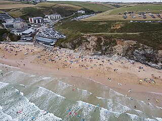
Watergate Bay is a long bay or beach flanked by cliffs centred two miles NNE of Newquay below the B3276 Newquay to Padstow road near the hamlet of Tregurrian in Cornwall, United Kingdom. It faces the Atlantic Ocean, adjacent to Newquay Bay. The 2-mile (3.2 km) sandy beach and exposed site is popular for non-powered water sports, kite flying, and sand art.
High Cross is a hamlet in south Cornwall, England, United Kingdom. It is situated one mile east of Constantine village and approximately four miles (6 km) southwest of Falmouth.
There are seventeen disused railway stations on the Cornish Main Line between Plymouth in Devon and Penzance in Cornwall, England. The remains of nine of these can be seen from passing trains. While a number of these were closed following the so-called "Beeching Axe" in the 1960s, many of them had been closed much earlier, the traffic for which they had been built failing to materialise.

Porth Navas is a small village in Cornwall, England, UK. The village was called "Cove" until the 19th century development as a granite port and is at the head of a short creek running off the main limb which runs north from the Helford River. It is between Mawnan Smith and Constantine within the civil parish of Constantine.

St Breward is a civil parish and village in Cornwall, England, United Kingdom. It is on the western side of Bodmin Moor, about 6 miles (10 km) north of Bodmin. At the 2011 census the parish population including Cooksland and Fentonadle was 919.

Porthoustock is a hamlet near St Keverne in Cornwall, England, United Kingdom, on the east coast of Lizard Peninsula. Aggregates are quarried nearby and Porthoustock beach is dominated by a large concrete stone silo that was once used to store stone ready to load ships but is now disused. Coastal trading ships of up to 82 metres can dock alongside the pier along the southern edge of the beach to be loaded with stone. Fishing boats operate from the pebble beach, with lobster and crab potting, net fishing and hand lines as the principal fishing methods. The South West Coast Path passes through Porthoustock.

Trerulefoot is a village in southeast Cornwall, England, United Kingdom. It is located on the A38 trunk road approximately halfway between the towns of Saltash and Liskeard. Trerulefoot has a farm shop, two cafés and a petrol filling station.

Tremethick Cross is a hamlet around a crossroads in the parish of Madron, in west Cornwall, United Kingdom. Between 1863 and 1884, the A3071 road, was a turnpike serving the mining industry at St Just for the transport of ore to the nearest harbour in Penzance. A toll house, two miles west of Penzance, can still be seen on the crossroads.

Slaughterbridge, Treague and Camelford Station are three adjoining settlements in north Cornwall, England. They straddle the boundary of Forrabury and Minster and Lanteglos by Camelford civil parishes just over a mile (2 km) north-west of the market town of Camelford.

Lanteglos is a coastal civil parish in south Cornwall, England, United Kingdom. It is on the east side of the tidal estuary of the River Fowey which separates it from the town and civil parish of Fowey. The South West Coast Path runs along the southern coasts of the parish and much of the southern part of the parish lies in the Polruan to Polperro Site of Special Scientific Interest managed by the National Trust.

Carnebone is a small hamlet and farm in the parish of Wendron in Cornwall, England. It lies to the east of Wendron, to the northeast of Trevenen, just to the west of Seworgan, along the A394 road, 3.8 miles (6.1 km) northeast of Helston.

Roseworthy is a hamlet on the A30 trunk road in the parish of Gwinear-Gwithian in Cornwall, England, UK.

Tregidden is a hamlet south of Manaccan in Cornwall, England, United Kingdom. A little further south is Tregidden Farm. Tregidden is located in the parish of St Martin-in-Meneage and also partly in the parishes of Manaccan and St Keverne.


