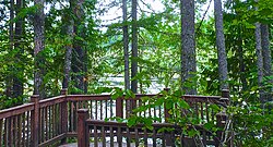
Issaquah is a city in King County, Washington, United States. The population was 40,051 at the 2020 census. Located in a valley and bisected by Interstate 90, the city is bordered by the Sammamish Plateau to the north and the "Issaquah Alps" to the south. It is home to the headquarters of the multinational retail company Costco. Issaquah is included in the Seattle metropolitan area.

Mount Si is a mountain in the northwest United States, east of Seattle, Washington. It lies on the western margin of the Cascade Range just above the coastal plains around Puget Sound, and towers over the nearby town of North Bend. Mount Si and neighboring mountain Little Si were named after local homesteader Josiah "Uncle Si" Merritt. The mountain became nationally familiar in the early 1990s with the television series Twin Peaks, which was filmed in North Bend.

The Issaquah Alps is the unofficial name for the highlands near Issaquah, Washington, a suburb of Seattle, including Cougar Mountain, Squak Mountain, Tiger Mountain, Taylor Mountain, Rattlesnake Ridge, Rattlesnake Mountain, and Grand Ridge. The term was invented in 1977 by noted nature author Harvey Manning within the pages of his trail guidebook Footsore 1, elevating their status from foothills to "Alps" to advocate preservation. Manning himself lived on a developed section of Cougar Mountain in his "200 meter hut".

Oak Mountain State Park is a public recreation area located approximately 20 miles (32 km) south of Birmingham in the northeast quadrant of the city of Pelham, Alabama, United States. It is the state's largest state park at 9,940 acres (4,020 ha) and is home to the Alabama Wildlife Center, Oak Mountain Interpretive Center, and Oak Mountain BMX Track. Park activities include hiking, running, mountain biking, swimming, camping, fishing, horseback riding, and golf. The park is managed by the Alabama Department of Conservation and Natural Resources.
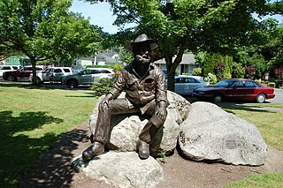
Harvey Manning was a noted author of hiking guides and climbing textbooks, and a tireless hiking advocate. Manning lived on Cougar Mountain, within the city limits of Bellevue, Washington, calling his home the "200-meter hut". His book Walking the Beach to Bellingham is an autobiography and manifesto fleshing out his journal of a hike along the shore of Puget Sound over a two-year span.

Savanna Portage State Park is a state park in the U.S. State of Minnesota established in 1961 to preserve the historic Savanna Portage, a difficult 6-mile (9.7 km) trail connecting the watersheds of the Mississippi River and Lake Superior. The portage trail crosses a drainage divide separating the West Savanna River, which drains to the Mississippi River and the Gulf of Mexico, from the East Savanna River, which flows in an opposite direction to the Saint Louis River, Lake Superior and the Great Lakes, and the Saint Lawrence River to the Atlantic Ocean.

Cougar Mountain Regional Wildland Park is a regional park in King County, Washington, near the towns of Bellevue and Issaquah. The park was established in June 1983 to protect the central core of Cougar Mountain, the park covers 3,115 acres (12.61 km2) with 38 miles (61 km) of hiking trails and 12 miles (19 km) of equestrian trails.
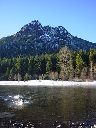
Rattlesnake Ridge, known as daʔšədabš to the Snoqualmie people, is the ridge of Rattlesnake Mountain located south of North Bend, Washington, United States. The western end is near the intersection of State Route 18 and I-90 in Snoqualmie, Washington, and runs southeast about 7 miles (11 km) or 11 miles (18 km) by trail. It is the highest and easternmost of the Issaquah Alps. A maze of abandoned logging roads and constructed trails have been strung together to provide a 10.5-mile (16.9 km) footpath from the Snoqualmie Point trailhead at Exit 27 on I-90 all the way to the Rattlesnake Lake trailhead near Exit 32.

Squak Mountain is the second most westerly mountain of the Issaquah Alps mountain chain in Washington state. It is situated between Cougar Mountain to the west and Tiger Mountain to the east. Interstate 90 parallels the base of the north side of the mountain. Much of the Squak Mountain watershed drains into Lake Sammamish. Most of the mountain is protected by Squak Mountain State Park and the Cougar/Squak and Squak/Tiger Corridors of King County.

Tiger Mountain is a mountain in the U.S. state of Washington. It is at the center of the Issaquah Alps, a small range in the Eastside region of King County, Washington southeast of Seattle. The mountain is part of a designated protected area, the Tiger Mountain State Forest, and has several recreational areas used for hiking, mountain biking, and paragliding.
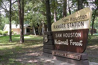
The Sam Houston National Forest, one of four National Forests in Texas, is located 50 miles north of Houston. The forest is administered together with the other three United States National Forests and two National Grasslands located entirely in Texas, from common offices in Lufkin, Texas. The units include Angelina, Davy Crockett, Sabine, and Sam Houston National Forests, plus Caddo National Grassland and Lyndon B. Johnson National Grassland. There are local ranger district offices located in New Waverly. It is located in portions of three Texas counties including Montgomery, San Jacinto, and Walker.

Vogel State Park is a 233-acre (0.94 km2) or 94 hectares state park located at the base of Blood Mountain in the Chattahoochee National Forest. It became one of the first two parks in Georgia when it founded a state park system in 1931. Much of the park was constructed by the Civilian Conservation Corps during the 1930s.

Sinnemahoning State Park is a 1,910-acre (773 ha) Pennsylvania state park in Grove Township, Cameron County and Wharton Township, Potter County, Pennsylvania, in the United States. The park is surrounded by Elk State Forest and is mountainous with deep valleys. The park is home to the rarely seen elk and bald eagle. Sinnemahoning State Park is on Pennsylvania Route 872, eight miles (13 km) north of the village of Sinnamahoning. In 1958, the park opened under the direction of the Pennsylvania Bureau of Forestry: it became a Pennsylvania State Park in 1962.

Issaquah Creek is a small stream flowing through the city of Issaquah and nearby communities, in the U.S. state of Washington. Its headwaters are on the slopes of Cougar, Squak, Tiger, and Taylor mountains in the Issaquah Alps. Tributaries of Issaquah Creek include Holder Creek, Carey Creek, Fifteen-mile Creek, McDonald Creek, East Fork Issaquah Creek, and North Fork Issaquah Creek. The creek empties into the south end of Lake Sammamish. The lake's outlet is the Sammamish River, which in turn empties into Lake Washington and ultimately Puget Sound.
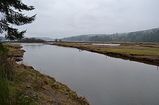
Kennedy Creek Natural Area Preserve is a state-protected Natural Area near US Highway 101 on Oyster Bay, Puget Sound, in southwest Washington state, United States. The preserve is on the border of Thurston County and Mason County and contains 203 acres (82 ha) of intertidal salt marsh and upland forest.
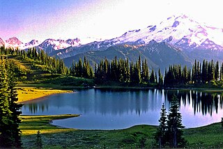
Image Lake is a tarn in Glacier Peak Wilderness, in the North Cascades of Washington, United States. The lake is surrounded by Plummer Peak to the east, a lookout point to the west, the Miners Creek drainage and Glacier Peak to the south, and Canyon Lake to the north. The course of the popular Miners Ridge Trail skirts the lake. Glacier Peak can be seen from the outlet of the lake, and the peak reflected in the lake is a popular photographic subject.

Glacial erratic boulders of King County are large glacial erratic boulders of rock which were moved into King County, Washington by glacial action during previous ice ages.

The Dutchmans Stern Conservation Park is a protected area located in South Australia about 5 kilometres north-west of the town of Quorn in the Flinders Ranges. It includes a mountain known as The Dutchmans Stern from which its name is derived.
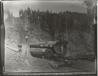
High Point is an unincorporated community in King County, in the U.S. state of Washington.
Hills in the Puget Lowland, between the Cascades and the Olympic Mountains, including the entire Seattle metropolitan area, are generally between 350–450 feet (110–140 m) and rarely more than 500 feet (150 m) above sea level. Hills are often notable geologically and for social reasons, such as the seven hills of Seattle.
