Related Research Articles

The N1 is a national route in South Africa that runs from Cape Town through Bloemfontein, Johannesburg, Pretoria and Polokwane to Beit Bridge on the border with Zimbabwe. It forms the first section of the famed Cape to Cairo Road.

The Swartberg mountains are a mountain range in the Western Cape province of South Africa. It is composed of two main mountain chains running roughly east–west along the northern edge of the semi-arid Little Karoo. To the north of the range lies the other large semi-arid area in South Africa, the Great Karoo. Most of the Swartberg Mountains are above 2000 m high, making them the tallest mountains in the Western Cape. It is also one of the longest, spanning some 230 km from south of Laingsburg in the west to between Willowmore and Uniondale in the east. Geologically, these mountains are part of the Cape Fold Belt.
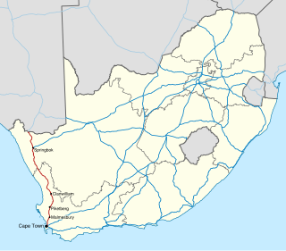
The R324 is a Regional Route in South Africa that connects Barrydale to the north with Port Beaufort and Witsand to the south.

The N2 is a national route in South Africa that runs from Cape Town through George, Gqeberha, East London, Mthatha, Port Shepstone and Durban to Ermelo. It is the main highway along the Indian Ocean coast of the country. Its current length of 2,255 kilometres (1,401 mi) makes it the longest numbered route in South Africa.

The Langeberg Range is a mountain range in the Western Cape province of South Africa. Its highest peak is Keeromsberg at 2,075 m that lies 15 km northeast of the town of Worcester. Some of the highest peaks of the range are located just to the north of Swellendam, in a subrange known as the Clock Peaks whose highest point is the 1,710 m high Misty Point. Local lore states one can tell the time by means of the shadows cast by the seven summits of the Clock Peaks.

Barrydale is a village located on the border of the Overberg and Klein Karoo regions of the Western Cape Province in South Africa. It was named after Joseph Barry, a well-known merchant of the 19th century. It is situated at the northern end of the Tradouws Pass which winds its way through the mountains to Swellendam.
The N7 is a national route in South Africa that runs from Cape Town northwards through the West Coast and Namaqualand regions to the Namibian border at Vioolsdrif. After crossing the border, it changes designation to B1 and runs north through Windhoek and the north of Namibia.

The N12 is a national route in South Africa which runs from George through Beaufort West, Kimberley, Klerksdorp and Johannesburg to eMalahleni.
The Tripoli–Cape Town Highway or TAH 3 is Trans-African Highway 3 in the transcontinental road network being developed by the United Nations Economic Commission for Africa (UNECA), the African Development Bank (AfDB), and the African Union. The route has a length of 10,808 km (6,716 mi) and has the longest missing links and requires the most new road construction.

Sir Lowry's Pass is a mountain pass on the N2 national road in the Western Cape province of South Africa. It crosses the Hottentots Holland Mountains between Somerset West and the Elgin valley, on the main route between Cape Town and the Garden Route. A railway line also crosses the mountain range near this point.

The N9 is a national route in South Africa that connects George with the N1 at Colesberg, via Graaff-Reinet and Middelburg.

The R62 is a provincial route in South Africa that connects Ashton with Humansdorp. The R62 runs through the Little Karoo and the Langkloof, passing through Montagu, Ladismith, Calitzdorp, Oudtshoorn, and Joubertina.
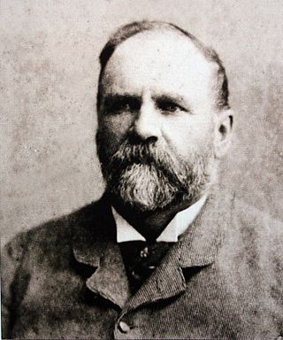
Thomas Charles John Bain was a South African road engineer. As a prolific road building pioneer, Bain was responsible for the planning and construction of more than 900 km of roads and mountain passes, many of them still in use today, over a career spanning from 1848 until 1888. These passes through the mountain ranges between the thin coastal plain and the interior of the former Cape Colony in South Africa, played a major role in opening up the vast hinterland of South Africa.

The Cairo–Cape Town Highway is Trans-African Highway 4 in the transcontinental road network being developed by the United Nations Economic Commission for Africa (UNECA), the African Development Bank (AfDB), and the African Union. The route has a length of 10,228 km (6,355 mi) and links Cairo in Egypt to Cape Town in South Africa.

Touws River is a small railway town of 6,800 people in the Western Cape province of South Africa. It is located on the river of the same name, about 160 kilometres (100 mi) north-east of Cape Town. The Touwsrivier CPV Solar Project is located just outside of the town and supplies 50 MW to the national electrical grid.

Philadelphia is a village in the Western Cape province of South Africa.

Ou Kaapse Weg, numbered as route M64, is a mountain pass in the Cape Peninsula that connects the Southern Suburbs of Cape Town with the Fish Hoek Valley. It traverses the Steenberg mountains and passes through the Silvermine Nature Reserve. Ou Kaapse Weg is one of three routes to the Fish Hoek Valley: the others are Chapman's Peak Drive along the Atlantic coast and Main Road along the False Bay coast. Despite its name, the pass was only constructed in 1968, by the Divisional Council of the Cape.

Grootvadersbosch is a historic farm in the Overberg, and the surrounding area is currently a nature reserve in the southern portion of the Boosmansbos Wilderness Area, in Western Cape, South Africa.

The M9 is a long metropolitan route in the City of Cape Town, South Africa. It connects Sir Lowry's Pass Village with Wynberg via Somerset West, Firgrove, Macassar, Khayelitsha and Nyanga.
The M10 is a metropolitan route in the City of Cape Town Metropolitan Municipality, South Africa. It connects the town of Bellville in the Northern Suburbs with Philippi on the Cape Flats.