Tramlink route 5

Last updated
Route 5
Overview
System Tramlink
Operator London Tramlink
Depot Therapia Lane
Route
Locale Croydon, England
Start Crystal Palace
End West Croydon
Service
Level Daily (six trams per hour)
Frequency About every 8 minutes (proposed)

Tramlink Route 5 was a proposed tram route that would have been operated as part of the Tramlink network in south London. The route would have been operated by Transport for London.

Tramlink light rail system in London, United Kingdom

London Trams, previously Tramlink and Croydon Tramlink, is a light rail tram system serving Croydon and surrounding areas in South London, England. It began operation in 2000, the first tram system in London since 1952. It is owned by London Trams, an arm of Transport for London (TfL), and operated by Tram Operations Ltd. a subsidiary of FirstGroup.

Transport for London local government body responsible for the transport system in Greater London

Transport for London (TfL) is a local government body responsible for the transport system in Greater London, England. Its head office is 55 Broadway in the City of Westminster.

Contents

Background

The proposed route would have linked Harrington Road stop with Crystal Palace, and Crystal Palace directly with Beckenham Junction, both terminating at Crystal Palace Parade. [1] There were three options on how to get to the Parade: on-street, off-street and a mixture of the two. After consultation in 2006 the off-street option was favoured, with trams running along existing railway as far as Crystal Palace Station, and then running round the western edge of Crystal Palace Park (within the current park's perimeter) to the bus terminus near the parade. The planned extension was cancelled due to a lack of funding in 2000. The plans were revived shortly after Boris Johnson's re-election as London mayor in May 2012 but six months later the plan was cancelled again. [2]

Crystal Palace, London Residential area in London, United Kingdom

Crystal Palace is an area in South London, England, named after the Crystal Palace Exhibition building which stood in the area from 1854 until it was destroyed by fire in 1936. Approximately 7 miles southeast of Charing Cross, it includes one of the highest points in London, at 367 feet (112 m), offering views over the capital. The area has no defined boundaries and straddles five London boroughs and three postal districts, although there is a Crystal Palace electoral ward and Crystal Palace Park in the London Borough of Bromley. It is contiguous with Anerley, Dulwich Wood, Gipsy Hill, Penge, South Norwood, Sydenham and Upper Norwood.

Crystal Palace railway station railway station

Crystal Palace railway station is a Network Rail and London Overground station in the London Borough of Bromley in south London. It is located in the Anerley area between the town centres of Crystal Palace and Penge, 8 miles 56 chains (14.0 km) from London Victoria. It is one of two stations built to serve the site of the 1851 exhibition building, the Crystal Palace, when it was moved from Hyde Park to Sydenham Hill after 1851.

Crystal Palace Park Victorian pleasure ground in Crystal Palace, Bromley, London

Crystal Palace Park is a Victorian pleasure ground, used for cultural and sporting events. It is located in the south-east London suburb of Crystal Palace, which was in turn named after the Crystal Palace Exhibition building, which had been moved from Hyde Park, London after the 1851 Great Exhibition and rebuilt with some modifications and enlargements to form the centrepiece of the pleasure ground, before being destroyed by fire in 1936. The park features full-scale models of dinosaurs in a landscape, a maze, lakes, and a concert bowl.

Current Route

A tram at the Beckenham Junction terminus for Route 2 Beckenham Junction tramstop look west with Tram 2543.JPG
A tram at the Beckenham Junction terminus for Route 2
Route 5 (proposed)
Beckenham Junction station combined railway station and a tram terminus in Beckenham, Bromley, London

Beckenham Junction is the main railway and tram station in Beckenham in the London Borough of Bromley, south London. The railway stop is on the Chatham Main Line, 8 miles 53 chains (13.9 km) down the line from London Victoria and situated between Kent House and Shortlands. The tram stop is the eastern terminus of Tramlink.

Beckenham Road tram stop

Beckenham Road tram stop is a light rail stop in the London Borough of Bromley in the southern suburbs of London. The stop is located on an embankment above Beckenham Road (A234) which connects Beckenham with Crystal Palace and Penge on the site of the short-lived (1858–1860) West End of London & Crystal Palace Railway Penge station.

Avenue Road tram stop

Avenue Road tram stop is a light rail stop in the London Borough of Bromley in the southern suburbs of London. It is located on Avenue Road in a mainly residential area between Penge and Beckenham.

Then back to Penge Road

Harrington Road tram stop

Harrington Road tram stop is a light rail stop in South Norwood in the London Borough of Croydon in the southern suburbs of London. Harrington Road is in a residential area, and along with Woodside tram stop is the nearest tram stop to the town of South Norwood. Beckenham Cemetery lies immediately to the east and there is an entrance immediately adjacent to the tramstop.

Woodside tram stop

Woodside tram stop is a light rail stop situated between Woodside Green and Ashburton Park in the London Borough of Croydon in the southern suburbs of London. The stop is located on the site of the former Woodside railway station of the Woodside and South Croydon Railway; the old station buildings survive, though not used by Tramlink.

Blackhorse Lane tram stop tramstop in Croydon, UK

Blackhorse Lane tram stop is a light rail stop in the London Borough of Croydon in the southern suburbs of London.

Then to East Croydon and back to Beckenham Junction or Crystal Palace

Related Research Articles

Mitcham Junction station

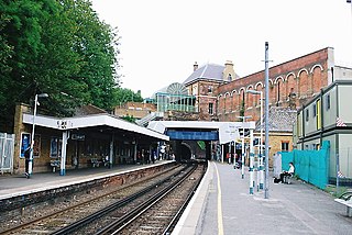
Mitcham Junction is a National Rail station served by Southern and Thameslink trains, and a Tramlink stop. It is in the London Borough of Merton and is in Travelcard Zone 4.

Wimbledon station National rail, London Underground and tram station

Wimbledon is a National Rail, London Underground, and Tramlink station located on Wimbledon Bridge, Wimbledon in London, and is the only London station that provides an interchange between main line rail, Underground, and Tramlink. The station serves as a junction for services from the Underground's District line and National Rail operators, as well as Tramlink services. Some early morning services on the Thameslink route are provided by Southern. The station is in Travelcard Zone 3. It is 7 miles 19 chains (11.6 km) from London Waterloo on the South Western main line.

Birkbeck station railway station and tramstop in London Borough of Bromley, UK

Birkbeck is a railway station and light rail stop in the London Borough of Bromley in the southern suburbs of London. On the rail network it is 10 miles 26 chains (16.6 km) measured from London Victoria. It is located on Elmers End Road (A214) and alongside Beckenham Crematorium.

South Wimbledon tube station London Underground station

South Wimbledon is a London Underground station in South Wimbledon, a suburb of Wimbledon in south-west London. The station is on the Northern line, situated between Colliers Wood and Morden stations. It is located on the corner of Merton High Street (A238) and Morden Road (A219). South Wimbledon is on the boundary between Travelcard Zone 3 and Zone 4.

Trams in London Tram system in London, United Kingdom

There have been two separate generations of trams in London, from 1860 to 1952 and from 2000 to the present. There were no trams at all in London between 1952 and 2000.

West Croydon station transport interchange in Croydon, London

West Croydon is a combined railway, bus station and tram stop in Croydon, south London. It is served by National Rail, London Overground, Tramlink and London Buses services and is in Travelcard Zone 5.

Woodside and South Croydon Joint Railway

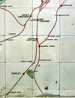
The Woodside and South Croydon Joint Railway (W&SC) was a short, relatively short-lived and unsuccessful railway in the London Borough of Croydon in London, England. Its site is now largely occupied by Tramlink.

Sutton railway station (London) station in London

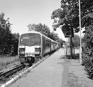
Sutton railway station is in the London Borough of Sutton in south London and is the main station serving Sutton town. It is served by Southern and Thameslink trains, and lies in Travelcard Zone 5, 14 miles 75 chains (24.04 km) down the line from London Bridge, measured via Forest Hill.

Tramlink route 1

Tramlink route 1 is one of four tram routes operated as part of the Tramlink network in south London. The route is owned and operated by Transport for London (TfL).

Addiscombe tram stop

Addiscombe tram stop is a light rail stop in the London Borough of Croydon in the southern suburbs of London.

Morden Road tram stop

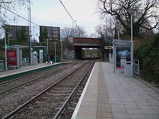
Morden Road tram stop is a stop on the Tramlink service in the London Borough of Merton. It is on the site of the former Morden Road railway station on the Wimbledon-West Croydon line, which closed to rail traffic in 1997.

Ampere Way tram stop

Ampere Way is a tram stop in the London Borough of Croydon, serving the Purley Way commercial area. Tramlink trams serve the stop, which is located opposite IKEA Croydon.

Tramlink route 2

Tramlink route 2 is one of four tram routes operated as part of the Tramlink network in south London. The route is owned and operated by Transport for London (TfL).

Merton Park railway station

Merton Park railway station was a railway station in Merton, Surrey, serving both the West Croydon to Wimbledon Line and the Tooting, Merton and Wimbledon Railway. Closed in 1997, part of the site now serves as a tram stop on the New Addington to Wimbledon line of the Tramlink network.

Sutton Loop Line

The Sutton Loop Line, also known as the Wimbledon Loop, is part of Thameslink and is the circular route formed where the St Helier line diverges from the Portsmouth Line at Streatham South junction and rejoins it near Sutton station. Trains leave southwards from Streatham to enter the loop and then return going northwards. The short section between West Sutton station and West junction is known as the "Wall of Death", possibly due to the very steep concrete walls to the cutting on both sides and the sharpness of the curve which resemble the motorcycle ride at a funfair.

London Trams refers to the arm of Transport for London (TfL) that manages Tramlink and future tram projects in Greater London, England.

2016 Croydon tram derailment November 2016 fatal derailment in south London

On 9 November 2016, a tram operated by Tramlink, a light rail tram system serving Croydon and surrounding areas in South London, England, derailed and overturned on a sharp bend approaching a junction. There were seven fatalities with 62 other people injured; nineteen of them sustained serious injuries. The tram was carrying 69 passengers. It was the first tram incident in the United Kingdom in which passengers were killed since 1959.

The Sutton Link is a planned new Tramlink line or separate bus rapid transit (BRT) in London, between Wimbledon/or Colliers Wood via St Helier to Sutton. It may be owned by London Trams or a separate body, which would be an arm of Transport for London (TfL)

References

  1. "Croydon Tramlink extension to Crystal Palace". Lambeth Council Website. Lambeth Council. Retrieved 19 August 2013.
  2. Austen, Ian (7 December 2012). "Crystal Palace Tramlink extension not backed by Boris Johnson despite manifesto". Croydon Advertiser. Retrieved 19 August 2013.