
Geophysics is a subject of natural science concerned with the physical processes and physical properties of the Earth and its surrounding space environment, and the use of quantitative methods for their analysis. The term geophysics sometimes refers only to geological applications: Earth's shape; its gravitational and magnetic fields; its internal structure and composition; its dynamics and their surface expression in plate tectonics, the generation of magmas, volcanism and rock formation. However, modern geophysics organizations and pure scientists use a broader definition that includes the water cycle including snow and ice; fluid dynamics of the oceans and the atmosphere; electricity and magnetism in the ionosphere and magnetosphere and solar-terrestrial relations; and analogous problems associated with the Moon and other planets.

Electromagnetic or magnetic induction is the production of an electromotive force across an electrical conductor in a changing magnetic field.

A magnetometer is a device that measures magnetism—the direction, strength, or relative change of a magnetic field at a particular location. The measurement of the magnetization of a magnetic material is an example. A compass is one such device, one that measures the direction of an ambient magnetic field, in this case, the Earth's magnetic field.
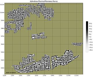
In archaeology, geophysical survey is ground-based physical sensing techniques used for archaeological imaging or mapping. Remote sensing and marine surveys are also used in archaeology, but are generally considered separate disciplines. Other terms, such as "geophysical prospection" and "archaeological geophysics" are generally synonymous.
A telluric current, or Earth current, is an electric current which moves underground or through the sea. Telluric currents result from both natural causes and human activity, and the discrete currents interact in a complex pattern. The currents are extremely low frequency and travel over large areas at or near the surface of the Earth.

Prospecting is the first stage of the geological analysis of a territory. It is the search for minerals, fossils, precious metals or mineral specimens, and is also known as fossicking.
Exploration geophysics is an applied branch of geophysics and economic geology, which uses physical methods, such as seismic, gravitational, magnetic, electrical and electromagnetic at the surface of the Earth to measure the physical properties of the subsurface, along with the anomalies in those properties. It is most often used to detect or infer the presence and position of economically useful geological deposits, such as ore minerals; fossil fuels and other hydrocarbons; geothermal reservoirs; and groundwater reservoirs.
Eddy-current testing is one of many electromagnetic testing methods used in nondestructive testing (NDT) making use of electromagnetic induction to detect and characterize surface and sub-surface flaws in conductive materials.

Magnetotellurics (MT) is an electromagnetic geophysical method for inferring the earth's subsurface electrical conductivity from measurements of natural geomagnetic and geoelectric field variation at the Earth's surface. Investigation depth ranges from 300 m below ground by recording higher frequencies down to 10,000 m or deeper with long-period soundings. Proposed in Japan in the 1940s, and France and the USSR during the early 1950s, MT is now an international academic discipline and is used in exploration surveys around the world. Commercial uses include hydrocarbon exploration, geothermal exploration, carbon sequestration, mining exploration, as well as hydrocarbon and groundwater monitoring. Research applications include experimentation to further develop the MT technique, long-period deep crustal exploration, deep mantle probing, and earthquake precursor prediction research.
Geophysical survey is the systematic collection of geophysical data for spatial studies. Detection and analysis of the geophysical signals forms the core of Geophysical signal processing. The magnetic and gravitational fields emanating from the Earth's interior hold essential information concerning seismic activities and the internal structure. Hence, detection and analysis of the electric and Magnetic fields is very crucial. As the Electromagnetic and gravitational waves are multi-dimensional signals, all the 1-D transformation techniques can be extended for the analysis of these signals as well. Hence this article also discusses multi-dimensional signal processing techniques.

An aeromagnetic survey is a common type of geophysical survey carried out using a magnetometer aboard or towed behind an aircraft. The principle is similar to a magnetic survey carried out with a hand-held magnetometer, but allows much larger areas of the Earth's surface to be covered quickly for regional reconnaissance. The aircraft typically flies in a grid-like pattern with height and line spacing determining the resolution of the data.

Geophysical imaging is a minimally destructive geophysical technique that investigates the subsurface of a terrestrial planet. Geophysical imaging is a noninvasive imaging technique with a high parametrical and spatio-temporal resolution. Geophysical imaging has evolved over the last 30 years due to advances in computing power and speed. It can be used to model a surface or object understudy in 2D or 3D as well as monitor changes.
Induced polarization (IP) is a geophysical imaging technique used to identify the electrical chargeability of subsurface materials, such as ore.

Geothermal exploration is the exploration of the subsurface in search of viable active geothermal regions with the goal of building a geothermal power plant, where hot fluids drive turbines to create electricity. Exploration methods include a broad range of disciplines including geology, geophysics, geochemistry and engineering.

Near-surface geophysics is the use of geophysical methods to investigate small-scale features in the shallow subsurface. It is closely related to applied geophysics or exploration geophysics. Methods used include seismic refraction and reflection, gravity, magnetic, electric, and electromagnetic methods. Many of these methods were developed for oil and mineral exploration but are now used for a great variety of applications, including archaeology, environmental science, forensic science, military intelligence, geotechnical investigation, treasure hunting, and hydrogeology. In addition to the practical applications, near-surface geophysics includes the study of biogeochemical cycles.
The following outline is provided as an overview of and topical guide to geophysics:
Hydrogeophysics is a cross-disciplinary area of research that uses geophysics to determine parameters and monitor processes for hydrological studies of matters such as water resources, contamination, and ecological studies. The field uses knowledge and researchers from geology, hydrology, physics, geophysics, engineering, statistics, and rock physics. It uses geophysics to provide quantitative information about hydrogeological parameters, using minimally invasive methods. Hydrogeophysics differs from geophysics in its specific uses and methods. Although geophysical knowledge and methods have existed and grown over the last half century for applications in mining and petroleum industries, hydrogeological study sites have different subsurface conditions than those industries. Thus, the geophysical methods for mapping subsurface properties combine with hydrogeology to use proper, accurate methods to map shallow hydrological study sites.
EMIGMA is a geophysics interpretation software platform developed by Petros Eikon Incorporated for data processing, simulation, inversion and imaging as well as other associated tasks. The software focuses on non-seismic applications and operates only on the Windows operating system. It supports files standard to the industry, instrument native formats as well as files used by other software in the industry such as AutoCAD, Google Earth and Oasis montaj. There is a free version of EMIGMA called EMIGMA Basic developed to allow viewing of databases created by licensed users. It does not allow data simulation nor modeling nor data import. The software is utilized by geoscientists for exploration and delineating purposes in mining, oil and gas and groundwater as well as hydrologists, environmental engineers, archaeologists and academic institutions for research purposes. Principal contributors to the software are R. W. Groom, H. Wu, E. Vassilenko, R. Jia, C. Ottay and C. Alvarez.
Surface nuclear magnetic resonance (SNMR), also known as magnetic resonance Sounding (MRS), is a geophysical technique specially designed for hydrogeology. It is based on the principle of nuclear magnetic resonance (NMR) and measurements can be used to indirectly estimate the water content of saturated and unsaturated zones in the earth's subsurface. SNMR is used to estimate aquifer properties, including the quantity of water contained in the aquifer, porosity, and hydraulic conductivity.
Alexander Peter Annan is an engineer whose research focuses on near-surface geophysics. He has made significant contributions to the development of ground-penetrating radar (GPR) technology. Annan is the CEO of Sensors & Software, a company he founded to commercialize GPR technology. He has been working on the development of GPR since the 1970s and was one of the lead researchers on the surface electrical properties experiment conducted on the Moon during the Apollo 17 mission.
