
Franklin County is located in the Blue Ridge foothills of the Commonwealth of Virginia. As of the 2020 census, the population was 54,477. Its county seat is Rocky Mount. Franklin County is part of the Roanoke Metropolitan Statistical Area and is located in the Roanoke Region of Virginia. The Roanoke River forms its northeast boundary with Bedford County.
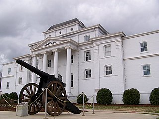
Wilkes County is a county located in the U.S. state of North Carolina. It is a part of the state's western mountain region. As of the 2020 census the population was 65,969. Its county seat is Wilkesboro, and its largest community is North Wilkesboro. Wilkes County comprises the North Wilkesboro, NC Micropolitan Statistical Area.

North Wilkesboro is a town in Wilkes County, North Carolina, United States. The population was 4,131 at the 2020 US Census. North Wilkesboro is the birthplace and original home of Lowe's Home Improvement, which continues to have a major presence in the community. The town is also known as one of the birthplaces of the sport of stock-car racing, and the North Wilkesboro Speedway was the first NASCAR-sanctioned track. Due to the town's proximity to the nearby Blue Ridge Mountains and its numerous tourist venues, North Wilkesboro has been nicknamed the "Key to the Blue Ridge".
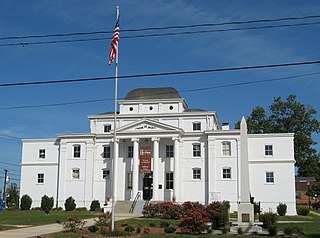
Wilkesboro is a town in and the county seat of Wilkes County, North Carolina, United States. The population was 3,687 at the 2020 census. The town is located along the south bank of the Yadkin River, directly opposite the town of North Wilkesboro. Wilkesboro is a Small Town Main Street community and has recently revitalized its historic downtown to include the Carolina West Wireless Community Commons, Wilkes Communications Pavilion, Heritage Square and Splash Pad. Cub Creek Park is adjacent to the downtown and contains many amenities, which include baseball, walking trails, mountain biking trails, trout fishing, dog park, basketball, tennis, and pickleball courts, picnic shelters, etc. Wilkesboro is also the home of the annual MerleFest, Carolina in the Fall, and Brushy Mountain Peach & Heritage festivals.

Newport is a city in and the county seat of Cocke County, Tennessee, United States. The population was 6,945 at the 2010 census, down from 7,242 at the 2000 census. The estimated population in 2018 was 6,801. Newport is located along the Pigeon River.

Blowing Rock is a town in Watauga and Caldwell counties in the U.S. state of North Carolina. The population was 1,397 at the 2021 census.

The Shenandoah Valley is a geographic valley and cultural region of western Virginia and the Eastern Panhandle of West Virginia in the United States. The Valley is bounded to the east by the Blue Ridge Mountains, to the west by the eastern front of the Ridge-and-Valley Appalachians, to the north by the Potomac River, and to the south by the James River. The cultural region covers a larger area that includes all of the Valley plus the Virginia Highlands to the west and the Roanoke Valley to the south. It is physiographically located within the Ridge and Valley Province and is a portion of the Great Appalachian Valley.
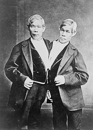
Chang Bunker and Eng Bunker were Siamese (Thai)-American conjoined twin brothers whose fame propelled the expression "Siamese twins" to become synonymous for conjoined twins in general. They were widely exhibited as curiosities and were "two of the nineteenth century's most studied human beings".

Lookout Mountain is a mountain ridge located at the northwest corner of the U.S. state of Georgia, the northeast corner of Alabama, and along the southeastern Tennessee state line in Chattanooga. Lookout Mountain was the scene of the 18th-century "Last Battle of the Cherokees" in this area during the Nickajack Expedition. On November 24, 1863, during the American Civil War, the Battle of Lookout Mountain took place here.

The Brushy Mountains are a mountain range located in northwestern North Carolina. They are an isolated "spur" of the much larger Blue Ridge Mountains, separated from them by the Yadkin River valley. A deeply eroded range, they move from the southwest to the northeast, and cross five counties in North Carolina: Caldwell, Alexander, Wilkes, Iredell, and Yadkin.

Ashby Gap, more commonly known as Ashby's Gap is a wind gap in the Blue Ridge Mountains on the border of Clarke County, Loudoun County and Fauquier County in Virginia. The gap is traversed by U.S. Route 50. The Appalachian trail also passes across the gap.
The Roaring River is a tributary of the Yadkin River in northwestern North Carolina in the United States. Via the Yadkin it is part of the watershed of the Pee Dee River, which flows to the Atlantic Ocean. According to the Geographic Names Information System, it has also been known historically as "Roaring Creek." The river's name comes from its headwaters in the Blue Ridge Mountains, where it flows through a series of small waterfalls.

The Sugarlands is a valley in Tennessee within the north-central Great Smoky Mountains, located in the southeastern United States. Formerly home to a string of small Appalachian communities, the valley is now the location of the Great Smoky Mountains National Park headquarters and the Sugarlands Visitor Center. Lying just south of Gatlinburg, the Sugarlands is one of the park's most popular access points.

Cosby is a census-designated place (CDP) and unincorporated community in Cocke County in the U.S. state of Tennessee. The population of the Cosby CDP according to the 2020 census was 807. The community has given its name to the northeastern section of the Great Smoky Mountains National Park, which forms its southern boundary. Cosby's zip code also extends to into Sevier County, and borders the town of Pittman Center.

Roaring Gap is an unincorporated community in the Cherry Lane Township of Alleghany County, North Carolina, United States, situated near the border with Wilkes County. Home to three private golf communities, Roaring Gap is a popular summer colony.
Greenbrier is a valley in the northern Great Smoky Mountains of Tennessee, located in the southeastern United States. Now a recreational area located within the Great Smoky Mountains National Park, Greenbrier was once home to several Appalachian communities.

Cataloochee is a valley in the Great Smoky Mountains of North Carolina, located in the Southeastern United States. Now a recreational and historic area within the Great Smoky Mountains National Park, Cataloochee was once home to a substantial Appalachian community and Cherokee hunting ground.

Mount Sterling is a mountain in the Great Smoky Mountains of Haywood County, North Carolina, located in the southeastern United States. It reaches an elevation of 5,842 feet (1,781 m) above sea level. The summit is topped by an abandoned fire tower that overlooks other nearby peaks.

Moonshiners is an American docudrama television series on the Discovery Channel produced by Magilla Entertainment that dramatizes the life of people who produce (illegal) moonshine in the Appalachian Mountains of Kentucky, North Carolina, South Carolina, Tennessee, and Virginia. The series dramatizes their liquor production efforts, law-evading techniques and life. There have been claims by local officials that the show is not what it portrays itself to be. Virginia authorities have stated that no illegal liquor is actually being produced by the people depicted in the show. The Virginia Department of Alcoholic Beverage Control (ABC) said in March 2012 that, "If illegal activity was actually taking place, the Virginia ABC Bureau of Law Enforcement would have taken action." They also said that they had requested for the producers to add a disclaimer to clarify that the show was only a dramatization, "but the request was overlooked", and the show's producers, Magilla Entertainment, have stated their documentary content is real.
The Wilkes County Schools system is a PK–12 graded school district in North Carolina covering nearly all of Wilkes County. The third-largest employer in the county, the district manages 22 schools that serve 10,374 students as of 2010–11.