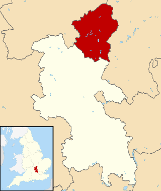
Buckinghamshire is a ceremonial county in South East England and one of the home counties. It is bordered by Northamptonshire to the north, Bedfordshire to the north-east, Hertfordshire to the east, Greater London to the south-east, Berkshire to the south, and Oxfordshire to the west. The largest settlement is the city of Milton Keynes, and the county town is Aylesbury.

Bedfordshire is a ceremonial county in the East of England. It is bordered by Northamptonshire to the north, Cambridgeshire to the north-east, Hertfordshire to the south and the south-east, and Buckinghamshire to the west. The largest settlement is Luton (225,262), and Bedford is the county town.

Milton Keynes is a city in Buckinghamshire, England, about 50 miles (80 km) north-west of London. At the 2021 Census, the population of its urban area was 264,349. The River Great Ouse forms the northern boundary of the urban area; a tributary, the River Ouzel, meanders through its linear parks and balancing lakes. Approximately 25% of the urban area is parkland or woodland and includes two Sites of Special Scientific Interest (SSSIs).
The City of Milton Keynes is a unitary authority area with both borough and city status, in Buckinghamshire. It is the northernmost district of the South East England Region. The borough abuts Bedfordshire, Northamptonshire and the remainder of Buckinghamshire.
Woughton is a civil parish in south central Milton Keynes, Buckinghamshire, England. The parish council uses the term Community Council.

Broughton is a historic village, modern district and civil parish in Milton Keynes, Buckinghamshire, England, approximately 3 miles (4.8 km) east of Central Milton Keynes. It is governed by Broughton and Milton Keynes Joint Parish Council, shared with the neighbouring Milton Keynes parish. Broughton district was developed during the 2000s and 2010s largely to the south and east of the historic village.

Dagnall is a village in the parish of Edlesborough, in Buckinghamshire, England.

Great Linford is a historic village, district and wider civil parish in the north of Milton Keynes, England, between Wolverton and Newport Pagnell, and roughly 2 miles (3.2 km) north of Central Milton Keynes.

Walton was historically a hamlet and now a district and civil parish in Milton Keynes, Buckinghamshire, England. For local government purposes, it is part of the Danesborough and Walton electoral ward.

Whipsnade Tree Cathedral is a 9.5-acre (3.8 ha) garden in the village of Whipsnade in Bedfordshire, England. It is planted in the approximate form of a cathedral, with grass avenues for nave, chancel, transepts, chapels and cloisters and "walls" of different species of trees.

Campbell Park is the name of the central park for Milton Keynes (England) and an electoral ward of the civil parish of Central Milton Keynes..

The Central Milton Keynes shopping area is a regional shopping centre located in Milton Keynes, Buckinghamshire, England which is about 50 miles (80 km) north-west of London. It comprises two adjacent shopping centres, thecentre:mk which opened in 1979, and Midsummer Place opened in 2000. The centre:mk is anchored by John Lewis and Marks & Spencer. The complex is the 14th largest shopping centre in the UK, with the size of 120,773 sq metres.

This history of Milton Keynes details its development from the earliest human settlements, through the plans for a 'new city' for 250,000 people in northern Southeast England, its subsequent urban design and development, to the present day. Milton Keynes, founded in 1967, is the largest settlement and only city in Buckinghamshire. At the 2021 census, the population of its urban area was estimated to have exceeded 256,000.

Whipsnade is a small village and civil parish in Bedfordshire, England. It lies on the eastward tail spurs of the Chiltern Hills, about 2+1⁄2 miles (4.0 km) south-south-west of Dunstable on the top of the Dunstable Downs, which drop away steeply to the south of the village.

Two Mile Ash is a district of north-west Milton Keynes in Buckinghamshire, England, two miles south of Stony Stratford, just off Watling Street. The district was named after the Two Mile Ash toll gate on Watling Street. It is one of the larger districts, but a large part of its area is taken up by Abbey Hill, an 18-hole golf course. Consequently, many of the streets here are named after famous golf courses. The district was one of the first to be built in the (mainly) private housing period of the development of Milton Keynes. It is in Abbey Hill civil parish.

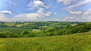
Dunstable and Whipsnade Downs is a 73.4-hectare (181-acre) Site of Special Scientific Interest in Dunstable in Bedfordshire. It was notified in 1987 under Section 28 of the Wildlife and Countryside Act 1981, and the local planning authority is Central Bedfordshire Council. It is in the Chilterns Area of Outstanding Natural Beauty, and part of it is owned by the National Trust.

Howe Park Wood is a 21.4-hectare (53-acre) Site of Special Scientific Interest in Tattenhoe, a district of Milton Keynes in Buckinghamshire. It is owned by Milton Keynes City Council and managed by Milton Keynes Parks Trust.

Milton Keynes Dons Women, usually abbreviated to MK Dons Women, are a women's association football club in Milton Keynes, Buckinghamshire, England. Founded in 2009, the club is affiliated with Milton Keynes Dons. They are currently members of the third tier FA Women's National League South.
Campbell Park is a civil parish in Milton Keynes, Buckinghamshire, England. The parish is bounded by Childs Way (H6) to the north, the River Ouzel to the east, the A5 to the west, and Chaffron Way to the south. The parish includes the § Fishermead, § Newlands, § Oldbrook, § Springfield, § Winterhill, Willen and The Woolstones grid-squares. The parish was originally known as Woolstone-cum-Willen, and was formed on 1 April 1934 as a merger of Great Woolstone, Little Woolstone and Willen. The parish was part of Newport Pagnell Rural District until the latter became part of the Borough of Milton Keynes in 1974. The parish was redefined in 2012, when the districts of Campbell Park (sic), Newlands and Willen were reallocated to other parishes. Despite the loss of its eponymous district, the Parish Council continues to use its name. As of December 2022, the parish council is consulting on changing its name.

