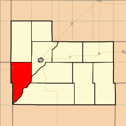
Trenton Township | |
---|---|
Township | |
Location in Edwards County | |
Coordinates: 37°49′33″N099°30′55″W / 37.82583°N 99.51528°W Coordinates: 37°49′33″N099°30′55″W / 37.82583°N 99.51528°W | |
Country | United States |
State | Kansas |
County | Edwards |
Area | |
• Total | 52.56 sq mi (136.13 km2) |
• Land | 52.56 sq mi (136.13 km2) |
• Water | 0 sq mi (0 km2) 0% |
Elevation | 2,231 ft (680 m) |
Population (2000) | |
• Total | 306 |
• Density | 5.8/sq mi (2.2/km2) |
GNIS feature ID | 0473541 |
Trenton Township is a township in Edwards County, Kansas, USA. As of the 2000 census, its population was 306.
A civil township is a widely used unit of local government in the United States that is subordinate to a county. The term town is used in New England, New York, and Wisconsin to refer to the equivalent of the civil township in these states. Specific responsibilities and the degree of autonomy vary based on each state. Civil townships are distinct from survey townships, but in states that have both, the boundaries often coincide and may completely geographically subdivide a county. The U.S. Census Bureau classifies civil townships as minor civil divisions. Currently, there are 20 states with civil townships.
Edwards County is a county located in the U.S. states of Kansas. As of the 2010 census, the county population was 3,037, Its county seat and most populous city is Kinsley. The county was founded in 1874 and named for W. C. Edwards, of Hutchinson, a pioneer settler, who played an active role in its organization.
Kansas is a U.S. state in the Midwestern United States. Its capital is Topeka and its largest city is Wichita, with its most populated county being Johnson County. Kansas is bordered by Nebraska on the north; Missouri on the east; Oklahoma on the south; and Colorado on the west. Kansas is named after the Kansa Native American tribe, which inhabited the area. The tribe's name is often said to mean "people of the (south) wind" although this was probably not the term's original meaning. For thousands of years, what is now Kansas was home to numerous and diverse Native American tribes. Tribes in the eastern part of the state generally lived in villages along the river valleys. Tribes in the western part of the state were semi-nomadic and hunted large herds of bison.
Trenton Township covers an area of 52.56 square miles (136.1 km2) and contains one incorporated settlement, Offerle.
Offerle is a city in Edwards County, Kansas, United States. As of the 2010 census, the city population was 199.
Trenton is the capital city of the U.S. state of New Jersey and the county seat of Mercer County. it briefly served as the capital of the United States in 1784. The city's metropolitan area is grouped with the New York metropolitan area by the United States Census Bureau, but it directly borders the Philadelphia metropolitan area and is part of the Philadelphia Combined Statistical Area and the Federal Communications Commission's Philadelphia Designated Market Area. As of the 2010 United States Census, Trenton had a population of 84,913, making it the state's tenth most populous municipality. The Census Bureau estimated that the city's population was 84,034 in 2014.
Mercer County is a county located in the U.S. state of New Jersey. Its county seat is Trenton, the state capital. The county constitutes the Trenton-Ewing, NJ Metropolitan Statistical Area and is considered part of the New York Metropolitan Area by the United States Census Bureau, but also directly borders the Philadelphia metropolitan area and is included within the Federal Communications Commission's Philadelphia Designated Market Area and the greater Philadelphia-Reading-Camden Combined Statistical Area. As of the 2017 Census estimate, the county's population was 374,733, making it the state's 12th-most populous county, an increase of 2.2% from the 2010 United States Census, when its population was enumerated at 366,513, in turn an increase of 15,752 (4.5%) from the 350,761 enumerated in the 2000 Census, retaining its position as the 12th-most populous county in the state.
Ewing Township is a township in Mercer County, New Jersey, United States. The township is within the New York metropolitan area as defined by the United States Census Bureau. It also directly borders the Philadelphia metropolitan area and is part of the Federal Communications Commission's Philadelphia Designated Market Area. As of the 2010 United States Census, the township's population was 35,790, reflecting an increase of 83 (+0.2%) from the 35,707 counted in the 2000 Census, which had increased by 1,522 (+4.5%) from the 34,185 counted in the 1990 Census.
Hamilton Township is a township in Mercer County, New Jersey, United States. The township is within the New York metropolitan area as defined by the United States Census Bureau, but directly borders the Philadelphia metropolitan area and is part of the Federal Communications Commission's Philadelphia Designated Market Area. As of the 2010 United States Census, the township had a total population of 88,464, reflecting an increase of 1,355 (+1.6%) from the 87,109 counted in the 2000 Census, which had in turn increased by 556 (+0.6%) from the 86,553 counted in the 1990 Census. The township was the state's 9th-largest municipality, after having been ranked 10th in 2000. The township is located immediately east of the city of Trenton, the state's capital.
The Trenton Bath House is a pivotal, influential design by the architect Louis Kahn, with the help of his associate, renowned architect Anne Tyng, at 999 Lower Ferry Road, Ewing Township, Mercer County, New Jersey, United States. It was listed in the National Register of Historic Places in 1984.
East Trenton is a neighborhood located within the city of Trenton in Mercer County, New Jersey, United States. It borders Hamilton Township and is home to a sizable African-American community, besides having small pockets of Latinos and Italians.
West Trenton is a section of Ewing Township in Mercer County, New Jersey, United States. It is a suburban area located adjacent to the northwestern portion of the city of Trenton, from which it derives its name. Located at the intersection of Bear Tavern Road/Grand Avenue and West Upper Ferry Road, it is one of the oldest settlements in Ewing Township.
Eddington is a census-designated place located in Bucks County, Pennsylvania. The community was part of Cornwells Heights-Eddington, which was split into two separate CDPs. As of the 2010 census, the population was 1,906. The community is served by the Eddington station along SEPTA Regional Rail's Trenton Line.
Trenton Township is one of the eighteen townships of Delaware County, Ohio, United States. As of the 2010 United States Census the population was 2,190.
Sugar Creek Township is one of fifteen townships in Clinton County, Illinois, USA. As of the 2010 census, its population was 6,184 and it contained 2,506 housing units. The township's name changed from Trenton Township on June 1, 1874.
Belle Mead station is a train station along the CSX Trenton Subdivision and former New Jersey Transit West Trenton Line in the Belle Mead section of Montgomery Township, in Somerset County, New Jersey, United States. The current station was built by the Reading Railroad in 1913. This replaced the older station which was built in the late 19th century. The current Belle Mead station was closed in 1981 and is still standing. New Jersey Transit may reopen the station as part of the proposed revival of the West Trenton Line. This station was expected to have the second largest ridership on the branch with 290 daily passengers. If the station were to be reopened, two small station buildings would be renovated. Commuter parking would possibly be located on the eastside of the right-of-way with access from Route 206 with 300 parking spaces. The intersection of Township Line Road and Route 206 would be improved along with replacement of the adjacent Route 206 bridge over the railroad.
Trenton Corners is an unincorporated community in Persifer Township, Knox County, Illinois. Trenton Corners is just west of the Spoon River at the intersection of U.S. Highway 150 and Knox County Highway 15. There was formerly an early settlers' town called Trenton. In 1888, the Santa Fe Railway located north of the town. The businesses and the population of the town moved closer to the railroad into the new town of Dahinda and Trenton ceased to be a place of importance. Several small businesses were still located in Trenton Corners until recently but none remain today. The Persifer Township hall and maintenance facility and the Trenton Cemetery are located near Trenton Corners.
Prospect Heights is a neighborhood located within Ewing Township in Mercer County, New Jersey, United States. It is a residential neighborhood primarily consisting of detached, single-family homes built in the 1920s through the 1970s.
Slackwood is an unincorporated community located within Lawrence Township in Mercer County, New Jersey, United States. The area is named for the owners of the land that was subdivided into the neighborhood today, Joseph Slack and William Wood. The neighborhood was first developed in 1890 as the first suburban development in the reconfigured Lawrence Township. Its location between Princeton Pike and Brunswick Pike allowed for an easy walk to nearby Trenton factories. Today, most of the homes in Slackwood are still small bungalows with some businesses along Princeton and Brunswick Pikes. The neighborhood is bounded by the two highways on the northwest and southeast, Slackwood Park and forest on the southwest, and Shabakunk Creek and Park on the northeast.
Prospect Park is a neighborhood located within Ewing Township in Mercer County, New Jersey, United States.
Trenton Gardens is an unincorporated community located within Hamilton Township in Mercer County, New Jersey, United States.
Weber Park is a neighborhood located within Ewing Township in Mercer County, New Jersey, United States. It is a residential neighborhood consisting of a mixture of detached, single-family homes and semi-attached, half-duplexes built in the 1920s through the 1950s. It is adjacent to the Hillcrest section of Trenton.
Duck Island is an unincorporated community located along the border of Hamilton Township and the city of Trenton in Mercer County, New Jersey, United States. The community takes its name from Duck Island, which extends southeastward from the community. The city of Trenton provides public docks for fishing in Duck Island.
Top Road is a neighborhood located within the city of Trenton in Mercer County, New Jersey, United States. Much of Top Road was once part of Lawrence Township and then was added to the now-defunct Millham Township before being annexed by Trenton in 1888.
The John Abbott II House was built ca. 1730 in what is now Hamilton Township, Mercer County, New Jersey. During the American Revolution, Samuel Tucker, the state treasurer, fleeing the British advance on Trenton, removed the money in his care to the home of John Abbott II. The location of the funds was betrayed by Mrs. Mary Pointing, who led a 500-strong detachment of British troops to the house. In ransacking the home, the soldiers discovered Tucker's trunk with his personal effects and £1500 in unsigned paper money. However, the specie money was hidden by the family in the bottom of tubs in the cellar, covered with broken dishes and household utensils. The tubs escaped close inspection and the money was kept from British hands. The house is currently home to the Hamilton Township Historical Society and is open to the public.
This article about a location in Edwards County, Kansas is a stub. You can help Wikipedia by expanding it. |