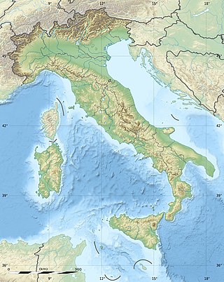
The geography of Italy includes the description of all the physical geographical elements of Italy. Italy, whose territory largely coincides with the homonymous geographical region, is located in southern Europe and comprises the long, boot-shaped Italian Peninsula crossed by the Apennines, the southern side of Alps, the large plain of the Po Valley and some islands including Sicily and Sardinia. Italy is part of the Northern Hemisphere. Two of the Pelagie Islands are located on the African continent.

Don Camillo and Peppone are the fictional protagonists of a series of works by the Italian writer and journalist Giovannino Guareschi set in what Guareschi refers to as the "small world" of rural Italy after World War II. Most of the Don Camillo stories came out in the weekly magazine Candido, founded by Guareschi with Giovanni Mosca. These "Little World" stories amounted to 347 in total and were put together and published in eight books, only the first three of which were published when Guareschi was still alive.

Giovannino Oliviero Giuseppe Guareschi was an Italian journalist, cartoonist, and humorist whose best known creation is the priest Don Camillo.
The Aosta Valley is a mountainous autonomous region in northwestern Italy. It is bordered by Auvergne-Rhône-Alpes, France, to the west; by Valais, Switzerland, to the north; and by Piedmont, Italy, to the south and east. The regional capital is Aosta.

The province of Parma is a province in the Emilia-Romagna region of Italy. Its largest town and capital is the city of Parma.

The province of Belluno is a province in the Veneto region of Italy. Its capital is the city of Belluno.

Tarvisio is a comune (municipality) in the Regional Decentralization Entity of Udine, in the autonomous Friuli-Venezia Giulia region of Italy.

Livigno is a town, comune and a special-administered territory in the province of Sondrio, in the region of Lombardy, Italy, located in the Italian Alps, near the Swiss border.

The Ortler Alps are a mountain range of the Southern Limestone Alps mountain group in the Central Eastern Alps, in Italy and Switzerland.

Sestriere is a ski resort in Piedmont, Italy, a comune (municipality) of the Metropolitan City of Turin. It is situated in Val Susa, 17 km (11 mi) from the French border. Its name derives from Latin: ad petram sistrariam, that is at sixty Roman miles from Turin.

Bormio is a town and comune with a population of about 4,100 located in the Province of Sondrio, Lombardy region of the Alps in northern Italy.
Pontey is a town and comune in the Aosta Valley region of north-western Italy.

Ovada is a comune (municipality) of 11,484 inhabitants in the Province of Alessandria in the northern Italian region Piedmont, located about 90 kilometres (56 mi) southeast of Turin and about 30 kilometres (19 mi) south of Alessandria.

Ne is a comune (municipality) in the Metropolitan City of Genoa in the Italian region Liguria, located in the Val Graveglia about 40 kilometres (25 mi) east of Genoa. It is formed by several distinct burghs, or frazioni.

Brescello is a comune (municipality) in the Province of Reggio Emilia in the Italian region Emilia-Romagna, located about 80 kilometres (50 mi) northwest of Bologna and about 25 kilometres (16 mi) northwest of Reggio Emilia. As of 31 December 2016, it had a population of 5,621.

Foscagno Pass is a high mountain pass in the Alps in the province of Sondrio, northern Italy.

Juf is a village in the municipality of Avers in the canton of Grisons, Switzerland. At 2,126 metres (6,975 ft) above sea level, it is historically the highest village with permanent residents in Western Europe, as well as one of its coldest localities.

The climate of Italy is highly diverse. In most of the inland northern and central regions, the climate ranges from humid subtropical to humid continental and oceanic. The climate of the Po valley geographical region is mostly humid subtropical, with cool winters and hot summers. The coastal areas of Liguria, Tuscany and most of the South experience a Mediterranean climate according to the Köppen climate classification.

Val Poschiavo is a valley in the southern, Italian-speaking part of the Swiss canton of the Grisons. The main town is Poschiavo.
