Trestles

Last updated
The namesake railroad tracks Metrolink Trestles Beach S.jpg
The namesake railroad tracks

Trestles is a collection of surfing spots between northern San Onofre State Beach in San Diego County and southern San Clemente in Orange County in California. [1] Trestles consists of, from north to south, Upper Trestles (Uppers), Lower Trestles (Lowers), and Middle Trestles (Middles). North of Upper Trestles is the surf spot called Cottons. South of Middles is the surf spot called The Church. [2] It is named after Trestles Bridge, a wooden trestle bridge that surfers must walk under to reach the beach, replaced in 2012 by a concrete viaduct. [3] [4]

Contents

Lower Trestles consistently has the best waves of the group.[ citation needed ] For many years there was an WSL World Tour surfing competition held at Lowers every year, as well as the NSSA Nationals. Uppers is less consistent, but it has the potential to be a good wave with a long ride. North of Uppers is Cotton's Point, the location of former President Richard Nixon's home, La Casa Pacifica , aka "The Western White House", and the associated surfing spot of Cottons.

Access and amenities

Trestles has two major access points:

  1. Visitors can park and walk down an asphalt trail to Trestles from the trailhead at Cristianitos Road, near where Cristianitos crosses over the San Diego Freeway. Visitors can expect to see surf graffiti on the sidewalk, with such phrases as "no kooks", "surf hard", "you're going the wrong way", and "duckbutter".[ citation needed ] There is a pay parking lot near the Carl's Jr. restaurant on Coast Highway at Cristianitos, along with some public parking on streets near the restaurant. There is no fee to walk, skateboard, or bike into Trestles by means of this trail. Most visitors enter Trestles by this trail.
  2. Visitors can park at San Onofre State Beach by exiting the San Diego Freeway at Basilone Road, then heading west from the freeway exit to the entrance to the portion of San Onofre State Beach named Surf Beach. The hike northwest to Trestles from Surf Beach at San Onofre State Beach is considerably longer than the hike southwest from the Cristianitos Road bridge and the San Diego Freeway. There is a fee to drive into the State Park at Surf Beach.

Plant and animal life

A California brown pelican at Trestles park. Brown Pelican Trestles Park.jpg
A California brown pelican at Trestles park.

Trestles park is home to a variety of plant and animal life. The most common plant is the coastal sage scrub, which is native to the coast of California and thrives in the area's Mediterranean climate. Trestles park is also home to quite a lot of animal life, including California brown pelicans. These animals used to be endangered species, but the populations recovered so well that the species was removed from the endangered species list in 2009. During times of heavy rains, there is usually a river delta flowing into the ocean where there are often tadpoles.

One plant which grows right out of the sand is the beach evening primrose. Each plants creates a large mat of roots and foliage which is an extremely important aspect of the ecosystem as other plants are able to grow from the stable surface this plants provides. The primrose can be identified by its bright yellow, four petaled flowers which open in the morning, and turn reddish as evening progresses. The primrose has unique medical benefits as well. These flowers aid in the treatment of sore throat and eye diseases. [5]

Seasonal stream

During periods of strong rain, Trestles has a stream that runs through its center and empties into the ocean. [6] Usually, the stream flows during the winter and spring, the seasons with the most rain in Southern California. The stream does not contain much marine life as it dries up without a steady water source. The stream creates a small pool which contains mainly tadpoles. When the stream dries up above ground, an underground water flow still exits into the ocean, just not through a river delta.

Trestles has experienced problems with littering. Many visitors leave trash in the dried stream bed. When the stream flows, it brings the waste into the ocean and onto the beach. Trestles has numerous signs reminding visitors to dispose of waste properly.

Toll road controversy

The California Transportation Corridor Agency (TCA) has sought to construct a 16-mile long six-lanes wide toll highway (graded for eight lanes) through San Onofre State Beach/Park and a habitat reserve in Orange County, joining the San Diego Freeway at Trestles. [7]

The Toll Road, which is one of several routes that could be constructed to extend California State Route 241, is favored by several business groups and public officials from Orange County as a way to ease future traffic congestion. [8] The particular Toll Road route through San Onofre is opposed by more than two dozen members of California's congressional delegation in Washington, D.C., [9] thirty-eight California legislators [10] including former California United States Senator Barbara Boxer, [9] Surfrider Foundation, Defenders of Wildlife, [11] The Sierra Club, The Natural Resources Defense Council, [12] the California State Parks Foundation, the California State Park and Recreation Commission [13] the Native American United Coalition to Protect Panhe, The City Project, the Save San Onofre Coalition, [12] [14] and Save Trestles, [15] among others. Opposition is based upon the damage to the environment that would result from construction and operation of the Toll Road, the loss of park camping and recreational areas, the loss/damage to a site sacred to Native Americans, and studies that show that traffic congestion would actually increase on the San Diego Freeway if the toll road is built through San Onofre Beach. [16] A survey of Orange County voters revealed that while 52% favored a connection in some capacity, 66% opposed the proposed route that would take the Toll Road through San Onofre State Park. [17]

On February 6, 2008, the California Coastal Commission denied a Coastal Permit for the route of the proposed 241 Toll Road that would have cut through San Onofre and the Reserve, saying that of the eight possible routes considered, the one sought by the TCA was the most environmentally damaging. [7] Had a permit been granted, it would have been the first toll road to run through a California state park. [18] On December 18, 2008, The Department of Commerce announced that it would uphold the California Coastal Commission's ruling that found the TCA's proposed extension of the 241 Toll Road inconsistent with the California Coastal Act. [19] The Department of Commerce noted in a release that at least one reasonable alternative to the project existed, and that the project was not necessary in the interest of national security. [20] On May 22, 2013, environmentalists filed a new lawsuit to stop the building of the Toll Road in segments, a tactic they say is an illegitimate end-run around by the TCA after the Toll Road was defeated in 2008. [21]

Panhe is the site of an ancient Acjachemen village [22] in the San Mateo campground area of San Onofre State Beach, straddling the San Diego-Orange county border off Cristianitos Road near Trestles. [23] [24] [25] It remains a sacred, ceremonial, cultural, and burial site for the Acjachemen people. Many Acjachemen people [26] trace their lineage back to Panhe. It is the site of the first baptism in California, and in 1769, the first close contact between Spanish explorers, Catholic missionaries, and the Acjachemen people. The Acjachemen people built the mission at San Juan Capistrano. The advocacy group Save Panhe and San Onofre State Beach state that not only is Panhe one of the most historically significant sacred sites of the Acjachemen people, [27] but that Panhe is also important to all Californians and Americans. [28]

Related Research Articles

San Clemente, California City in California, United States

San Clemente is a coastal city in Orange County, California, United States. The population was 63,522 in at the 2010 census. Located on the California Coast, midway between Los Angeles and San Diego, the southernmost city of Orange County is known for its ocean, hill, and mountain views, a pleasant climate and its Spanish colonial-style architecture. San Clemente's city slogan is "Spanish Village by the Sea". The official city flower is the bougainvillea, and the official city tree is the coral. San Clemente is also the southernmost city in the Los Angeles metropolitan area.

Marine Corps Base Camp Pendleton Large coastal property in San Diego County held by the United States Marine Corps

Marine Corps Base Camp Pendleton is the major West Coast base of the United States Marine Corps and is one of the largest Marine Corps bases in the US. It is on the Southern California coast, in San Diego County, and bordered by Oceanside to the south, San Clemente, and Orange County to the north, Riverside County to the northeast, and Fallbrook to the east.

California State Route 91 Highway in California

State Route 91 (SR 91) is a major east–west state highway in the U.S. state of California that serves several regions of the Greater Los Angeles urban area. A freeway throughout its entire length, it officially runs from Vermont Avenue in Gardena, just west of the junction with the Harbor Freeway, east to Riverside at the junction with the Pomona and Moreno Valley freeways.

California State Route 133 Highway in California

State Route 133 is a state highway in the U.S. state of California, serving as an urban route in Orange County. It connects SR 1 in Laguna Beach through the San Joaquin Hills with several freeways in Irvine, ending at the SR 241, a toll road in the latter city. It is built as an expressway from SR 73 to Laguna Canyon Road, and past this, SR 133 is a freeway to I-5, and a tollway to SR 241 near the Santa Ana Mountains.

FasTrak Toll company

FasTrak is the electronic toll collection (ETC) system used in the state of California in the United States. The system is used statewide on all of the toll roads, toll bridges, and high-occupancy toll lanes along the California Freeway and Expressway System.

El Toro Y Interchange in California

The El Toro "Y" is a freeway interchange in southern Orange County, California where the Santa Ana Freeway, Interstate 5 (I-5), and the San Diego Freeway merge. South of the El Toro Y, the highway is named the "San Diego Freeway" with the highway designation "I-5." Located in south Orange County where the cities of Lake Forest, Laguna Hills, and Irvine converge, the interchange was named after the nearby city and the now-closed Marine Corps Air Station El Toro, located northeast of the interchange.

California State Route 73 Highway and toll road in Orange County, California

State Route 73 is a state highway in the U.S. state of California, running from the junction with Interstate 5 in San Juan Capistrano north through the San Joaquin Hills to its junction with Interstate 405 in Costa Mesa. The entirety of the route is located in Orange County. From its southern terminus, the first 12 miles (19 km) of the highway are a toll road, which opened in November 1996. This segment of SR 73 is operated by the San Joaquin Hills Transportation Corridor Agency named the San Joaquin Hills Transportation Corridor. The last 3 miles (4.8 km) of the 15-mile (24 km) highway, which opened in 1978, are part of the Corona del Mar Freeway. SR 73's alignment follows an approximately parallel path between the Pacific Coast Highway and the San Diego Freeway. For the three-mile freeway segment, there are no HOV lanes currently, but the medians have been designed with sufficient clearance for their construction should the need arise in the future.

California State Route 241 Highway in California

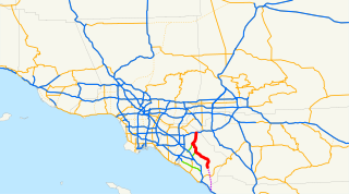
State Route 241 is a state highway in the U.S. state of California that is a toll road for its entire length within Orange County in the Greater Los Angeles urban area. Its southern half from near Las Flores to near Irvine is the Foothill Transportation Corridor, while its northern half to the State Route 91 at the Anaheim–Yorba Linda line is part of the Eastern Transportation Corridor. State Route 241 connects with the other two highways of the Eastern Transportation Corridor, State Route 133 and State Route 261.

San Onofre State Beach

San Onofre State Beach is a 3,000-acre (1,214 ha) state park in San Diego County, California. The beach is 3 miles (5 km) south of San Clemente on Interstate 5 at Basilone Road. The state park is leased to the state of California by the United States Marine Corps. Governor Ronald Reagan established San Onofre State Beach in 1971. With over 2.5 million visitors per year, it is one of the five most-visited state parks in California, hosting swimmers, campers, kayakers, birders, fishermen, bicyclists, sunbathers, surfers, and the sacred Native American site of Panhe.

Wildcoast

Wildcoast is an international non-profit environmental organization that conserve coastal and marine ecosystem and wildlife.

Interstate 5 (I-5) is a major north–south route of the Interstate Highway System in the United States, stretching from the Mexican border at the San Ysidro crossing to the Canadian border near Blaine, Washington. From San Ysidro, the segment of I-5 in California runs north across the length of the state, and crosses into Oregon south of the Medford-Ashland metropolitan area. It is the more important and most-used of the two major north–south routes on the Pacific Coast, the other being U.S. Route 101 (US 101), which is primarily coastal. I-5 is known colloquially as "the 5" to Southern California residents and "5" to Northern California residents due to varieties in California English. The highway connects to the Mexican Federal Highway 1 (Fed. 1) in the south.

Mark Massara is an American surfer, attorney, and environmental conservationist. He first gained a reputation in the surfing and environmental communities when he won a $5.6 million Clean Water Act violation, the second largest ever collected. Since that case, he has assisted nonprofit organizations, including Surfrider Foundation and Sierra Club, government agencies, and private sector enterprises in several high-profile coastal and ocean protection, restoration, education and development campaigns that highlight and achieve coastal conservation and amenities for wildlife and future generations.

Aliso Creek (Orange County) River in the United States of America

Aliso Creek is a 19.8-mile (31.9 km)-long, mostly urban stream in south Orange County, California. Originating in the Cleveland National Forest in the Santa Ana Mountains, it flows generally southwest and empties into the Pacific Ocean at Laguna Beach. The creek's watershed drains 34.9 square miles (90 km2), and it is joined by seven main tributaries. As of 2018, the watershed had a population of 144,000 divided among seven incorporated cities.

Laguna Canyon Canyon in Orange County, California, US

Laguna Canyon is a canyon that cuts through the San Joaquin Hills in southern Orange County, California, in the United States, directly south of the city of Irvine. The canyon runs from northeast to southwest, and is drained on the north side by tributaries of San Diego Creek and on the south by Laguna Canyon Creek. It is deeper and more rugged on the southwestern end near Laguna Beach.

Sulphur Creek (California) Creek in California, United States

Sulphur Creek is a 4.5-mile (7.2 km) tributary of Aliso Creek in Orange County in the U.S. state of California. The creek drains about 6 square miles (16 km2) of residential communities and parks in the southern San Joaquin Hills.

San Mateo Creek (Southern California)

San Mateo Creek is a stream in Southern California in the United States, whose watershed mostly straddles the border of Orange and San Diego Counties. It is about 22 miles (35 km) long, flowing in a generally southwesterly direction. Draining a broad valley bounded by the Santa Ana Mountains and Santa Margarita Mountains, San Mateo Creek is notable for being one of the last unchannelized streams in Southern California.

Trestles Bridge

Trestles Bridge, more formally known as Railroad Bridge 207.6 or the San Mateo Creek Bridge, is a low railroad viaduct on the coast of Southern California, in northern San Diego County near its border with Orange County. The bridge lies within San Onofre State Beach and gave its nickname to the famed Trestles surfing site at that beach.

Panhe, was one of the largest Acjachemen villages, that is over 8,000 years old and a current sacred, ceremonial, cultural, and burial site for the Acjachemen people. The site of Panhe, is now within San Onofre State Beach, San Diego County, California, located at the confluence of San Mateo Creek and Cristianitos Canyon, approximately 3.7 miles (6.0 km) upstream from the Pacific Ocean. The Acjachemen's fished in San Mateo Creek's extensive freshwater marshes, and practiced a hunter-gatherer lifestyle. The village of Panhe is estimated to have had a population of 300 or so before the first Spanish explorers came to the area, and is still a sacred site for the Native Americans.

Surfin U.S.A. Single by the Beach Boys

"Surfin' U.S.A." is a song by the American rock band the Beach Boys credited to Chuck Berry and Brian Wilson. It is a rewritten version of Berry's "Sweet Little Sixteen" set to new lyrics penned by Wilson and an uncredited Mike Love. The song was released as a single on March 4, 1963, backed with "Shut Down". It was then placed as the opening track on their album of the same name.

References

  1. San Onofre State Beach - State of California
  2. "Archived copy". Archived from the original on 2009-07-26. Retrieved 2010-01-26.CS1 maint: archived copy as title (link) Middles gets its name because it was a middle area between Trestles (both Uppers and Lowers breaks) and The Church (sometimes just called "Church"). Refs: State of CA: "Archived copy" (PDF). Archived from the original (PDF) on 2011-06-22. Retrieved 2010-02-17.CS1 maint: archived copy as title (link); County of Orange:; Books: Surfer Magazine's Guide to Southern California Surf Spots (2006) ISBN   978-0-8118-5000-1, The Encyclopedia of Surfing by Matt Warshaw (2005) ISBN   978-0-15-100579-6; Magazines: SportsIllustrated , Global Surf News "Archived copy". Archived from the original on 2011-07-20. Retrieved 2010-02-17.CS1 maint: archived copy as title (link) "Archived copy". Archived from the original on 2010-02-22. Retrieved 2010-02-17.CS1 maint: archived copy as title (link), San Diego Coastal Life , "Surf Transworld", Surfer’s Village ; Newspapers: Orange County Register , Global Surf News "Archived copy". Archived from the original on 2011-07-20. Retrieved 2010-02-17.CS1 maint: archived copy as title (link), Surfer Today ; Organizations: World Surfing Association , Surfrider "Archived copy" (PDF). Archived from the original (PDF) on 2010-06-15. Retrieved 2010-02-17.CS1 maint: archived copy as title (link) "Archived copy". Archived from the original on 2010-02-20. Retrieved 2010-02-17.CS1 maint: archived copy as title (link), SaveTrestles ; Surf forecasting sites: Surfline , Surfforecast.com
  3. Rojas, Rick (May 14, 2012), "New Trestles bridge opens: Much of the original, 1941 wooden structure near the famed San Diego County surf spot has been replaced – under budget and six months ahead of schedule – with reinforced concrete", Los Angeles Times : AA3.
  4. Swegles, Fred (May 14, 2012), "Gleaming new bridge adorns iconic Trestles surf spot", Orange County Register .
  5. "Practical and Medical Uses of the Beach Evening Primrose" . Retrieved 13 November 2012.
  6. "California Rainy Season Chart" . Retrieved 13 November 2012.
  7. 1 2 Weikel, Dan; Reyes, David (2008-02-07). "Panel rejects beach toll road". Los Angeles Times . pp. A-1. Retrieved 2008-08-07.
  8. Rodgers, Terry (2008-07-21). "Hearing on toll road will be rescheduled". San Diego Union-Tribune . Retrieved 2008-08-07.
  9. 1 2 Reyes, David (2008-04-17). "Toll road foes apply pressure". Los Angeles Times . pp. B-3. Retrieved 2008-08-07.
  10. Volzke, Jonathan (2008-08-07). "More Politicians Weighing on the Toll Road". San Clemente Times. Retrieved 2008-08-07.
  11. Rosenblatt, Susannah (2008-08-15). "Environmental groups sue federal agencies over San Onofre toll road". Los Angeles Times . Retrieved 2008-08-15.
  12. 1 2 Rodgers, Terry (2008-08-14). "Suit filed on toll road report". San Diego Union-Tribune . Retrieved 2008-08-14.
  13. Brokaw, Nick (2008-08-14). "Personnel Profile: Bobby Shriver". Capital Weekly. Retrieved 2008-08-14.
  14. City Wire (2008-08-14). "Environmentalists Sue Over Toll Road Report". Channel 10 News - San Diego. Retrieved 2008-08-14.
  15. "Save Trestles".
  16. [OCTA's 2006 Long Range Transportation Plan, PEIR, at pp. 5-5 and 5-11, July 26, 2006.]
  17. Conaughton, Gig (2007-10-05). "Parks panel survey says voters oppose toll road". North County Times . Retrieved 2008-08-07.
  18. Rodgers, Terry (2008-02-07). "Toll road proposal voted down". San Diego Union-Tribune . Retrieved 2008-08-07.
  19. Rosenblatt, Susannah (2008-12-19). "O.C. toll road hits dead end in D.C." Los Angeles Times. Retrieved 2009-03-11.
  20. "Decision and Findings" (PDF). US Secretary of Commerce. 2008-12-18. Retrieved 2009-03-11.
  21. http://www.lompocrecord.com/news/state-and-regional/environmentalists-sue-over-oc-toll-road-extension/article_00c842f9-c8ba-57fe-a272-d2faa11948c1.html [ bare URL ]
  22. Panhe is 10,000 years old. http://www.onlinewithbob.com/protect_panhe.html
  23. http://articles.latimes.com/2007/aug/20/local/me-toll20 [ bare URL ]
  24. http://sanofoundation.org/site/events/95-surfet-saltwater-sweetheart-board-fest-february-14-2009 [ bare URL ]
  25. "[LAAMN] UNITED COALITION TO PROTECT PANHE Art Auction Call to Artists; Exhibition Call for Entries: WOMEN ARTISTS ON IMMIGRATION". www.mail-archive.com.
  26. Called Juaneño by the Spanish. http://www.cityprojectca.org/ourwork/SavePanheSaveSanOnofre.html
  27. "California Native American Heritage Commission". nahc.ca.gov.
  28. "Save Panhe".

Coordinates: 33°23′06″N117°35′42″W / 33.385°N 117.595°W / 33.385; -117.595