
Calderdale is a metropolitan borough of West Yorkshire, England, which had a population of 211,439. It takes its name from the River Calder, and dale, a word for valley. The name Calderdale usually refers to the borough through which the upper river flows, while the actual landform is known as the Calder Valley. Several small valleys contain tributaries of the River Calder. The main towns of the borough are Brighouse, Elland, Halifax, Hebden Bridge, Sowerby Bridge and Todmorden.

The A58 is a major road in Northern England running between Prescot, Merseyside and Wetherby, West Yorkshire.

Sheepscar is an inner city district of Leeds in West Yorkshire England, lying to the north east of Leeds city centre. The district is in the City of Leeds Metropolitan Council. It is overlooked by the tower blocks of Little London and Lovell Park to the west, and gives way to Meanwood in the north-west, Chapeltown in the north-east and Burmantofts in the east.

The Leeds Inner Ring Road is part-motorway and part-A roads in Leeds, West Yorkshire, England, which forms a ring road around the city centre. It has six different road numbers that are all sections of longer roads. Clockwise, the roads are the A58(M), a motorway section of the A58 road; the A64(M), part of the A64 road; the A61 between York Road and the M621; the M621 between junctions 4 and 2; and the A643 between the M621 and A58. The motorway section is in total is 2.5 miles (4.0 km) long and is subject to a 40 miles per hour (64 km/h) speed limit throughout.

Cragg Vale is a village in Calderdale, West Yorkshire, England, located south of Mytholmroyd on the B6138 road which joins the A58 and the A646. The village is part of Luddendenfoot Ward of Calderdale Council.

Cottingham is a large village and civil parish in the East Riding of Yorkshire, England. It lies 4 miles (6 km) north-west of the centre of Kingston upon Hull, and 6 miles (10 km) south-east of Beverley on the eastern edge of the Yorkshire Wolds. It forms part of Hull's Urban Area. It has two main shopping streets, Hallgate and King Street, which cross each other near the Church of Saint Mary the Virgin, and a market square called Market Green. Cottingham had a population of 17,164 residents in 2011, making it larger by area and population than many towns. As a result, it is one of the villages claiming to be the largest village in England.

Barnsdale, or Barnsdale Forest, is an area of South and West Yorkshire, England. The area falls within the modern-day districts of Doncaster and Wakefield. Barnsdale was historically part of the West Riding of Yorkshire. Barnsdale lies in the immediate vicinity north and north-west of Doncaster, and which was formerly forested and a place of royal hunts, and also renowned as a haunt of the outlaw Robin Hood in early ballads.

The River Ryburn is a river in West Yorkshire, England. It flows through the villages of Rishworth, Ripponden and Triangle before flowing into the River Calder at Sowerby Bridge.
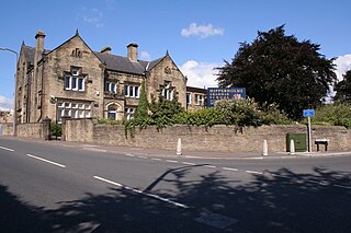
Hipperholme is a village in West Yorkshire, England, located between the towns of Halifax and Brighouse in the Hipperholme and Lightcliffe ward of the Metropolitan Borough of Calderdale. The population of this ward at the 2011 Census was 11,308.

Collingham is a village and civil parish 2 miles (3 km) south-west of Wetherby in West Yorkshire, England. It is in the City of Leeds metropolitan borough. The population of the civil parish as of the 2011 census was 2,991.

Sowerby was a county constituency centred on the village of Sowerby in Calderdale, West Yorkshire. It returned one Member of Parliament (MP) to the House of Commons of the Parliament of the United Kingdom.
The A660 is a major road in the Leeds and Bradford districts of West Yorkshire, England that runs from Leeds city centre to Burley-in-Wharfedale where it meets the A65. The A660 is approximately 10 miles (16 km) long, and crosses the watershed from Airedale to lower Wharfedale. For most of its length the road is in the metropolitan district of the City of Leeds; the last 0.4 miles (0.6 km) is in City of Bradford district.
The Leeds Outer Ring Road is a main road that runs around most of the perimeter of the city of Leeds, West Yorkshire, England. The ring road is approximately 29 miles and consists of single and dual carriageways. The road is not a loop and so is not a true ring road, although it is designated as such.

The Leeds Country Way is a circular long-distance footpath of 62 miles (99 km) around Leeds, West Yorkshire, England. It is never more than 7 miles (11 km) from City Square, Leeds, but is mainly rural with extensive views in the outlying areas of the Leeds metropolitan district. It follows public Rights of Way including footpaths, bridleways and minor lanes, with a few short sections along roads.
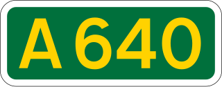
The A640 is a road in England which runs between Rochdale in Greater Manchester and Huddersfield in West Yorkshire.
Arnold Williams was a British businessman and Liberal politician.

Orchard Park Estate is an area or housing estate situated on the north-western side of Kingston upon Hull, England.
National Cycle Network (NCN) Route 66 is a Sustrans National Route that runs from Kingston upon Hull to Manchester via Beverley, York and Leeds.

The River Calder is a river in West Yorkshire, in Northern England.

Friendly is a settlement near Sowerby Bridge in Calderdale, West Yorkshire, England, lying on the A646 road in the valley of the River Calder. It was described in Bartholomew's 1887 Gazetteer of the British Isles as a village 3 miles west of Halifax.
