
A defensive wall is a fortification usually used to protect a city, town or other settlement from potential aggressors. The walls can range from simple palisades or earthworks to extensive military fortifications with towers, bastions and gates for access to the city. From ancient to modern times, they were used to enclose settlements. Generally, these are referred to as city walls or town walls, although there were also walls, such as the Great Wall of China, Walls of Benin, Hadrian's Wall, Anastasian Wall, and the Atlantic Wall, which extended far beyond the borders of a city and were used to enclose regions or mark territorial boundaries. In mountainous terrain, defensive walls such as letzis were used in combination with castles to seal valleys from potential attack. Beyond their defensive utility, many walls also had important symbolic functions – representing the status and independence of the communities they embraced.

A moat is a deep, broad ditch, either dry or filled with water, that is dug and surrounds a castle, fortification, building or town, historically to provide it with a preliminary line of defence. In some places moats evolved into more extensive water defences, including natural or artificial lakes, dams and sluices. In older fortifications, such as hillforts, they are usually referred to simply as ditches, although the function is similar. In later periods, moats or water defences may be largely ornamental. They could also act as a sewer.

A fortification is a military construction or building designed for the defense of territories in warfare, and is also used to establish rule in a region during peacetime. The term is derived from Latin fortis ("strong") and facere.

The fortifications of Portsmouth are extensive due to its strategic position on the English Channel and role as home to the Royal Navy. For this reason, Portsmouth was, by the 19th century, one of the most fortified cities in the world. The fortifications have evolved over the centuries in response to changes in tactics and technology and the area defended has increased. While the first defences focused on Portsmouth harbour, in step with the fortifications of Gosport, later defensive structures protected the whole of Portsea Island and an increasing distance inland. At the same time, the fortifications of Portsmouth and Gosport became part of the wider fortifications of the Solent. Old Portsmouth, on the southwest corner of Portsea Island, has been walled for much of its history.

Kastellet located in Copenhagen, Denmark, is one of the best preserved fortresses in Northern Europe. It is constructed in the form of a pentagon with bastions at its corners. Kastellet was continuous with the ring of bastioned ramparts which used to encircle Copenhagen but of which only the ramparts of Christianshavn remain today.

Neuf-Brisach is a fortified town and commune of the department of Haut-Rhin in the French region of Alsace. The fortified town was intended to guard the border between France and the Holy Roman Empire and, subsequently, the German states. It was built after the Treaty of Ryswick in 1697 that resulted in France losing the town of Breisach, on the opposite bank of the Rhine. The town's name means New Breisach.

The existence of the earliest forts in India have been substantiated by documentation and excavation. In the medieval times, the architecture of the forts had both Hindu and Muslim influence. The forts constructed by the British initially opted for simple designs. The existing castles are continually modified and many of them are privately owned.

The fortifications of Xi'an, also known as Xi'an City Wall, in Xi'an, represent one of the oldest, largest and best preserved Chinese city walls. It was built under the rule of the Hongwu Emperor Zhu Yuanzhang as a military defense system. It exhibits the "complete features of the rampart architecture of feudal society". It has been refurbished many times since it was built in the 14th century, thrice at intervals of about 200 years in the later half of the 1500s and 1700s, and in recent years in 1983. The wall encloses an area of about 14 square kilometres (5.4 sq mi).

The fortifications of Copenhagen is the broad name for the rings of fortifications surrounding the city of Copenhagen. They can be classified historically as follows:
Zürich was an independent (reichsfrei) city or city-state from 1218 to 1798. The town was fortified with a city wall from the 13th to the 17th century, and with more elaborate ramparts constructed in the 17th to 18th century and mostly demolished in the 1830s to 1870s.

The fortifications of Kotor are an integrated historical fortification system that protected the medieval town of Kotor containing ramparts, towers, citadels, gates, bastions, forts, cisterns, a castle, and ancillary buildings and structures. They incorporate military architecture mainly of Venice, but also a few of Illyria, Byzantium, and Austria. Together with the old town and its natural surroundings the fortifications were inscribed in the list of World Heritage Sites in 1979 labelled Natural and Culturo-Historical Region of Kotor and represent the only such site of cultural significance in Montenegro.
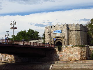
43.32599°N 21.89508°E
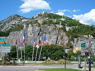
The Bastille is the name of a fortress culminating at 476 m (1,561ft) above sea level, located at the south end of the Chartreuse mountain range and overlooking the city of Grenoble, France. The Bastille, which also gives its name to the hill, is the main tourist site of the Grenoble area with 600 000 visitors per year.

The fortifications of Copenhagen underwent a comprehensive modernization and expansion in the 17th century. The project was commenced and was largely the masterplan of Christian IV in the early 17th century but was continued and completed by his successors. The new fortifications relied on the existing, medieval fortifications of the city but the fortified area was extended and a defensive ring around the city completed particularly with new edifices facing the sea. The ring fortification consisted of four bastioned ramparts and an annexed citadel as well as various outworks.

Gifhorn Castle is a castle in Gifhorn, Germany, built between 1525 and 1581 in the Weser Renaissance style. The castle was fortified until 1790 with moats, ramparts and bastions and was never captured. In the 16th century it was the Residenz of the Duchy of Gifhorn under Duke Francis of Brunswick-Lüneburg for just 10 years.
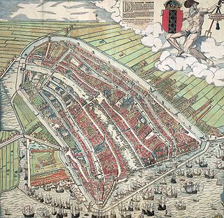
The walls of Amsterdam were built in the Middle Ages to protect the city against attack. The Medieval walls were replaced with a series of bastions in the 17th century. In the 19th century, the walls were torn down and replaced with the Defence Line of Amsterdam, a fortification line which encircled Amsterdam at a distance from the city.

A Zwinger is an open kill zone area between two defensive walls that is used for defensive purposes. Zwingers were built in the post-classical and early modern periods to improve the defence of castles and town walls. The term is German and usually left untranslated. However, it is sometimes rendered as "outer courtyard" presumably referring to the subsequent role of a Zwinger as a castle's defences became redundant and it was converted into a palace or schloss, however, this belies its original purpose as a form of killing ground for the defence. The word is linked with zwingen, "to force", perhaps because the Zwinger forced an enemy to negotiate it before assaulting the main defensive line. Essenwein states that the "main purpose of this feature was so that the besieging force could not reach the actual castle wall very easily with battering rams or belfries, but had to stop at the lower, outer wall; also that two ranks of archers, behind and above one another, could fire upon the approaching enemy"

In fortification architecture, a rampart is a length of bank or wall forming part of the defensive boundary of a castle, hillfort, settlement or other fortified site. It is usually broad-topped and made of excavated earth or masonry or a combination of the two.

Bastejkalns Park is a spacious park on the eastern edge of the old town of Latvian capital Riga.

Dytynets Park (Chernihiv) is the most ancient area of Chernihiv is Dytynets. It is a hill on the bank of the Desna River, where a defense complex is situated. Walking along the alleys of the park, you can feel the spirit of ancient times, marvel at the panorama of the Boldyna Hora, see the numerous churches and cathedrals, and observe the whole city.At the viewing point, there are 12 cast-iron bastion cannons from the seventeenth century, which are the calling card of the city. By the way, Dytynets is a perfect spot to have a lunch in one of the traditional cuisine restaurants.


