Related Research Articles

Elmira Corning Regional Airport is in Chemung County, New York, seven miles northwest of Elmira and eight miles east of Corning. It is in the town of Big Flats but its mailing address is Horseheads, New York. The airport was formerly Elmira Regional Airport.
Jacksonville Executive at Craig Airport, formerly known as Craig Municipal Airport, is a public airport located eight miles (13 km) east of the central business district of Jacksonville, in Duval County, Florida, United States. It is owned by the Jacksonville Aviation Authority.

Dubuque Regional Airport is a regional airport located eight miles south of Dubuque, in Dubuque County, Iowa. On U.S. Highway 61, the airport is owned by the city of Dubuque and is operated as a department of the city government. The city council appoints people for four-year terms to the Airport Commission board, which oversees the airport. For day-to-day operations, the Commission hires an airport manager. DBQ is used for general aviation and sees one airline. A charter service is run by Sun Country Airlines. The airport offers maintenance and refueling services, including service for jets.

Pryor Field Regional Airport is a public airport located three miles (5 km) northeast of the central business district of Decatur and south of Athens, in Limestone County, Alabama, United States. It is owned by Decatur/Athens Airport Authority.
Hoopa Airport is a public airport located on Airport Road next to the Trinity River, one mile (1.6 km) southeast of Hoopa, serving Humboldt County, California, United States. It is mostly used for general aviation.

Denton Enterprise Airport, also known as Denton Airport and previously Denton Municipal Airport, is a city-owned, public-use airport located three nautical miles (6 km) west of the central business district of Denton, a city in Denton County, Texas, United States.
Weaverville Airport, also known as Lonnie Pool Field, is a public airport located one mile (1.6 km) northeast of Weaverville, serving Trinity County, California, United States. This general aviation airport covers 65 acres (26 ha) and has one runway.
The Chicago O'Hare UFO sighting occurred on November 7, 2006, around 4:15 p.m. when 12 United Airlines employees and a few witnesses outside O'Hare International Airport reported a sudden UFO sighting. The Federal Aviation Administration refused to investigate the matter because this UFO was not seen on radar, instead calling it a "weather phenomenon".
Delaware County Regional Airport is in Delaware County, Indiana three miles northwest of Muncie. Owned by the Delaware County Airport Authority, it was formerly Delaware County Airport and Johnson Field. The National Plan of Integrated Airport Systems for 2011–2015 categorized it as a general aviation facility.
Fort Walton Beach Airport is a public-use airport located two miles east of the central business district of Navarre, in Santa Rosa County, Florida, United States. It is privately owned by John S. Williams.
Beaver County Airport or is a county-owned public airport three miles northwest of Beaver Falls, in Beaver County, Pennsylvania.
Hendricks County Airport, also known as Gordon Graham Field, is a public airport at 2749 Gordon Graham Blvd. in Danville, a town in Hendricks County, Indiana, United States. Owned by the Indianapolis Airport Authority, it is located 13 miles (21 km) west of the central business district of Indianapolis and serves as a reliever airport for Indianapolis International Airport. The airport is also two miles (3 km) southeast from the center of Danville.
Bob Sikes Airport, named for Robert L. F. Sikes, is a public-use airport located 3 miles (4.8 km) northeast of the central business district of the city of Crestview in Okaloosa County, Florida, United States. The airport is publicly owned and supports a mix of general aviation and aerospace corporations performing modification work on military aircraft. The airport sees frequent military training use by aircraft based at Eglin AFB, Duke Field, Hurlburt Field, NAS Pensacola, NAS Whiting Field and Fort Rucker.

Donaldson Field Airport is a public airport six miles (10 km) south of the central business district of Greenville, a city in Greenville County, South Carolina, United States. It is located at the Donaldson Center Industrial Air Park and is owned by the City and County of Greenville.
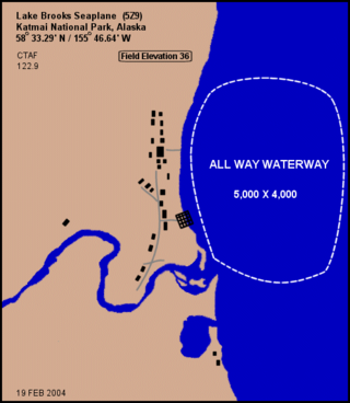
Lake Brooks Seaplane Base is a public-use seaplane base located near Brooks Camp in Katmai National Park, in the Lake and Peninsula Borough of the U.S. state of Alaska. It is owned by the U.S. Department of the Interior.
Peter Prince Field is a public-use airport located 3 miles (4.8 km) east of the central business district of the city of Milton in Santa Rosa County, Florida, United States. The airport is publicly owned.
DeFuniak Springs Airport is a public-use airport located two nautical miles (3.7 km) west of the central business district of the city of DeFuniak Springs in Walton County, Florida, United States. The airport is publicly owned and operated by the City of DeFuniak Springs and serves the general aviation transportation needs of the City and Walton County. In addition to private and recreational flying, the airport also supports business and corporate aviation. The airport is situated on 343 acres of land located approximately 2.5 miles west of the City's Central Business District.
North Whale Seaplane Base is a state owned, public use seaplane base located in North Whale Pass, a community in the Prince of Wales-Hyder Census Area of the U.S. state of Alaska. It is included in the National Plan of Integrated Airport Systems for 2011–2015, which categorized it as a general aviation facility.

Copper Center Airport, also known as Copper Center 2 Airport, is a state-owned public-use airport located one nautical mile south of the central business district of Copper Center, in the Copper River Census Area of the U.S. state of Alaska, United States.

Trenton–Mercer Airport is a county-owned, joint civil–military, public airport located four miles northwest of Trenton in the West Trenton section of Ewing Township, Mercer County, New Jersey. Formerly known as Mercer County Airport, the airport serves one scheduled airline plus general and corporate aviation. The U.S. Department of Transportation reports that approximately 201,000 passengers departed and 200,000 arrived at the airport in the 12 months ending October 2021, for a total of 401,000 passengers.