Interstate 45 (I-45) is a major Interstate Highway located entirely within the U.S. state of Texas. While most Interstate routes which have numbers ending in "5" are cross-country north–south routes, I-45 is comparatively short, with the entire route located in Texas. Additionally, it has the shortest length of all the interstates that end in a "5". It connects the cities of Dallas and Houston, continuing southeast from Houston to Galveston over the Galveston Causeway to the Gulf of Mexico.

Interstate 355 (I-355), also known as the Veterans Memorial Tollway, is an Interstate Highway and tollway in the western and southwest suburbs of Chicago in the U.S. state of Illinois. Like most other toll roads in the northeastern portion of the state, I-355 is maintained by the Illinois State Toll Highway Authority (ISTHA). I-355 runs from I-80 in New Lenox north to I-290 in Itasca, a distance of 32.5 miles (52.3 km). With the exception of a four-mile (6.4 km) expansion in 2009, from U.S. Route 34 to 75th Street, the highway is six lanes wide for its entire length.

State Highway 121 is a state highway angling from southwest to northeast through north central Texas. It runs from Cleburne, Texas at US 67 to SH 78 in Bonham, Texas, just north of a junction with US 82.

State Highway 360 is a 28-mile (45 km) north–south state highway in the Dallas–Fort Worth metroplex in the U.S. state of Texas. It runs north from an at-grade intersection with US 287 in Mansfield, near the Ellis-Johnson county line to a partial interchange with SH 121 in Grapevine, near Dallas/Fort Worth International Airport. The highway serves as a local north–south route running through the center of the metroplex, linking together the southern and northern suburbs to the core. Between US 287 and Camp Wisdom Road/Sublett Road, SH 360 follows a pair of frontage roads along a four-lane tollway known as the 360 Tollway, a tollway operated by the NTTA. Between Camp Wisdom Road/Sublett Road and SH 121, SH 360 follows a toll-free freeway maintained by TxDOT.

Interstate 88 (I-88) is an Interstate Highway in the US state of Illinois that runs from an interchange with I-80 near Silvis and Moline to an interchange with I-290 and I-294 in Hillside, near Chicago. I-88 is 140.60 miles (226.27 km) long. This route is not contiguous with I-88 in New York. Since 2010, most of I-88 has been part of the Chicago–Kansas City Expressway. The highway also runs through the cities of Aurora, Naperville, DeKalb, and Dixon. East of Rock Falls, the route is a part of the Illinois Tollway system.
The President George Bush Turnpike (PGBT) is a 52-mile (84 km) toll road running through the northern, northeastern and western suburbs, forming a partial loop around Dallas, Texas, United States. It is named for the late George H. W. Bush, the 41st president of the United States. At its west end near Belt Line Road in Irving, State Highway 161 continues southwest to Interstate 20 (I-20) in Grand Prairie. The discontinuous free frontage roads along the turnpike from I-35E in Carrollton east to its end at I-30 in Garland are assigned the State Highway 190 designation. SH 190 signage appears only along the Rowlett, Garland, Richardson, Plano, and Carrollton sections of the frontage road with the undersign "frontage road only". At intersections with city streets, only the Bush Turnpike signs are displayed, not the SH 190 signage. Prior to the construction of the main lanes as a tollway, SH 190 was used as the name of the planned main lanes too. Similarly, the part west of I-35E was planned as part of SH 161. Bush Turnpike is signed as a north–south road from I-20 to I-35E, an east–west road from I-35E to the Merritt Main Lane Gantry and as a north–south road from the Merritt Main Lane Gantry to I-30, as Bush Turnpike makes a nearly 90-degree curve in both places.

The Dallas North Tollway is a 30.2-mile (49 km) controlled-access toll road operated by the North Texas Tollway Authority (NTTA), which runs from Interstate 35E near downtown Dallas, Texas (USA), to U.S. Highway 380, in Frisco, Texas.

Interstate 635 (I-635) is a 37-mile-long (60 km) partial loop around Dallas, Texas, in the United States between I-20 in Balch Springs and State Highway 121 (SH 121) at the north entrance of the Dallas/Fort Worth International Airport (DFW Airport) in Grapevine. It intersects I-35E at exits 27B and 27C, but does not connect with I-35W. I-635 and a part of I-20 are collectively designated as the Lyndon B. Johnson Freeway; known locally as the LBJ Freeway, or simply LBJ. The roadway is named after Lyndon B. Johnson, the former US Senator from Texas, 37th Vice President, and the 36th President of the United States. Where I-635 ends at I-20, I-20 continues the LBJ Freeway designation heading west. Since the portion of I-20 between State Highway Spur 408 (Spur 408) to I-635 retains the same names as I-635, the two highways are considered 3/4 of the beltway around Dallas. Together with Spur 408, a portion of State Highway Loop 12, and a portion of I-35E, the Stemmons Freeway, I-635 and I-20 complete the beltway.

The Westpark Tollway, also Fort Bend Westpark Tollway, is a limited-access toll road in Texas, serving western Houston and Harris County, and northeastern Fort Bend County. Construction on the facility began in 2001 and portions of the road were opened to traffic in May 2004. Construction of the roadway was completed in August 2005. The Westpark Tollway begins on Westpark Drive just past the South Rice Avenue intersection in the Uptown District of Houston and runs approximately 22 miles (35 km) west to Farm to Market Road 1093 just past Farm to Market Road 723 in Fulshear, Texas. It runs roughly parallel and to the south of Westheimer Road in Harris County and concurrently with FM 1093 in Fort Bend County.
The Addison Airport Toll Tunnel, also known as the Addison Airport Tunnel and the Addison Toll Tunnel, is part of the North Texas Tollway Authority (NTTA) system and extends Keller Springs Road under the Addison Airport property.
The North Texas Tollway Authority (NTTA) is an organization that maintains and operates toll roads, bridges, and tunnels in the North Texas area. Functioning as a political subdivision of the State of Texas under Chapter 366 of the Transportation Code, the NTTA is empowered to acquire, construct, maintain, repair and operate turnpike projects; to raise capital for construction projects through the issuance of turnpike revenue bonds; and to collect tolls to operate, maintain and pay debt service on those projects.

The Fort Bend Parkway Toll Road is the Fort Bend County (i.e.,southern) portion of a continuous toll road connecting Sienna in eastern Fort Bend County to US 90A in southwestern Harris County. It is administered by the Fort Bend County Toll Road Authority (FBCTRA). The Harris County Toll Road Authority (HCTRA) administers the Harris County segment of the road — from just south of Beltway 8 at the county line to US 90A — and uses its purple pentagonal shield labeled as Fort Bend Toll Road. It is proposed to reach a northern terminus at the southwestern corner of Interstate 610 in the future, and SH 99 at its southern terminus.
The Harris County Toll Road Authority maintains and operates a 103-mile (165.8 km) toll road system in the Greater Houston area of Texas, United States. Its headquarters are located in Houston's Fairbanks/Northwest Crossing neighborhood.

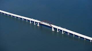
The Lewisville Lake Toll Bridge (LLTB) is a 1.7 mile (2.7 km) tied arch bridge crossing Lewisville Lake in Denton County, Texas, USA. The North Texas Tollway Authority (NTTA) worked cooperatively with Denton County to plan and design a toll bridge across the northwestern arm of Lewisville Lake. The four-lane toll bridge connects Swisher Road in Lake Dallas to Eldorado Parkway in Little Elm, Texas. The Lewisville Lake Corridor is approximately 13.8 miles long and is divided into eight sections constructed by Denton County, NTTA, TxDOT, Little Elm, and Frisco, Texas. The bridge is the second longest bridge in the North Texas area, behind the Texas State Highway 66 bridge over Lake Ray Hubbard between Rowlett and Rockwall approximately 30 miles to the southeast.
The Chisholm Trail Parkway is a toll road operated by the North Texas Tollway Authority (NTTA) in Tarrant and Johnson counties connecting the central business district of the city of Fort Worth at Interstate 30 to US 67 in Cleburne.
The Trinity River Project is a public works project undertaken in the 2000s in the city of Dallas, Texas, United States. Its goal is to redevelop the Trinity River. The project aims to turn the river's path into a collection of sports fields, trails, nature centers, and recreational opportunities. At 10,000 acres (4,000 ha), it is one of the larger urban parks in the United States.

Interstate 90 (I-90) in the US state of Illinois runs roughly northwest-to-southeast through the northern part of the state. From the Wisconsin state line at South Beloit, it heads south to Rockford before heading east-southeast to the Indiana state line at Chicago. I-90 traverses 124 miles (200 km) through a variety of settings, from farmland west of the Fox River Valley through the medium-density suburbs west of O'Hare International Airport, through Downtown Chicago, and through the heart of the industrial southeast side of Chicago before entering Indiana.

A barrier toll system is a method of collecting tolls on highways using toll barriers at regularly spaced intervals on the toll road's mainline. Motorists are typically charged a flat-rate toll, unlike toll roads with a ticket system where the toll rate is determined by the distance traveled or number of exits passed. Some highways use coin-drop machines on toll plazas. For toll roads whose ramps have no toll plazas, it is possible to exit the toll road before the mainline toll plaza, use local streets to bypass it, then re-enter the highway via an interchange on the other side of the toll plaza. Thus it is possible to drive on some barrier toll roads while paying less or not paying at all; this is the basis of the "open" descriptor.
There are approximately 25 current toll roads in the state of Texas. Toll roads are more common in Texas than in many other U.S. states, since the relatively low revenues from the state's gasoline tax limits highway planners' means to fund the construction and operation of highways.
The Sam Rayburn Tollway is a tollway operated by the North Texas Tollway Authority that runs from Grapevine to McKinney. Its frontage roads are signed State Highway 121.


