
Iwanai is a district located in Shiribeshi Subprefecture, Hokkaidō, Japan.
Sorlada is a town and municipality located in the province and autonomous community of Navarre, northern Spain.

Đurđin is a village located in the Subotica municipality, in the North Bačka District of Serbia. It is situated in the autonomous province of Vojvodina. The village is ethnically mixed and its population numbering 1,746 people.
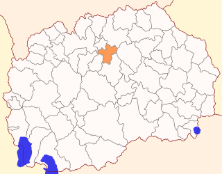
The Municipality of Petrovec is a municipality in northern Republic of North Macedonia, near the capital Skopje. Petrovec is also the name of the village where the municipal seat is found. It is located in the Skopje Statistical Region.
The Stadio comunale Enzo Blasone is a multi-use stadium in Foligno, Italy. It is currently used mostly for football matches and is the home stadium of Foligno Calcio. It holds 4.650.

Mirosławice is a village in the administrative district of Gmina Sobótka, within Wrocław County, Lower Silesian Voivodeship, in south-western Poland. Prior to 1945 it was in Germany.
Jhando Khel is a town and union council of Bannu District in Khyber Pakhtunkhwa province of Pakistan. It is located 32°57'12N 70°42'53E and has an elevation of 307 metres.

Zalesie is a village in the administrative district of Gmina Cekcyn, within Tuchola County, Kuyavian-Pomeranian Voivodeship, in north-central Poland. It lies approximately 5 kilometres (3 mi) north of Cekcyn, 11 km (7 mi) east of Tuchola, and 56 km (35 mi) north of Bydgoszcz.
Elżbiecin is a village in the administrative district of Gmina Grajewo, within Grajewo County, Podlaskie Voivodeship, in north-eastern Poland.
Stare Sypnie is a village in the administrative district of Gmina Grodzisk, within Siemiatycze County, Podlaskie Voivodeship, in north-eastern Poland.
Józefów is a village in the administrative district of Gmina Przedbórz, within Radomsko County, Łódź Voivodeship, in central Poland. It lies approximately 9 kilometres (6 mi) south-east of Przedbórz, 36 km (22 mi) east of Radomsko, and 92 km (57 mi) south of the regional capital Łódź.
Krępa is a village in the administrative district of Gmina Gołcza, within Miechów County, Lesser Poland Voivodeship, in southern Poland. It lies approximately 3 kilometres (2 mi) south-east of Gołcza, 7 km (4 mi) south-west of Miechów, and 30 km (19 mi) north of the regional capital Kraków.
Jasień is a village in the administrative district of Gmina Łopuszno, within Kielce County, Świętokrzyskie Voivodeship, in south-central Poland. It lies approximately 2 kilometres (1 mi) west of Łopuszno and 29 km (18 mi) west of the regional capital Kielce.
Strych is a village in the administrative district of Gmina Maciejowice, within Garwolin County, Masovian Voivodeship, in east-central Poland.
Lasek is a village in the administrative district of Gmina Żabia Wola, within Grodzisk Mazowiecki County, Masovian Voivodeship, in east-central Poland.
Obręb is a village in the administrative district of Gmina Góra Kalwaria, within Piaseczno County, Masovian Voivodeship, in east-central Poland. It lies approximately 8 kilometres (5 mi) west of Góra Kalwaria, 15 km (9 mi) south-east of Piaseczno, and 31 km (19 mi) south of Warsaw.

Nadrlje is a village in Central Serbia (Šumadija), in the municipality of Rekovac, lying at 43°48′27″N20°57′12″E, at the elevation of 520 m. According to the 2002 census, the village had 229 citizens.
Malawa, Niger is a village and rural commune in Niger.

Guberevac is a town in the municipality of Leskovac, Serbia. According to the 2002 census, the town has a population of 1875 people.
Suharno is a village in the municipality of Bujanovac, Serbia. According to the 2002 census, the town has a population of 309 people. Of these, 307 were ethnic Albanians, 1 Bosniak, and 1 other.


