Albania is a country in southeastern Europe that lies along the Adriatic and Ionian Seas, with a coastline spanning approximately 476 km (296 mi). Situated on the Balkan Peninsula, it is one of the most mountainous countries in Europe. It is bounded by Montenegro to the northwest, Kosovo to the northeast, North Macedonia to the east and Greece to the southeast and south.

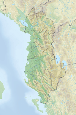
Kukës County is a landlocked county in northeastern Albania, with the capital in Kukës. The county spans 2,374 square kilometres (917 sq mi) and had a total population of 61,998 people as of 2021. The county borders on the counties of Dibër, Lezhë and Shkodër and the countries of Montenegro, Kosovo and North Macedonia. It is divided into three municipalities: Has, Kukës and Tropojë. The municipalities are further subdivided into 290 towns and villages in total.
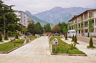
Bajram Curri, formerly known as Kolgecaj until 1952, is a town and administrative unit in the municipality of Tropojë, northeastern Albania, within the historical ethnographic region of the Gjakova Highlands. The town is located in a remote and mountainous region of the Albanian Alps, within the Valbonë Valley, and close to the border with Kosovo. It is named after Bajram Curri, a national hero who fought for ethnic Albanians, first against the Ottoman Empire and later against the Albanian government.
The Šar Mountains or Sharr Mountains is a mountain range in Southeast Europe, extending into several countries from southern Kosovo, to northwestern North Macedonia, to northeastern Albania. The sections in Kosovo, and in North Macedonia are national parks. Rugged and barren, the mountains are among the highest in the Balkans, with 30 peaks higher than 2,500 m (8,202 ft).

Montenegro is a small, mountainous country in Southeast Europe. It borders Croatia, Bosnia and Herzegovina, Serbia, Kosovo, Albania and the Adriatic Sea. While being a small country at 13,812 km2 (5,333 sq mi), it is very diverse regarding the terrain configuration. Montenegro has 50 peaks of over 2,000 m (6,600 ft) in altitude.

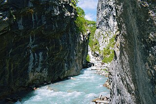
The Drin is a river in Southeastern Europe with two major tributaries – the White Drin and the Black Drin and two distributaries – one discharging into the Adriatic Sea, in the Gulf of Drin and the other into the Buna River. Its catchment area extends across Albania, Kosovo, Serbia, Greece, Montenegro and North Macedonia and is home to more than 1.6 million people. The river and its tributaries form the Gulf of Drin, an ocean basin that encompasses the northern Albanian Adriatic Sea Coast.

Tropojë is a municipality in Kukës County, northeastern Albania, within the historical ethnographic region of the Gjakova Highlands. The municipality consists of the administrative units of Bajram Curri, Bujan, Bytyç, Fierzë, Lekbibaj, Llugaj, Margegaj and Tropojë, that became municipal units. The seat of the municipality is the town Bajram Curri. As of the Institute of Statistics 2023 census, there were 2,560 people residing in the municipal unit Tropojë and 14,189 in the municipality.

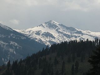
The Accursed Mountains, also known as the Albanian Alps, is a mountain range in coastal Southeast Europe adjacent to the Adriatic Sea. It is the southernmost subrange of the 1,000-kilometre-long (621 mi) Dinaric Alps range (Dinarides), extending from northern Albania to western Kosovo and northeastern Montenegro. Maja Jezercë, standing at 2,694 m (8,839 ft), is the highest point of the Accursed Mountains and of all Dinaric Alps, and the fifth highest peak in Albania. The range includes the mountain Zla Kolata, which, at 2,534 m (8,314 ft), is the tallest mountain in Montenegro. The range also includes the mountain Gjeravica, which, at 2,656 m (8,714 ft), is the second tallest mountain in Kosovo. One of the southernmost glacial masses in Europe was discovered in the Albanian part of the range in 2009.

The White Drin or White Drim is a river in Kosovo and northern Albania, a ca. 140-kilometre (87 mi) long headstream of the Drin.

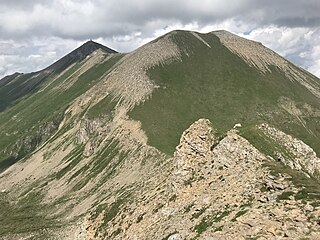
Gjeravica is a mountain peak in Kosovo. It also is the second-highest mountain peak in the Accursed Mountains range and the Dinaric Alps range, after Jezercë. It has an elevation of 2,656 m (8,714 ft) above sea level. Gjeravica is in the western part of Kosovo, in the municipality of Junik.

Kosovo is a landlocked country in Southeastern Europe. The country is strategically positioned in the center of the Balkan Peninsula enclosed by Montenegro to the west, Serbia to the north and east, North Macedonia to the southeast, and Albania to the southwest. It has no direct access to the Mediterranean Sea but its rivers flow into three seas, the Adriatic, Aegean and Black Sea.

Zla Kolata or Kollata e Keqe is one of the highest peaks of the Accursed Mountains, on the border of Albania and Montenegro.

Bogićevica is a mountain area in the Accursed Mountains mountain range. It spreads over Montenegro, Kosovo and Albania. It is about 15 km (9 mi) long and 10 km (6 mi) wide. The mountain area has a number of peaks higher than 2,000 m (6,562 ft) and two higher than 2,500 m (8,202 ft). Marijash and Maja e Ropës are both located in Kosovo. The towns of Deçan in Kosovo and Tropojë in Albania are located near the area.

Gjeravica Lake or Đeravica Lake is a mountain lake in Kosovo located just under the summit of Gjeravica mountain.
Trekufiri, is a mountain located in the Albanian Alps and the Bogićevica range. Perched at 2,366 m (7,762 ft) above sea level, its summit marks the border where Albania, Kosovo, and Montenegro intersect. The height of the three-country point varies, with Albanian maps recording the mountain's height as 2,354 m (7,723 ft) above sea level while official Yugoslavian sources state it as 2,366 m.

Upper Defsko Lake is a mountain lake situated in the Šar Mountains at an elevation of 2,130 m (6,988 ft) above sea level in Kosovo. A small stream originates from Upper Defsko Lake and flows south to join with the Radika river.

Mitrovica District is one of the seven districts of Kosovo. Its administrative center and the largest city is Mitrovica. The district borders on the District of Peja to the south-west, the District of Pristina to the south and east, and the Serbia to the north and northwest.

Rugova is a mountain region located to the north-west of the city of Peja, in Kosovo. According to notes of Rugova it has been inhabited since before the 12th century. In 2013, it was designated a national park by the Parliament of Kosovo.
The Gashi is a 27-kilometre-long (17 mi) river located in Tropojë, northern Albania. It was a nature reserve, spanning an area of 3,000 ha. The nature reserve forms a part of the European Green Belt and has been declared a UNESCO World Heritage Site within the Primeval Beech Forests of the Carpathians and Other Regions of Europe. In 2022, the protected area was amalgamated to form the Alps of Albania National Park.