A subterranean river is a river or watercourse that runs wholly or partly beneath the ground, one where the riverbed does not represent the surface of the Earth. It is distinct from an aquifer, which may flow like a river but is contained within a permeable layer of rock or other unconsolidated materials. A river flowing below ground level in an open gorge is not classed as subterranean.
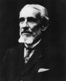
Édouard-Alfred Martel, the 'father of modern speleology', was a world pioneer of cave exploration, study, and documentation. Martel explored thousands of caves in his native France and many other countries, popularised the pursuit of cave exploration, introduced the concept of speleology as a distinct area of scientific study, maintained an extensive archive, and in 1895 founded Société de Spéléologie, the first organisation devoted to cave science in the world.

Saint-Casimir is a municipality of about 1800 people in the Portneuf Regional County Municipality in the province of Quebec, Canada. It is located on the Sainte-Anne River, about 80 kilometres (50 mi) southwest of Quebec City and 50 kilometres (31 mi) northeast of Trois-Rivières.

The Sainte-Anne River, a north shore tributary of Saint Lawrence River, the mouth river is located at Sainte-Anne-de-la-Pérade. This river flows in the province of Quebec, Canada.
Administrative regions
Capitale-Nationale:
Mauricie:

The Jacques-Cartier River is a river in the province of Quebec, Canada. It is 161 km long and its source is Jacques-Cartier Lake in Laurentides Wildlife Reserve, and flows in a predominantly southern direction before ending in the Saint Lawrence River at Donnacona, about 30 km upstream from Quebec City.

Batiscan River has its source in the region of Lac Édouard, in the Laurentians Mountains, the Batiscan River flows over a length of 177 km. It receives water from numerous tributaries, including, in its upper reach, the Rivière aux Éclairs and the Jeannotte river. In its downstream part, it waters Saint-Narcisse and Sainte-Geneviève-de-Batiscan before flowing into the St. Lawrence River at Batiscan.
Rivière Blanche or Blanche River may refer to:

The Noire River flows in the municipality of rivière-à-Pierre, Saint-Alban and Saint-Casimir, in the Portneuf Regional County Municipality, in the administrative region of Capitale-Nationale, in Quebec, in Canada.
The Nedlouc River is a tributary of the Leaf River of northern Quebec, Canada, ultimately flowing into Ungava Bay. Its source is Nedlouc Lake.

The Blanche River (St-Casimir) is a stream flowing in the municipalities of Saint-Ubalde, Saint-Thuribe, Saint-Alban and Saint-Casimir, in the Portneuf Regional County Municipality, in the administrative region from Capitale-Nationale, to Quebec, to Canada.

The Weller River (Stream) is a tributary left bank of the Blanche River (St-Casimir) whose confluence is found east of the municipality of Saint-Ubalde, in the Portneuf Regional County Municipality, in the administrative region of Capitale-Nationale, in the province of Quebec in Canada.

The Niagarette River is a stream flowing in the municipalities of Saint-Ubalde, Saint-Thuribe and Saint-Casimir, in the Portneuf Regional County Municipality, in the administrative region of Capitale-Nationale, in Quebec, in Canada.
The Rivière Jacquot is a tributary of the Sainte-Anne River flowing in the municipalities of Saint-Léonard-de-Portneuf and Sainte-Christine-d'Auvergne, in the MRC Portneuf Regional County Municipality, in the administrative region of Capitale-Nationale, in Quebec, in Canada.

Portneuf Regional Natural Park is a Quebec regional park (Canada) spanning five municipalities in the northwestern part of the Portneuf Regional County Municipality: Saint-Ubalde, Saint-Alban, Saint-Casimir, Portneuf and Rivière-à-Pierre. This park is administered on the basis of a social economy enterprise with the mission of showing visitors around an exceptional territory and contributing to its preservation and enhancement.

The rivière du Moulin is a tributary of the northwest shore of the Saint-Laurent river, descending in the municipality of Deschambault-Grondines, in the Portneuf Regional County Municipality, in the administrative region of Capitale-Nationale, in Quebec, in Canada.

Gouffre Mirolda is a karstic cave located in the Haut-Giffre mountain range, in the commune of Samoëns, Haute-Savoie, France. It is connected to the Lucien Bouclier cave system, and has a depth of −1,661 m (−5,449 ft).

The Bournillon cave is located in the commune of Châtelus in the Isère Department of France, in the Vercors Massif. Its entrance is 105 metres (344 ft) high, and 60 metres (200 ft) wide, and is the largest in Europe. It is one of the main karst springs of Vercors, with a maximum flow rate of 80 cubic metres (2,800 cu ft) per second, which feeds a hydroelectric plant.

The Réseau du Clot d'Aspres is a cave system located mainly under the valley of Clot d'Aspres, which lies within the commune of Villard-de-Lans in the north of the Vercors Massif, in Isère, France. This extensive karst system contains 42 kilometres (26 mi) of passages over a height range of 1,066 meters. The highest point is upstream of the Oréade cave +74 metres (243 ft), and the lowest point is the siphon of the Nuits-Blanches scialet which has been dived to a depth of 34 metres (112 ft).

The Gouffre de la Pierre Saint-Martin, also called Gouffre Lépineux, is the original entrance to a major cave system located in the massif of La Pierre Saint-Martin, in the immediate vicinity of the Franco-Spanish border and the French commune of Arette, in the Pyrénées-Atlantiques in the Nouvelle-Aquitaine region, under which lies part of the cave network.

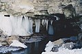
The Gournier Cave is located near Choranche in the Vercors Massif in south-eastern France. The entrance is at an altitude of 572 m (1,877 ft) at the base of a cliff on the Presles plateau. It is one of the exsurgences of the Coulmes massif, and the cave is considered by many speleologists to be the most beautiful underground river in the Alps.