Saint-Casimir, Quebec

Last updated

Saint-Casimir
Saint Casimir 070.jpg
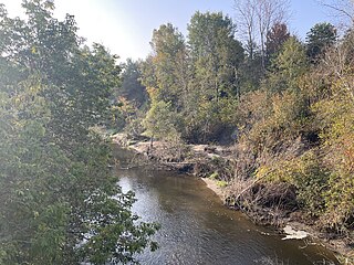
Confluence of the Sainte-Anne and Noire rivers, Park of the statue of the Virgin, tip of Grandbois island [1]
Saint-Casimir Quebec location diagram.png
Location within Portneuf RCM.
Canada Central Quebec location map.png
Red pog.svg
Saint-Casimir
Location in central Quebec.
Coordinates: 46°39′N72°08′W / 46.650°N 72.133°W / 46.650; -72.133 [2]
CountryFlag of Canada (Pantone).svg  Canada
Province Flag of Quebec.svg  Quebec
Region Capitale-Nationale
RCM Portneuf
ConstitutedAugust 21, 2000
Government
[3]
  MayorDominic Tessier Perry
   Federal riding Portneuf—Jacques-Cartier
   Prov. riding Portneuf
Area
  Total68.10 km2 (26.29 sq mi)
  Land66.75 km2 (25.77 sq mi)
Elevation
27.5 m (90.2 ft)
Population
 (2011) [4]
  Total1,500
  Density22.5/km2 (58/sq mi)
  Pop 2006-2011
Decrease2.svg 1.8%
  Dwellings
736
Time zone UTC−5 (EST)
  Summer (DST) UTC−4 (EDT)
Postal code(s)
Area code(s) 418 and 581
HighwaysQc354.svg R-354
Qc363.svg R-363
Website www.saint-casimir.com

Saint-Casimir is a municipality located in Les Chenaux RCM, Mauricie region, Quebec, Canada. [2]

Contents

It is bathed by Sainte-Anne (Les Chenaux), Blanche (Saint-Casimir), Noire (Sainte-Anne River tributary) and Niagarette rivers.

History

Sacre-Coeur-de-Jesus Parish Church, Place de l'Eglise (Church square) Saint-Casimir Church.JPG
Sacré-Cœur-de-Jésus Parish Church, Place de l'Église (Church square)

Saint-Casimir was founded in 1836 by people who came from Ste-Anne-de-la-Pérade following to the east along the Sainte-Anne. Alain Grandbois (1900 – 1975) was born in Saint-Casimir. [2]

In the summer of 1973, a wave on the Niagarette River devastated a small area, where it joins the Sainte-Anne River. A few houses were destroyed by the powerful water wave, due to strong rain, and debris that blocked the small river for a few hours. [6]

On the morning of 22 March 1997, five members of the Order of the Solar Temple died in a mass suicide in Saint-Casimir. A small house exploded into flames, leaving behind five charred bodies for the police to pull from the rubble. Three teenagers, the children of one of the couples who died in the fire, were discovered in a shed behind the house, alive but heavily drugged. [7]

The church, and the town, is named after Saint Casimir, a patron saint of Poland, Lithuania, and youth. [2]

Floods and ice breakups

The Sainte-Anne, Noire and Niagarette rivers cross the heart of Saint-Casimir. The village has a rich history of struggles against the overflowing of these rivers. On the banks, the built heritage bears witness to coexistence with floods and ice breakups.

At the Park of the statue of the Virgin, built in 1972, on the boat-shaped structure at the tip of Grandbois Island, [1] a flood marker bathes in the waters of the rivers combined, these markers remind us of the power of the blows 'water. From memory: When the red line is no longer visible, there is water in the basements! [8]

Geography

Upstream entrance to the cave of the Trou du Diable (Devil's Hole) 19950224 3555 2350 Trou du Diable.jpg
Upstream entrance to the cave of the Trou du Diable (Devil's Hole)

Two provincial numbered roads go through St-Casimir: Route 354 (east-west - from Ste-Anne de la Pérade to St-Raymond) and Route 363 (south-north - from Deschambault to Lac-aux-Sables). Both roads lead to Autoroute 40, the Montreal-Québec City link on the north shore.

Five rivers run in Saint-Casimir: Sainte-Anne, Niagarette, Petite Niagarette, Blanche and Noire.

Saint-Casimir is also the home to a cavern, the "Trou du Diable" ("Devil's Hole"). It is the second-longest cave in Québec, at 980 metres (3,220 ft). It was formed by the former tributary of the Sainte-Anne River, which left behind a stream. Many tourists pass through it every summer. [10] [11]

Demographics

Population trend: [16]

Private dwellings occupied by usual residents: 670 (total dwellings: 736)

Mother tongue:

See also

Related Research Articles

<span class="mw-page-title-main">Deschambault-Grondines</span> Municipality in Quebec, Canada

Deschambault-Grondines is a municipality located in the Portneuf Regional County Municipality (RCM), in the Capitale-Nationale region, Quebec, Canada.

<span class="mw-page-title-main">Mékinac Regional County Municipality</span> Regional county municipality in Quebec, Canada


Mékinac is a regional county municipality (RCM) of 5,607 km2 located in the administrative region of Mauricie, along the Saint-Maurice River, which also crosses the RCM from one end to the other, and the Matawin River, a tributary of the Saint-Maurice. Located in the province of Quebec, Canada.

<span class="mw-page-title-main">Les Chenaux Regional County Municipality</span> Regional county municipality in Quebec, Canada

Les Chenaux is a regional county municipality in central Quebec, Canada, in the Mauricie region. The seat is in Saint-Luc-de-Vincennes. It is located adjacent on the east of Trois-Rivières on the Saint Lawrence River. It has a land area of 872.04 square kilometres (336.70 sq mi) and a population of 17,865 inhabitants in the Canada 2011 Census. Its largest community is the parish of Notre-Dame-du-Mont-Carmel.

<span class="mw-page-title-main">Quebec Route 354</span> Highway in Quebec

Route 354 is an east-west regional road in Quebec, Canada, starting from Route 159 north of Ste-Anne de la Pérade going to St-Raymond. It follows the Rivière Ste-Anne on the south shore most of the time. It is 55 km long, and overlaps Route 363 about 4 km in St-Casimir. Between St-Casimir and Ste-Anne-de-la-Pérade, it is named the "Rapide Nord", where it is the only part it is on the north shore of the river. It becomes rue Tessier Ouest in the village zone. This section was really bad until fall 2005, when it was newly paved on 12 km. Once it crosses the Rivière Ste-Anne, in the village of St-Casimir, it takes the name of rue (street) Notre-Dame.

<span class="mw-page-title-main">Sainte-Anne River (Les Chenaux)</span> River in Quebec, Canada

Sainte-Anne River, Teyaiar River, rivière Sainte-Anne (French), flows from north to south on the north shore in the estuary section of the St. Lawrence River, in Les Chenaux, Portneuf and La Jacques-Cartier RCM, Mauricie and National Capital regions, Quebec, Canada.

<span class="mw-page-title-main">Sainte-Anne-de-la-Pérade</span> Municipality in Quebec, Canada

Sainte-Anne-de-la-Pérade is a municipality, located near the mouth of the Sainte-Anne River, on the north shore of the St. Lawrence River, Les Chenaux RCM, in Mauricie region, Quebec, Canada.

<span class="mw-page-title-main">Saint-Prosper-de-Champlain, Quebec</span> Municipality in Quebec, Canada

Saint-Prosper-de-Champlain is a municipality of 516 people in the Les Chenaux Regional County Municipality, in Quebec, Canada. It is the smallest municipality in terms of population in the regional county.

<span class="mw-page-title-main">Sainte-Christine-d'Auvergne, Quebec</span> Municipality in Quebec, Canada

Sainte-Christine-d'Auvergne (Municipality), formerly Sainte-Catherine, is located along the banks of the Sainte-Anne River, in the Capitale-Nationale region, Portneuf RCM, Quebec, Canada.

<span class="mw-page-title-main">Trou du Diable</span>

The Trou du Diable is a cave situated in St-Casimir municipality, in the province of Quebec, Canada.

<span class="mw-page-title-main">Saint-Ubalde</span> Municipality in Quebec, Canada

Saint-Ubalde is a rural municipality in Portneuf County in the Canadian province of Quebec.

<span class="mw-page-title-main">Sainte-Geneviève-de-Batiscan</span> Parish municipality in Quebec, Canada

Sainte-Geneviève-de-Batiscan is a parish municipality in the Mauricie region of the province of Quebec in Canada. This municipality is part of the Les Chenaux Regional County Municipality in Batiscanie and in the administrative region of Mauricie. It is located along the Batiscan River.

<span class="mw-page-title-main">Saint-Alban, Quebec</span> Place in Quebec, Canada

Saint-Alban (Municipality) is crossed in its southern part by the Sainte-Anne River, in Portneuf RCM, Capitale-Nationale, Quebec, Canada.

The Lordship of Sainte-Anne-de-la-Pérade was located on the north shore of St. Lawrence river, between Trois-Rivières and Quebec City in the province of Quebec, Canada. The southern front of the manor was on the edge of St. Lawrence river. The depth of the lordship was heading north, parallel to the Lordship of Batiscan. The northern boundary of the Lordship of Sainte-Anne-de-la-Perade stopped at the north-western boundary of St. Joseph row, in Sainte-Thècle. In comparison, the lordship of Batiscan spanned 20 "lieues", beyond the Saint-Maurice River. The western boundary of the manor cut the Batiscan river at the rapids of Manitou, between Saint-Adelphe and Saint-Stanislas. The estates of the north shore of St. Lawrence river fell within the stately administrative division of Trois-Rivières.

<span class="mw-page-title-main">Charest River</span> River in Quebec, Canada

The Charest River originates from Charest Lake in the Montauban-les-Mines area, located in the eastern part of Notre-Dame-de-Montauban, within the Mekinac Regional County Municipality, in the administrative region of Mauricie in the province of Quebec, Canada. It flows southward, passing through several regions and receiving water from lakes such as Mine, Perron, Perreault, and End in its upper course.

<span class="mw-page-title-main">Noire River (Sainte-Anne River tributary)</span> River in Quebec, Canada

Noire River, Rivière Noire (French) is one of the main watercourses of the Sainte-Anne River watershed, it measures 62 km in length, its watershed has an area of ​​568 km².

<span class="mw-page-title-main">Blanche River (Saint-Casimir)</span> River in Quebec, Canada

The Blanche River (St-Casimir) is a stream flowing in the municipalities of Saint-Ubalde, Saint-Thuribe, Saint-Alban and Saint-Casimir, in Portneuf RCM, Capitale-Nationale, Quebec, Canada.

<span class="mw-page-title-main">Niagarette River</span> River in Quebec, Canada

The Niagarette River is a stream flowing in the municipalities of Saint-Ubalde, Saint-Thuribe and Saint-Casimir, in the Portneuf Regional County Municipality, in the administrative region of Capitale-Nationale, in Quebec, in Canada.

<span class="mw-page-title-main">Long Lake (Saint-Alban)</span> Lake in Saint-Alban, Quebec, Canada


Long Lake, Lac Long (French), is entirely located in Saint-Alban (Municipality), Portneuf RCM, Capitale-Nationale, Quebec, Canada.

<span class="mw-page-title-main">Clair Lake (Sainte-Christine-d'Auvergne)</span> Lake in Capitale-Nationale, Quebec, Canada

Lake Clair (Sainte-Christine-d'Auvergne), Lac Clair (French) is located in the municipalities of Saint-Alban and Sainte-Christine-d’Auvergne, Portneuf RCM, Capitale-Nationale, Quebec, Canada.

References

  1. 1 2 "Grandbois island, toponymy". Gouvernement of Quebec (in French). Commission de Toponymy Quebec. 18 December 1979. Retrieved 18 November 2024. The origin of this name and, if applicable, its meaning have not yet been determined. The Toponymy Commission invites anyone with information on any of these aspects to contribute.
  2. 1 2 3 4 5 "Saint-Casimir, toponymy". Gouvernement of Quebec (in French). Commission de Toponymy Quebec. 24 August 2000. Retrieved 18 November 2024. The main local attraction is a vast underground cave, colloquially called Trou du Diable, the second largest in Quebec, located on the south bank of the Sainte-Anne, 3 km east of the village. Saint-Casimir remains a dynamic industrial and commercial center.
  3. Ministère des Affaires municipales, des Régions et de l'Occupation du territoire - Répertoire des municipalités: Saint-Casimir
  4. "Saint-Casimir, Quebec (Code 2434078) Census Profile". 2011 census . Government of Canada - Statistics Canada.
  5. "Sacred Heart of Jesus Parish (Portneuf)" (in French). Catholic Church of Quebec. 2024. Retrieved 18 November 2024. 110, place De l'Église Saint-Casimir (QC) G0A 3L0
  6. Genois, Gaétan. "Page of history: the flood in Saint-Casimir, August 10, 1973". Le Courrier de Portneuf (in Canadian French). Retrieved 13 September 2023.
  7. "La fin tragique de la secte de l'Ordre du Temple solaire" [The tragic end of the cult of the Order of the Solar Temple]. Aujourd'hui l'histoire (in Canadian French). Ici Radio-Canada Première . Retrieved 13 September 2023.
  8. Emmanuelle Bouchard-Bastien (2023). "Amphibian spaces, power and memory: the fluctuations of the Sainte-Anne River" (PDF) (in French). Laval University. pp. 22, 247 of 435. The river is the purpose of a complex hydrological dynamic, where water circulates through territories shaped by geology, climate and human activities.
  9. "Grotte le Trou du Diable". Parc naturel régional de Portneuf (in French). Société québécoise de spéléologie. Retrieved 6 September 2023.
  10. Paul Hinse. "Inventory of Portneuvois' built heritage - Saint-Casimir - John William Hopkins" (PDF) (in French). pp. 65 on 248. Retrieved 30 October 2023.
  11. "Saint-Casimir, odonymie" (PDF) (in French). Saint-Casimir. 2019. p. 5. Retrieved 31 October 2023.
  12. "Virtual tour, church of St_Casimir" (in French). Portneuf virtual. Retrieved 30 October 2023.
  13. "Inventory and inspection of structures". Quebec Gouvernement. Ministry of Transport and Sustainable Mobility. Retrieved 27 May 2023.
  14. "Fermeture préventive du pont de la route 354 à Saint-Casimir" (in French). Courrier de Portneuf. 26 April 2023. Retrieved 2 September 2023.
  15. "Inventory and inspection of structures". Quebec Gouvernement. Ministry of Transport and Sustainable Mobility. Retrieved 27 May 2023.
  16. Statistics Canada: 1996, 2001, 2006, 2011 census