Portneuf County is a historic county in Quebec, Canada west of Quebec City on the Saint Lawrence River in Canada.

Saint-Casimir is a municipality located in Portneuf RCM, Capitale-Nationale region, Quebec, Canada.

Route 354 is an east-west regional road in Quebec, Canada, starting from Route 159 north of Ste-Anne de la Pérade going to St-Raymond. It follows the Rivière Ste-Anne on the south shore most of the time. It is 55 km long, and overlaps Route 363 about 4 km in St-Casimir. Between St-Casimir and Ste-Anne-de-la-Pérade, it is named the "Rapide Nord", where it is the only part it is on the north shore of the river. It becomes rue Tessier Ouest in the village zone. This section was really bad until fall 2005, when it was newly paved on 12 km. Once it crosses the Rivière Ste-Anne, in the village of St-Casimir, it takes the name of rue (street) Notre-Dame.

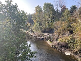
Sainte-Anne River, Teyaiar River, rivière Sainte-Anne (French), flows from north to south on the north shore in the estuary section of the St. Lawrence River, in Les Chenaux, Portneuf and La Jacques-Cartier RCM, Mauricie and National Capital regions, Quebec, Canada.

Sainte-Christine-d'Auvergne, formerly Sainte-Catherine, is located along the banks of the Sainte-Anne River, in the Capitale-Nationale region, Portneuf RCM, Quebec, Canada.

Trou du Diable is a cave situated in Portneuf Regional Natural Park, St-Casimir Municipality, Portneuf RCM, Capital Nationale, Quebec, Canada.
Le Ministère des Transports et de la Mobilité Durable du Québec, known by its short form name Transports Québec or alternatively by the acronym MTQ, is a Quebec government ministry responsible for transport, infrastructure and law in Quebec, Canada.

Saint-Ubalde is a rural municipality in Portneuf County in the Canadian province of Quebec.

Saint-Alban is a municipality located in Portneuf RCM, Capitale-Nationale region, Quebec, Canada.
The Charest River originates from Charest Lake in the Montauban-les-Mines area, located in the eastern part of Notre-Dame-de-Montauban, within the Mekinac Regional County Municipality, in the administrative region of Mauricie in the province of Quebec, Canada. It flows southward, passing through several regions and receiving water from lakes such as Mine, Perron, Perreault, and End in its upper course.

Noire River, Rivière Noire is one of the main watercourses of the Sainte-Anne River watershed, it measures 62 km in length, its watershed has an area of 568 km².

The Weller River (Stream) is a tributary left bank of the Blanche River (St-Casimir) whose confluence is found east of the municipality of Saint-Ubalde, in the Portneuf Regional County Municipality, in the administrative region of Capitale-Nationale, in the province of Quebec in Canada.

The Niagarette River is a stream flowing in the municipalities of Saint-Ubalde, Saint-Thuribe and Saint-Casimir, in the Portneuf Regional County Municipality, in the administrative region of Capitale-Nationale, in Quebec, in Canada.
The Petite rivière Niagarette is a tributary of the Niagarette River, crossing the municipalities of Saint-Thuribe and Saint-Casimir, in the Portneuf Regional County Municipality, in the administrative region of Capitale-Nationale, in Quebec, in Canada.

Portneuf Regional Natural ParkParc naturel régional de Portneuf (French), is located on the territory of Portneuf City and the municipalities of Saint-Ubalde, Saint-Alban, Saint-Casimir and Rivière-à-Pierre, Portneuf RCM, Capitale-Nationale, Quebec, Canada.
Long Lake, Lac Long (French), is entirely located in Saint-Alban (Municipality), Portneuf RCM, Capitale-Nationale, Quebec, Canada.

Lake Clair (Sainte-Christine-d'Auvergne), Lac Clair (French) is located in the municipalities of Saint-Alban and Sainte-Christine-d’Auvergne, Portneuf RCM, Capitale-Nationale, Quebec, Canada.
The Lac Blanc is located in the northern part of the municipality of Saint-Ubalde, in the MRC of Portneuf Regional County Municipality, in the administrative region of the Capitale-Nationale, in the province of Quebec, in Canada.
The Rivière des Pins is a freshwater stream, in Quebec, in Canada. This river crosses the municipalities of:

The Chaude River is a tributary of the Portneuf River, flowing in the municipalities of Portneuf, Sainte-Christine-d'Auvergne and Saint-Basile, in the Portneuf, in the administrative region of Capitale-Nationale, in the province of Quebec, in Canada.


