Neuville, Quebec

Last updated
Neuville
Neuville 2.jpg
Motto(s): 
Fier du Passé, Foi en l'Avenir
(Proud of the past, faith in the future)
Neuville Quebec location diagram.png
Location within Portneuf RCM
Canada Central Quebec location map.png
Red pog.svg
Neuville
Location in central Quebec
Coordinates: 46°42′N71°35′W / 46.700°N 71.583°W / 46.700; -71.583 Coordinates: 46°42′N71°35′W / 46.700°N 71.583°W / 46.700; -71.583 [1]
CountryFlag of Canada (Pantone).svg  Canada
Province Flag of Quebec.svg  Quebec
Region Capitale-Nationale
RCM Portneuf
Settled1670s
ConstitutedJanuary 2, 1997
Named for Nicolas Dupont de Neuville
Government
[2]
  MayorBernard Gaudreau
   Federal riding Portneuf—Jacques-Cartier
   Prov. riding Portneuf
Area
  Total94.40 km2 (36.45 sq mi)
  Land71.99 km2 (27.80 sq mi)
Population
 (2016) [3]
  Total4,392
  Density61.0/km2 (158/sq mi)
  Pop 2011–2016
Increase2.svg 13.0%
  Dwellings
1,817
Time zone UTC−5 (EST)
  Summer (DST) UTC−4 (EDT)
Postal code(s)
Area code(s) 418 and 581
Highways
Quebec Autoroute 40.svg A-40

Qc138.svg Route 138
Qc365.svg Route 365
Website www.ville.neuville.qc.ca OOjs UI icon edit-ltr-progressive.svg

Neuville is a village on the north shore of the Saint Lawrence River, just west of Quebec City, part of the Portneuf Regional County Municipality, Quebec, Canada. Founded in 1684, it remains picturesque.

Contents

The 19th-century artist, Antoine Plamondon, (c. 1804–1895) had moved here by 1850 with his mother, brother, and sister. He lived the rest of his life here, more than 40 years.

Neuville has an excellent marina for pleasure sailboats and yachts.

History

CN Station, Neuville, 1910 Gare Neuville 1910.jpg
CN Station, Neuville, 1910

In 1653, the area was granted as a seigneurie by Jean de Lauson to Jean Bourdon de Saint-Jean (ca. 1601–1668) for his son Jean-François Bourdon de Dombourg (1647–1690), who was an engineer, surveyor, cartographer, and Attorney General to the sovereign. In 1680, the Dombourg Seigneurie was acquired by Nicolas Dupont de Neuville (1632–1716), thereafter the seigneurie was known as Neuville. [1]

In 1679, the Saint-François-de-Sales Parish was formed; it became a civil parish in 1684. The place was also known as Pointe-aux-Trembles (or Pointe-au-Tremble), in reference to the point on which the church was built, which once was covered with aspen and birch. [1]

The Battle of Pointe-aux-Trembles between France and the United Kingdom was fought nearby on the Saint Lawrence River forcing the French under Chevalier de Lévis to end their siege of Quebec in 1760.

In 1850, the post office opened, identified as Pointe-aux-Trembles. In 1855, the place was incorporated as a Parish Municipality of Saint-François-de-Sales, but renamed to Pointe-aux-Trembles some time after. In 1919, part of its territory separated to form the Village Municipality of Neuville. [1]

On December 18, 1996, the Village Municipality of Neuville and the Parish Municipality of Pointe-aux-Trembles merged again to form the new City of Neuville. [1]

Demographics

Population trend: [4]

CensusPopulationChange (%)
20164,392Increase2.svg 13.0%
20113,888Increase2.svg 6.9%
20063,638Increase2.svg 8.9%
20013,341Increase2.svg 2.6%

Private dwellings occupied by usual residents: 1,817 (total dwellings: 1,898)

Mother tongue:

Twin village

The Village of Neuville maintains trade development programs, cultural and educational partnership with the village of Neuville-de-Poitou in France. Its population does not originate from there.

Related Research Articles

Saint-Eustache, Quebec City in Quebec, Canada

Saint-Eustache is an off-island suburb of Montreal, in western Quebec, Canada, west of Montreal on the north shore of the Rivière des Mille Îles. It is located 35 km (22 mi) northwest of Montreal.

Blainville, Quebec City in Quebec, Canada

Blainville is an off-island suburb of Montreal located in southwestern Quebec, Canada. Blainville forms part of the Thérèse-De Blainville Regional County Municipality within the Laurentides region of Quebec. The town sits at the foot of the Laurentian Mountains and is located 35 kilometres (22 mi) northwest of downtown Montreal.

Portneuf County is a historic county in Quebec, Canada west of Quebec City on the Saint Lawrence River in Canada.

Mercier (electoral district) Federal electoral district in Quebec, Canada

Mercier was a federal electoral district in Quebec, Canada, that was represented in the House of Commons of Canada from 1935 to 2004. In 2003, the district was abolished and split into the La Pointe-de-l'Île and Honoré-Mercier ridings. A provincial electoral district still exists under the same name but is located in Plateau Mont-Royal borough.

Oka, Quebec Municipality in Quebec, Canada

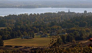
Oka is a small village on the northern bank of the Ottawa River, northwest of Montreal, Quebec, Canada. Located in the Laurentians valley on Lake of Two Mountains, where the Ottawa has its confluence with the St. Lawrence River, the town is connected via Quebec Route 344. It's located 50 km northwest of Montreal.

LIsle-aux-Coudres Municipality in Quebec, Canada

L'Isle-aux-Coudres is a municipality in Quebec, Canada, in the Charlevoix Regional County Municipality in the Charlevoix area of the Capitale-Nationale region. It is located on and contiguous with Coudres Island, located in the St. Lawrence River about 6 kilometres (3.7 mi) south from the mainland.

Château-Richer City in Quebec, Canada

Château-Richer is a small town situated in the Capitale-Nationale region of Quebec, Canada. Located on the north shore of the Saint Lawrence River east of Quebec City, Château-Richer is the seat for the Côte-de-Beaupré Regional County Municipality.

Sainte-Anne-de-la-Pérade Municipality in Quebec, Canada

Sainte-Anne-de-la-Pérade is a municipality in the Les Chenaux Regional County Municipality, in the Mauricie region of the province of Quebec in Canada. The town is located near the mouth of the Sainte-Anne River along the Chemin du Roy, a historic segment of Quebec Route 138 that stretches from near Montreal to Quebec City.

Pointe-à-la-Croix, Quebec Municipality in Quebec, Canada

Pointe-à-la-Croix is a municipality located on the Restigouche River in the Gaspésie region of eastern Quebec, Canada. It is situated across from the city of Campbellton, New Brunswick.

Saint-Ubalde Municipality in Quebec, Canada

Saint-Ubalde is a rural municipality in Portneuf County in the Canadian province of Quebec.

Bois-des-Filion City in Quebec, Canada

Bois-des-Filion is an off-island suburb of Montreal, located in Quebec, Canada, to the north of Montreal.

Batiscan, Quebec Municipality in Quebec, Canada

Batiscan is a municipality in the Mauricie region of the province of Quebec in Canada. It is located along the Saint Lawrence River at the mouth of the Batiscan River.

Champlain, Quebec Municipality in Quebec, Canada

Champlain is a municipality in the province of Quebec, Canada. It is located in Les Chenaux Regional County Municipality and the administrative region the Mauricie, on the north shore of St. Lawrence River. Champlain is also part of the metropolitan area of Trois-Rivières.

Pointe-Calumet Municipality in Quebec, Canada

Pointe-Calumet is a municipality in the Canadian province of Quebec. The municipality is located within the Deux-Montagnes Regional County Municipality in the Laurentides region. It is situated about 30 minutes northwest of Montreal. Its population as of the 2006 Canadian Census is just over 6 000.

Saint-Placide, Quebec Municipality in Quebec, Canada

Saint-Placide is a municipality in the Laurentides region of Quebec, Canada, part of the Deux-Montagnes Regional County Municipality, along the north shore of the Ottawa River.

Saint-Joseph-du-Lac Municipality in Quebec, Canada

Saint-Joseph-du-Lac is a municipality in the Laurentides region of Quebec, Canada, part of the Deux-Montagnes Regional County Municipality.

Saint-Lambert-de-Lauzon, Quebec Municipality in Quebec, Canada

Saint-Lambert-de-Lauzon is a municipality in La Nouvelle-Beauce Regional County Municipality in Quebec, Canada. It is part of the Chaudière-Appalaches region and the population is 6,177 as of the Canada 2011 Census. Prior to June 22, 2013 it was a parish municipality.

Les Éboulements Municipality in Quebec, Canada

Les Éboulements is a municipality in the Capitale-Nationale region of Quebec, Canada.

The rivière à Matte is a tributary of the northwest shore of the St. Lawrence River, flowing in the municipality of Neuville, in the Portneuf Regional County Municipality, in the administrative region of Capitale-Nationale, in the province, in Quebec, in Canada.

References

  1. 1 2 3 4 5 "Neuville (ville)" (in French). Commission de toponymie du Québec. Retrieved 2010-03-26.
  2. 1 2 Ministère des Affaires municipales, des Régions et de l'Occupation du territoire – Répertoire des municipalités: Neuville Archived 2013-06-25 at the Wayback Machine
  3. 1 2 Statistics Canada (March 10, 2009). "2016 Community profiles – Neuville" . Retrieved 2009-04-15.
  4. Statistics Canada: 1996, 2001, 2006, 2011, 2016 census

Commons-logo.svg Media related to Neuville, Quebec at Wikimedia Commons