The Arctic Archipelago, also known as the Canadian Arctic Archipelago, is a group of islands north of the Canadian mainland.

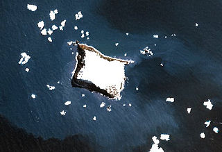
Candlemas Island is a small uninhabited island of the Candlemas Islands in the South Sandwich Islands. It lies about 2 miles (3.2 km) from Vindication Island, separated by the Nelson Channel.

Alejandro Selkirk Island, previously known as Más Afuera and renamed after the marooned sailor Alexander Selkirk, is the largest and most westerly island in the Juan Fernández Archipelago of the Valparaíso Region of Chile. It is situated 180 km west of Robinson Crusoe Island in the southeastern Pacific Ocean.

Annenkov Island is to the west of the main island of South Georgia. The Pickersgill Islands are to its southeast. It is irregularly shaped and 4 miles (6.4 km) long and 650 m (2,130 ft) high, lying 8 miles (13 km) off the south-central coast of South Georgia.
Yellowstone Crags is a group of crags which are locally eroded into striking pinnacles, situated 0. 5 miles (8 km) west of Sombre Point, Saunders Island, in the South Sandwich Islands. The name applied by United Kingdom Antarctic Place-Names Committee (UK-APC) in 1971 refers to the yellow color of the tuff rocks and their craggy topography.
Braces Point is the northeast point of Vindication Island, South Sandwich Islands. The feature was named Low Point during the survey from RRS Discovery II in 1930, but the name was changed to avoid duplication. The new name applied by the UK Antarctic Place-Names Committee in 1971 refers to the bifid form of this point, reaching out to the nearby sea stack of Trousers Rock.
Buddha Rock is a rock, 35 metres (115 ft) high, lying 0.3 nautical miles (0.6 km) west of Vindication Island in the South Sandwich Islands. It was charted and named in 1930 by Discovery Investigations personnel on the RSS Discovery II.
Cauldron Pool is a hot, brackish steaming pond located east of Tow Bay and below the west slopes of volcanically active Lucifer Hill, in northwest Candlemas Island, South Sandwich Islands. The descriptive name, suggestive of a cauldron, was applied by the UK Antarctic Place-Names Committee in 1971.
Chimaera Flats is a broad stretch of flat sand with a smooth surface only a few metres above sea level, between Medusa Pool and Gorgon Pool on Candlemas Island, South Sandwich Islands. The name applied by the UK Antarctic Place-Names Committee in 1971 refers to the chimaera, a mythical fire-eating monster.
Croft Bay is a bay which indents the north-central side of James Ross Island and forms the southern part of Herbert Sound, south of the northeastern end of the Antarctic Peninsula. It was discovered in 1903 by the Swedish Antarctic Expedition under Otto Nordenskiöld. It was charted in 1945 by the Falkland Islands Dependencies Survey (FIDS), who named it for W.N. Croft, a FIDS geologist at Hope Bay in 1946.
Crosscut Point is a series of jagged rocks forming the north end of Vindication Island in the South Sandwich Islands. It was charted in 1930 by Discovery Investigations personnel on the Discovery II, and so named because numerous crosscutting dikes have withstood weathering and produced this irregular formation.
Mount Perseus is the lower and more northerly of twin ice domes in the east part of Candlemas Island, South Sandwich Islands. Named by United Kingdom Antarctic Place-Names Committee (UK-APC) in 1971 in association with nearby Mount Andromeda. In Greek mythology, Perseus married Andromeda after rescuing her from a sea monster.
Gorgon Pool is a lake, or perhaps lagoon, between the Chimaera Flats and Kraken Cove in Candlemas Island, South Sandwich Islands. It was named by the UK Antarctic Place-Names Committee in association with nearby Medusa Pool. The Gorgon is a mythical creature of Homer's Iliad, linked in other mythology with Medusa.
Medusa Pool is a tidal lagoon which occupies the west side of the central lowlands of Candlemas Island in the South Sandwich Islands. The name, given by the UK Antarctic Place-Names Committee in 1971, is associated in classical mythology with the geomorphologically similar Gorgon Pool, nearby, Medusa being one of the gorgons.

The Marshall Archipelago is an extensive group of large ice-covered islands within the Sulzberger Ice Shelf off Antarctica. Several of the islands were discovered and plotted by the Byrd Antarctic Expeditions and by the United States Antarctic Service (1939–41), all led by Admiral Richard E. Byrd. The full extent of the archipelago was mapped by the United States Geological Survey from surveys and U.S. Navy air photos (1959–65). The name was proposed by Admiral Byrd for General of the Army George C. Marshall, who made financial contributions as a private individual and also, on the same basis, provided advisory assistance to the Byrd expedition of 1933–35.
Sombre Point is the northeast point of Saunders Island, South Sandwich Islands. The name applied by United Kingdom Antarctic Place-Names Committee (UK-APC) in 1971 refers to the dark and dull aspect of the basaltic rock and ash in this vicinity.
Holt Peak is a bare rock peak, 850 metres (2,800 ft) high, surmounting the northeast end of the Meyer Hills in the Heritage Range of Antarctica. It was mapped by the United States Geological Survey from surveys and U.S. Navy air photos from 1961 to 1966, and was named by the Advisory Committee on Antarctic Names for William C. Holt, a United States Antarctic Research Program auroral scientist at Ellsworth Station in 1961.