
A bog or bogland is a wetland that accumulates peat as a deposit of dead plant materials – often mosses, typically sphagnum moss. It is one of the four main types of wetlands. Other names for bogs include mire, mosses, quagmire, and muskeg; alkaline mires are called fens. A baygall is another type of bog found in the forest of the Gulf Coast states in the United States. They are often covered in heath or heather shrubs rooted in the sphagnum moss and peat. The gradual accumulation of decayed plant material in a bog functions as a carbon sink.

The Chequamegon–Nicolet National Forest is a 1,530,647-acre (6,194.31 km2) U.S. National Forest in northern Wisconsin in the United States. Due to logging in the early part of the 20th century, very little old growth forest remains. Some of the trees that grow there today were planted by the Civilian Conservation Corps in the 1930s. The national forest lands contain trees and vegetation corresponding to the North Woods Ecoregion that is prevalent throughout the upper Great Lakes region.
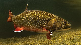
The brook trout is a species of freshwater fish in the char genus Salvelinus of the salmon family Salmonidae. It is native to Eastern North America in the United States and Canada, but has been introduced elsewhere in North America, as well as to Iceland, Europe, and Asia. In parts of its range, it is also known as the eastern brook trout, speckled trout, brook charr, squaretail, brookie or mud trout, among others. A potamodromous population in Lake Superior, as well as an anadromous population in Maine, is known as coaster trout or, simply, as coasters. The brook trout is the state fish of nine U.S. states: Michigan, New Hampshire, New Jersey, New York, North Carolina, Pennsylvania, Vermont, Virginia, and West Virginia, and the Provincial Fish of Nova Scotia in Canada.

Lake Khövsgöl is the largest freshwater lake in Mongolia by volume and second largest by area. It is located near the northern border of Mongolia, about 200 km west of the southern end of Lake Baikal. It is nicknamed the "Younger sister" of those two "sister lakes".
The Long Term Ecological Research Network(LTER) consists of a group of over 1800 scientists and students studying ecological processes over extended temporal and spatial scales. Twenty-eight LTER sites cover a diverse set of ecosystems. It is part of the International Long Term Ecological Research Network (ILTER). The project was established in 1980 and is funded by the National Science Foundation. Data from LTER sites is publicly available in the Environmental Data Initiative repository and findable through DataONE search.
The University of Georgia Marine Institute (UGAMI) is a nearshore ecological and geological research station located on Sapelo Island off the coast of Georgia in the United States. This island lies between the Atlantic Ocean and a pristine salt marsh. A ferry takes passengers from Meridian to Sapelo Island. The Island has fewer than 100 full-time residents. The Institute was created in 1953 and is currently a unit of the University of Georgia's Office of Research. The Institute is 280 miles southeast of the University of Georgia's main campus in Athens. UGAMI is world-renowned for its research on coastal marine and estuarine ecosystems.
Global Lake Ecological Observatory Network (GLEON) is an international grass-roots, voluntary network of researchers, educators, and community groups interested in making and utilizing time series of high-frequency observations made on and in lakes and reservoirs all over the world. GLEON includes more than 60 lake observatories and more than 850 individual members from 62 countries on six continents.
The Cedar Creek Ecosystem Science Reserve is an ecological research site located primarily in East Bethel, Minnesota in the counties of Anoka and Isanti on the northern edge of the Minneapolis-Saint Paul metropolitan area.

Harvard Forest is an ecological research area of 3,000 acres (12 km2) owned and managed by Harvard University and located in Petersham, Massachusetts. The property, in operation since 1907, includes one of North America's oldest managed forests, educational and research facilities, a museum, and recreation trails. Harvard Forest is open to the public.

Lough Talt is a lake in the Ox Mountains of south County Sligo, Ireland. The lake is located between the villages of Tubbercurry and Bonniconlon on the R294 road. Lough Talt is part of the Lough Hoe Bog Special Area of Conservation, an area of montane bogland and oligotrophic lakes.

Trout Lake is in Vilas County, Wisconsin, near the towns of Boulder Junction and Arbor Vitae, Wisconsin. With a surface area of 6.208 sq mi (16.079 km2) and a volume of 0.058 cu mi (0.240 km3), Trout Lake is one of the largest lakes in Vilas County. It has 16.1 mi (25.9 km) of shoreline, a large portion of which is undeveloped. There are also seven islands within the lake: Miller Island, Zimmerman Island, Haunted Island, Easter Island, Fisk Island, Chocolate Drop Island, and an unnamed island. It is a dimictic eutrophic lake that is highly productive and supports a large number of sport fish, which has made it a popular angling destination.
DataONE is a network of interoperable data repositories facilitating data sharing, data discovery, and open science. Originally supported by $21.2 million in funding from the US National Science Foundation as one of the initial DataNet programs in 2009, funding was renewed in 2014 through 2020 with an additional $15 million. DataONE helps preserve, access, use, and reuse of multi-discipline scientific data through the construction of primary cyberinfrastructure and an education and outreach program. DataONE provides scientific data archiving for ecological and environmental data produced by scientists. DataONE's goal is to preserve and provide access to multi-scale, multi-discipline, and multi-national data. Users include scientists, ecosystem managers, policy makers, students, educators, librarians, and the public.
The South African Environmental Observation Network (SAEON) is a science network of people, organisations and, most importantly observation platforms, that perform Long-Term Ecological Research (LTER) in South Africa and its surrounding oceans. The SAEON is of global importance as an innovative approach in ecology to understand environmental change and to determine the impact of anthropogenic forces at multiple scales but it is a remarkably complex challenge to statistically discern between ubiquitous natural variability and exogenous forcing. The SAEON constitutes a national government response to the World Summit on Sustainable Development and is a component of the GEO. The SAEON has become the leader in environmental science and observation in South Africa, but has been criticised for taking a long time to establish, a situation which was inevitable in view of SAEON's multiple stakeholder corps. It has also been raised that the cost of replicated experimental treatments across SAEON sites will be high.

Harris Station Dam is a hydroelectric dam in Northeast Somerset, Somerset County, Maine. Also known as the Indian Pond Project, the dam was built from 1952 to 1954 as the largest hydroelectric dam in the state of Maine. It impounds the Kennebec River at the southern end of the natural Indian Pond, about 12 miles (19 km) downstream from Moosehead Lake.
Vaikkojoki River is a 50-kilometre (31 mi) long river, which is in provinces of Northern Karelia and Northern Savonia.
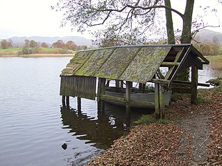
Blelham Tarn is a large valley tarn in the Lake District of England, to the north of the hill Latterbarrow. The settlements of Outgate, Low Wray and High Wray are close by. The tarn is drained to the northeast by the short Blelham Beck into Windermere. This beck was previously straightened and lowered. Fish species in the tarn include brown trout, eel, perch, pike and roach, much of the tarn shore is reedbed and waterfowl present can include great crested grebe, whooper swan and golden-eye.

Diane McKnight is a professor of civil, environmental, and architectural engineering at the University of Colorado Boulder and a fellow at the Institute of Arctic and Alpine Research (INSTAAR). McKnight is a founding principal investigator of the National Science Foundation's Long-Term Ecological Research (LTER) program in the McMurdo Dry Valleys of Antarctica.
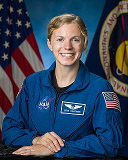
Zena Maria Cardman is an American geobiologist and NASA astronaut.

The Matamec River is a salmon river in the Côte-Nord region of Quebec, Canada. It empties into the Gulf of Saint Lawrence. The river was used for research into Atlantic salmon and brook trout by the Woods Hole Oceanographic Institution (WHOI) between 1966 and 1984. Today the southern part of the watershed is strictly protected by the Matamec Ecological Reserve..

The Réserve faunique des Chic-Chocs is a wildlife reserve of Quebec located in east of Parc national de la Gaspésie, in the administrative region of Gaspésie–Îles-de-la-Madeleine, in Quebec, Canada.

