
The Gulf of Saint Lawrence is the outlet of the North American Great Lakes via the Saint Lawrence River into the Atlantic Ocean. The gulf is a semi-enclosed sea, covering an area of about 226,000 square kilometres (87,000 sq mi) and containing about 34,500 cubic kilometres (8,300 cu mi) of water, which results in an average depth of 152 metres (499 ft).

The community of Hant's Harbour is an incorporated town having a population of 346 located on the east side of Trinity Bay on the Bay de Verde Peninsula, Newfoundland, Canada.

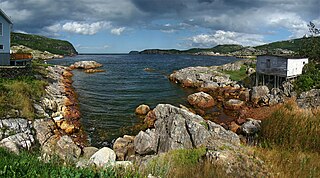
Sandy Cove, previously known as Savage Cove-Sandy Cove, is a town located on the Eastport Peninsula in Newfoundland and Labrador, Canada. It had a population of 132 in the 2011 census
Trinity Bight is a large area of the Northwestern portion of Trinity Bay, Newfoundland and Labrador, Canada. The bight contains the communities of New Bonaventure, Old Bonaventure, Trouty, Dunfield, Goose Cove, Trinity, Trinity East, Port Rexton, Champney's Arm, Champney's West, Champney's East, and English Harbour.
Keels is a small town in the Canadian province of Newfoundland and Labrador, located about 3 kilometres from Duntara. The population of this unincorporated community in the 2016 Canadian National Census was 51 down from 61 in 2011 and 73 in 2006. The earlier population figures show it had 85 in 2001, 101 in 1996, 128 in 1991, 115 in 1986, 206 in 1956 and 372 in 1940.
Dover is a small incorporated fishing and lumbering village located in a small cove at the head of Freshwater Bay, Bonavista Bay, Newfoundland, Canada. Settled in the early 1890s it was originally known as Shoal Bay, presumably from its many shallow coves and inlets in the area. From the 1950s to the 1970 Shoal Bay was referred to as Wellington , whereas the local residents called it Dover.
Duntara is a town located north west of Catalina, Newfoundland and Labrador. Duntara was an Incorporated Community on October 21, 1961. It had a population of 30 as of 2016.
Chance Cove is a town in the Canadian province of Newfoundland and Labrador. The town had a population of 256 in the Canada 2016 Census.
Heart's Desire is a town in the Canadian province of Newfoundland and Labrador. The town had a population of 226 in the Canada 2006 Census.
Little Catalina was a town in the Canadian province of Newfoundland and Labrador. The town had a population of 458 in the Canada 2006 Census.
Port Rexton is a small town in the Canadian province of Newfoundland and Labrador. It is located on the East Coast of the island of Newfoundland at the north end of Robinhood Bay, about 10 minutes east of Trinity and 3 hours north of St. John's. The town had a population of 690 in 1940, 449 in 1951, 454 in 1956, 351 in the Canada 2006 Census, 338 in the Canada 2011 Census and most recently 340 in the Canada 2016 Census. The town is part of a group of communities known as the Trinity Bight. The town is home to a few small businesses, including inns and restaurants.
Salvage is a town in the Canadian province of Newfoundland and Labrador. The town had a population of 174 in the Canada 2006 Census.
Sandringham is a town in the Canadian province of Newfoundland and Labrador. It is home to Terra Nova National Park. The town had a population of 255 in the Canada 2006 Census.
St. Brendan's is a town in the Canadian province of Newfoundland and Labrador. The town had a population of 145 in the Canada 2016 Census.
Lockston was a settlement located southwest of Catalina. It may, these days, perhaps be better considered as an 'area' with a sizable amount of summer cabins and a small permanent population.

Trinity East, Newfoundland and Labrador is a village located south west of Catalina, on the Bonavista Peninsula. Trinity East is an unincorporated community. The Way Office was established in 1879. The population was 188 in 1951 and 236 in 1956.

Fox Point is a settlement in Newfoundland and Labrador.
Deadman's Bay is a natural bay off the island of Newfoundland in the province of Newfoundland and Labrador, Canada.
Goose Bay is a natural bay off the island of Newfoundland in the province of Newfoundland and Labrador, Canada.

Division No. 1, Subdivision G is an unorganized subdivision on the Avalon Peninsula in Newfoundland and Labrador, Canada. It is in Division 1 and contains the unincorporated communities of Baccalieu Island, Besom Cove, Bradley's Cove, Burnt Point, Caplin Cove, Daniel's Cove, Grates Cove, Gull Island, Job's Cove, Kingston, Long Beach, Lower Island Cove, Low Point, Northern Bay, Ochre Pit Cove, Red Head Cove, Riverhead, Smooth Cove and Western Bay.