Çekerek is a town and district of Yozgat Province in the Central Anatolia region of Turkey. It is located in northeast of Yozgat province and it is 90 km far from there. According to 2013 census, population of the district is 23,699 of which 10,736 live in the town of Çekerek and remaining 12,963 people live in rural areas.

Nayoro City University is a public university in Nayoro, Hokkaido, Japan. The school was established as a junior women's college in 1960, and it became a four-year college in 2006.

Linkou Plateau is located along the southwest side of Tamsui River in New Taipei, Taiwan. It faces the Taipei Basin on the east, Taoyuan Plateau on the southwest, Taiwan Strait on the west, and the Tatun Volcanoes on the northeast. The Xinzhuang Fault (新莊斷層) and Shanjiao Fault (山腳斷層) are passed between the plateau and Taipei Basin.
Czosaki-Dąb is a village in the administrative district of Gmina Kołaki Kościelne, within Zambrów County, Podlaskie Voivodeship, in north-eastern Poland.
Mocówka is a village in the administrative district of Gmina Łabunie, within Zamość County, Lublin Voivodeship, in eastern Poland.

Józefin is a village in the administrative district of Gmina Poświętne, within Wołomin County, Masovian Voivodeship, in east-central Poland.

Hirehalli is a village in the southern state of Karnataka, India. It is located in the Challakere taluk of Chitradurga district in Karnataka.
Healabhal Bheag is a hill located on the Duirinish peninsula of Skye in the Inner Hebrides. It is also known as MacLeod's Table South and is part of the prominent pair of peaks known as MacLeod's Tables that dominate the views to the west of Dunvegan and to the north of the Harlosh peninsula.
Kamadolli is a village in the southern state of Karnataka, India. It is located in the Kundgol taluk of Dharwad district in Karnataka. It is located about 30 km from the city of Hubli and about 200 km from the city of Panjim in Goa.
Karjagi is a village in the southern state of Karnataka, India. It is located in the Haveri taluk of Haveri district in Karnataka.
Ružići is a village in a municipality of Grude, Bosnia and Herzegovina.
Shiragaon is a village in Hukkeri taluka of Belagavi district of Karnataka, India.
Shirhatti (Kh) is a village in Belgaum district of Karnataka, India.
Shivapeth is a village in Belgaum district of Karnataka, India.

The Klinikum St. Georg is the oldest, and, after Leipzig University Hospital, the second largest hospital in Leipzig, Germany. It consists of the Klinikum St. Georg gGmbH, and the Municipal Hospital "St. Georg" Leipzig. The hospital currently employs over 3,000 people and has nearly 1,200 beds in 25 clinics. In addition, the gGmbH and the municipal hospital function as an academic teaching hospital of Leipzig University.

Romanov Palace also known as Likani Palace, is a palace located in Likani, Georgia. Currently it serves as an official residence of the President of Georgia. The palace was designed by Leon Benois for Grand Duke Nicholas Mikhailovich of Russia.
Kotlajići is a village in Pljevlja Municipality, in northern Montenegro. According to the 2003 census, the village had a population of 54 people.
Dongfu railway station is a railway station belonging to Jilin–Shulan Railway and located in the Shulan of Jilin, Jilin province, China.
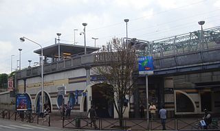
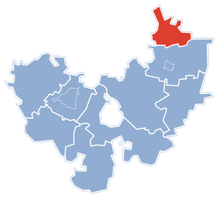
La Courneuve - Aubervilliers is an RER station located in La Courneuve and near of Aubervilliers in north suburb of Paris, in Seine-Saint-Denis department, France. The station is in Zone 3 of the Carte orange. It is situated on the RER B suburban railway line.
The Holy Trinity Cathedral Also Autlán Cathedral Is a religious building of the Catholic Church that functions as the headquarters of the Diocese of Autlán in Mexico. Raised in the late nineteenth century, the structure had a slow build.