Janina is a village in the administrative district of Gmina Bełchatów, within Bełchatów County, Łódź Voivodeship, in central Poland. It lies approximately 8 kilometres (5 mi) east of Bełchatów and 49 km (30 mi) south of the regional capital Łódź.
Lipna is a village in the administrative district of Gmina Sękowa, within Gorlice County, Lesser Poland Voivodeship, in southern Poland, close to the border with Slovakia. It lies approximately 19 kilometres (12 mi) south-east of Sękowa, 25 km (16 mi) south-east of Gorlice, and 122 km (76 mi) south-east of the regional capital Kraków.
Łosie is a village in the administrative district of Gmina Łabowa, within Nowy Sącz County, Lesser Poland Voivodeship, in southern Poland. It lies approximately 9 kilometres (6 mi) south-east of Łabowa, 24 km (15 mi) south-east of Nowy Sącz, and 97 km (60 mi) south-east of the regional capital Kraków.
Cieszyn is a village in the administrative district of Gmina Grabowiec, within Zamość County, Lublin Voivodeship, in eastern Poland. It lies approximately 6 kilometres (4 mi) west of Grabowiec, 19 km (12 mi) north-east of Zamość, and 79 km (49 mi) south-east of the regional capital Lublin.

Głębowice is a village in the administrative district of Gmina Osiek, within Oświęcim County, Lesser Poland Voivodeship, in southern Poland. It lies approximately 5 kilometres (3 mi) east of Osiek, 14 km (9 mi) south-east of Oświęcim, and 46 km (29 mi) west of the regional capital Kraków.
Łazy is a village in the administrative district of Gmina Oświęcim, within Oświęcim County, Lesser Poland Voivodeship, in southern Poland. It lies approximately 8 kilometres (5 mi) south of Oświęcim and 49 km (30 mi) west of the regional capital Kraków.

Graboszyce is a village in the administrative district of Gmina Zator, within Oświęcim County, Lesser Poland Voivodeship, in southern Poland. It lies approximately 6 kilometres (4 mi) south of Zator, 20 km (12 mi) south-east of Oświęcim, and 38 km (24 mi) west of the regional capital Kraków.
Grodzisko is a village in the administrative district of Gmina Zator, within Oświęcim County, Lesser Poland Voivodeship, in southern Poland. It lies approximately 5 kilometres (3 mi) south of Zator, 19 km (12 mi) south-east of Oświęcim, and 36 km (22 mi) west of the regional capital Kraków.
Laskowa is a village in the administrative district of Gmina Zator, within Oświęcim County, Lesser Poland Voivodeship, in southern Poland. It lies approximately 3 kilometres (2 mi) south-east of Zator, 19 km (12 mi) south-east of Oświęcim, and 35 km (22 mi) west of the regional capital Kraków.
Łowiczki is a village in the administrative district of Gmina Zator, within Oświęcim County, Lesser Poland Voivodeship, in southern Poland. It lies approximately 4 kilometres (2 mi) south-west of Zator, 16 km (10 mi) south-east of Oświęcim, and 39 km (24 mi) west of the regional capital Kraków.
Palczowice is a village in the administrative district of Gmina Zator, within Oświęcim County, Lesser Poland Voivodeship, in southern Poland. It lies approximately 17 km (11 mi) east of Oświęcim and 36 km (22 mi) west of the regional capital Kraków.
Podolsze is a village in the administrative district of Gmina Zator, within Oświęcim County, Lesser Poland Voivodeship, in southern Poland. It lies approximately 3 kilometres (2 mi) north of Zator, 15 km (9 mi) east of Oświęcim, and 37 km (23 mi) west of the regional capital Kraków.
Rudze is a village in the administrative district of Gmina Zator, within Oświęcim County, Lesser Poland Voivodeship, in southern Poland. It lies approximately 2 kilometres (1 mi) south-east of Zator, 18 km (11 mi) south-east of Oświęcim, and 36 km (22 mi) west of the regional capital Kraków.
Smolice is a village in the administrative district of Gmina Zator, within Oświęcim County, Lesser Poland Voivodeship, in southern Poland. It lies approximately 5 kilometres (3 mi) north-east of Zator, 17 km (11 mi) east of Oświęcim, and 34 km (21 mi) west of the regional capital Kraków.
Zaleska Wola is a village in the administrative district of Gmina Radymno, within Jarosław County, Subcarpathian Voivodeship, in south-eastern Poland, close to the border with Ukraine. It lies approximately 13 kilometres (8 mi) east of Radymno, 23 km (14 mi) east of Jarosław, and 71 km (44 mi) east of the regional capital Rzeszów.
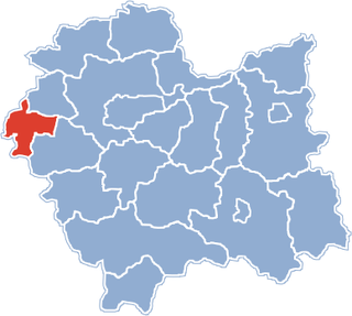
Polanka Wielka is a village in Oświęcim County, Lesser Poland Voivodeship, in southern Poland. It is the seat of the gmina called Gmina Polanka Wielka. It lies approximately 10 kilometres (6 mi) south-east of Oświęcim and 46 km (29 mi) west of the regional capital Kraków.
Seroki is a village in the administrative district of Gmina Lutocin, within Żuromin County, Masovian Voivodeship, in east-central Poland. It lies approximately 4 kilometres (2 mi) east of Lutocin, 11 km (7 mi) south-west of Żuromin, and 117 km (73 mi) north-west of Warsaw.
Koczarki is a village in the administrative district of Gmina Kętrzyn, within Kętrzyn County, Warmian-Masurian Voivodeship, in northern Poland. It lies approximately 13 kilometres (8 mi) south-east of Kętrzyn and 68 km (42 mi) east of the regional capital Olsztyn.