Błonie is a village in the administrative district of Gmina Wielgomłyny, within Radomsko County, Łódź Voivodeship, in central Poland. It lies approximately 8 kilometres (5 mi) south-east of Wielgomłyny, 29 km (18 mi) south-east of Radomsko, and 96 km (60 mi) south of the regional capital Łódź.
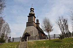
Krzęcin is a village in the administrative district of Gmina Skawina, within Kraków County, Lesser Poland Voivodeship, in southern Poland. It lies approximately 8 kilometres (5 mi) south-west of Skawina and 19 km (12 mi) south-west of the regional capital Kraków.
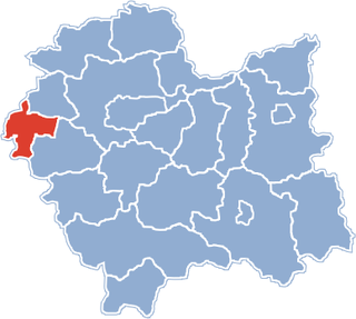
Łęki is a village in the administrative district of Gmina Kęty, within Oświęcim County, Lesser Poland Voivodeship, in southern Poland. It lies approximately 6 kilometres (4 mi) north of Kęty, 12 km (7 mi) south of Oświęcim, and 54 km (34 mi) west of the regional capital Kraków.

Głębowice is a village in the administrative district of Gmina Osiek, within Oświęcim County, Lesser Poland Voivodeship, in southern Poland. It lies approximately 5 kilometres (3 mi) east of Osiek, 14 km (9 mi) south-east of Oświęcim, and 46 km (29 mi) west of the regional capital Kraków.
Łazy is a village in the administrative district of Gmina Oświęcim, within Oświęcim County, Lesser Poland Voivodeship, in southern Poland. It lies approximately 8 kilometres (5 mi) south of Oświęcim and 49 km (30 mi) west of the regional capital Kraków.
Grodzisko is a village in the administrative district of Gmina Zator, within Oświęcim County, Lesser Poland Voivodeship, in southern Poland. It lies approximately 5 kilometres (3 mi) south of Zator, 19 km (12 mi) south-east of Oświęcim, and 36 km (22 mi) west of the regional capital Kraków.
Laskowa is a village in the administrative district of Gmina Zator, within Oświęcim County, Lesser Poland Voivodeship, in southern Poland. It lies approximately 3 kilometres (2 mi) south-east of Zator, 19 km (12 mi) south-east of Oświęcim, and 35 km (22 mi) west of the regional capital Kraków.
Łowiczki is a village in the administrative district of Gmina Zator, within Oświęcim County, Lesser Poland Voivodeship, in southern Poland. It lies approximately 4 kilometres (2 mi) south-west of Zator, 16 km (10 mi) south-east of Oświęcim, and 39 km (24 mi) west of the regional capital Kraków.
Palczowice is a village in the administrative district of Gmina Zator, within Oświęcim County, Lesser Poland Voivodeship, in southern Poland. It lies approximately 17 km (11 mi) east of Oświęcim and 36 km (22 mi) west of the regional capital Kraków.
Podolsze is a village in the administrative district of Gmina Zator, within Oświęcim County, Lesser Poland Voivodeship, in southern Poland. It lies approximately 3 kilometres (2 mi) north of Zator, 15 km (9 mi) east of Oświęcim, and 37 km (23 mi) west of the regional capital Kraków.
Rudze is a village in the administrative district of Gmina Zator, within Oświęcim County, Lesser Poland Voivodeship, in southern Poland. It lies approximately 2 kilometres (1 mi) south-east of Zator, 18 km (11 mi) south-east of Oświęcim, and 36 km (22 mi) west of the regional capital Kraków.
Smolice is a village in the administrative district of Gmina Zator, within Oświęcim County, Lesser Poland Voivodeship, in southern Poland. It lies approximately 5 kilometres (3 mi) north-east of Zator, 17 km (11 mi) east of Oświęcim, and 34 km (21 mi) west of the regional capital Kraków.
Trzebieńczyce is a village in the administrative district of Gmina Zator, within Oświęcim County, Lesser Poland Voivodeship, in southern Poland. It lies approximately 3 kilometres (2 mi) south-east of Zator, 19 km (12 mi) south-east of Oświęcim, and 35 km (22 mi) west of the regional capital Kraków.
Marcyporęba is a village in the administrative district of Gmina Brzeźnica, within Wadowice County, Lesser Poland Voivodeship, in southern Poland. It lies approximately 3 kilometres (2 mi) south-west of Brzeźnica, 12 km (7 mi) north-east of Wadowice, and 27 km (17 mi) south-west of the regional capital Kraków.
Sosnowice is a village in the administrative district of Gmina Brzeźnica, within Wadowice County, Lesser Poland Voivodeship, in southern Poland. It lies approximately 7 kilometres (4 mi) east of Brzeźnica, 18 km (11 mi) north-east of Wadowice, and 21 km (13 mi) south-west of the regional capital Kraków.
Książnice is a village in the administrative district of Gmina Gdów, within Wieliczka County, Lesser Poland Voivodeship, in southern Poland. It lies approximately 10 kilometres (6 mi) north-east of Gdów, 19 km (12 mi) east of Wieliczka, and 30 km (19 mi) south-east of the regional capital Kraków.
Polanka Wielka is a village in Oświęcim County, Lesser Poland Voivodeship, in southern Poland. It is the seat of the gmina called Gmina Polanka Wielka. It lies approximately 10 kilometres (6 mi) south-east of Oświęcim and 46 km (29 mi) west of the regional capital Kraków.
Błota is a village in the administrative district of Gmina Lubsza, within Brzeg County, Opole Voivodeship, in south-western Poland. It lies approximately 6 kilometres (4 mi) north-west of Lubsza, 10 km (6 mi) north of Brzeg, and 47 km (29 mi) north-west of the regional capital Opole.
Barcikowo is a village in the administrative district of Gmina Dobre Miasto, within Olsztyn County, Warmian-Masurian Voivodeship, in northern Poland. It lies approximately 6 kilometres (4 mi) south-east of Dobre Miasto and 19 km (12 mi) north of the regional capital Olsztyn.