Zlatitsa is a town and the seat of the Zlatitsa Municipality in southern Bulgaria located in the Zlatitsa-Pirdop valley. It lies between Stara Planina to the north and Sredna Gora to the south at 680 metres (2,230 ft) above sea level. It is situated immediately south in the lap of the Zlatitsa -Teteven Mountain. Zlatitsa is situated 75 kilometres (47 mi) east of Sofia, 27 kilometres (17 mi) south of Etropole, 32 kilometres (20 mi) north of Panagiurishte, 2 kilometres (1.2 mi) west of Pirdop and 32 kilometres (20 mi) northwest of Koprivshtitsa. The population is 5,286.

Krushari is a village in northeastern Bulgaria, part of Dobrich Province. It is the administrative centre of Krushari Municipality, which lies in the northwestern part of the province. Krushari is located 32 kilometres from the provincial capital of Dobrich, 85 kilometres from Varna and around 70 kilometres from Balchik and Silistra.
Avramovo is a village in Ardino Municipality, Kardzhali Province, in southern-central Bulgaria. It is located 187.5 kilometres (116.5 mi) from Sofia, roughly 14 kilometres (8.7 mi) by road southwest of the city of Kardzhali, and roughly 20 kilometres (12 mi) by road east of the municipal town of Ardino.Boyno lies just to the east along the 865 road. It covers an area of 6.197 square kilometres (2.393 sq mi) and as of 2007 had a population of 6 people. Until 1934, the settlement had the name Ibrahimler.
Chubrika is a village in Ardino Municipality, Kardzhali Province, southern-central Bulgaria. It is located 199.97 kilometres (124.26 mi) from Sofia, roughly 21.3 kilometres (13.2 mi) by road southwest of the city of Kardzhali, and roughly 13 kilometres (8.1 mi) by road east of the municipal town of Ardino. To the north is Yabalkovets and to the northeast is Kobilyane, along the 865 road. It covers an area of 5.782 square kilometres (2.232 sq mi) and as of 2007 had a population of 153 people. It was formerly called Fakrŭ Bunar.
Yabalkovets is a mountain village in Ardino Municipality, Kardzhali Province, southern-central Bulgaria. It is located 199.97 kilometres (124.26 mi) from Sofia, and roughly 16 kilometres (9.9 mi) by road northeast of the municipal town of Ardino. To the southeast is Chubrika. It covers an area of 11.232 square kilometres and as of 2013 had a population of 204 people.
Sinchets is a small mountain village in Ardino Municipality, Kardzhali Province, southern-central Bulgaria. It is located 199.967 kilometres (124.254 mi) from Sofia. It lies at altitude of 770 metres (2,530 ft), 9.8 kilometres (6.1 mi) by winding road to the southeast of Ardino, and north of Tsarkvitsa. It covers an area of 8.602 square kilometres and as of 2007 had a population of 70 people.
Gurbishte is a mountain village in Ardino Municipality, Kardzhali Province, southern-central Bulgaria. It is located 196.78 kilometres (122.27 mi) from Sofia and 13.6 kilometres (8.5 mi) by winding road south of Ardino. It lies to the southwest of Sinchets, and northeast of Padina. It covers an area of 14.494 square kilometres and as of 2007 had a population of 183 people. The village contains a village hall.

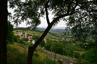
Padina is a village in Ardino Municipality, Kardzhali Province, southern-central Bulgaria, located in a valley at the foot of Mount St. Elias (1001m). It is located 195.32 kilometres (121.37 mi) from Sofia,14.8 kilometres (9.2 mi) southwest of Ardino, and 4.8 kilometres (3.0 mi) by road south of Byal izvor. It covers an area of 10.411 square kilometres and as of 2007 had a population of 1030 people, although the population is rapidly declining and 851 were reported in 2010.
Ahryansko is a village in Ardino Municipality, Kardzhali Province, southern-central Bulgaria. It is located 191.083 kilometres (118.733 mi) from Sofia. It covers an area of 6.839 square kilometres and as of 2007 had a population of 51 people.
Borovitsa is a village in Ardino Municipality, Kardzhali Province, southern-central Bulgaria. It is located 194.207 kilometres (120.675 mi) from Sofia. It covers an area of 12.667 square kilometres and as of 2007 had a population of 297 people.
Glavnik is a village in Ardino Municipality, Kardzhali Province, southern-central Bulgaria. It is located 200.247 kilometres (124.428 mi) from Sofia. It covers an area of 1.795 square kilometres and as of 2007 had a population of 127 people.
Kitnitsa is a village in Ardino Municipality, Kardzhali Province, southern-central Bulgaria. It is located 188.619 kilometres (117.202 mi) southeast of Sofia. It covers an area of 11.586 square kilometres and as of 2007 it had a population of 97 people.
Kroyachevo is a village in Ardino Municipality, Kardzhali Province, southern-central Bulgaria. It is located 193.336 kilometres (120.133 mi) southeast of Sofia. It covers an area of 5.183 square kilometres and as of 2007 it had a population of 104 people.
Latinka is a village in Ardino Municipality, Kardzhali Province, southern-central Bulgaria. It is located 193.336 kilometres (120.133 mi) southeast of Sofia. It covers an area of 10.652 square kilometres and as of 2007 it had a population of 22 people.
Lenishte is a village in Ardino Municipality, Kardzhali Province, southern-central Bulgaria. It is located 201.18 kilometres (125.01 mi) southeast of Sofia. It covers an area of 13.487 square kilometres and as of 2007 it had a population of 122 people.
Mlechino is a village in Ardino Municipality, Kardzhali Province, southern-central Bulgaria. It is located 194.184 kilometres (120.660 mi) southeast of Sofia. It covers an area of 5.423 square kilometres and as of 2007 it had a population of 314 people.
Svetulka is a village in Ardino Municipality, Kardzhali Province, southern-central Bulgaria. It is located 192.393 kilometres (119.547 mi) southeast of Sofia. It covers an area of 7.624 square kilometres and as of 2007 it had a population of 182 people.
Stoyanovo is a village in Ardino Municipality, Kardzhali Province, southern-central Bulgaria. It is located 187.023 kilometres (116.211 mi) southeast of Sofia. It covers an area of 5.974 square kilometres and as of 2013 it had a population of 21 people.
Borovsko is a village in Chernoochene Municipality, in Kardzhali Province, in southern-central Bulgaria. It is located 189.883 kilometres (117.988 mi) southeast of Sofia. It covers an area of 4.021 square kilometres and as of 2007 it had a population of 19 people.
Minzuhar is a village in Chernoochene Municipality, in Kardzhali Province, in southern-central Bulgaria. It is located 199.48 kilometres (123.95 mi) southeast of Sofia. It covers an area of 8.581 square kilometres and as of 2007 it had a population of 470 people.