
Ghanzi is a district in western Botswana, bordering Namibia in the west and extending east into much of the interior of the country. The district's administrative centre is the town of Ghanzi. Most of the eastern half of Ghanzi makes up the Central Kalahari Game Reserve. The human population at the 2001 census was 43,370, less populous than that of any other district in Botswana. Ghanzi's area is 117,910 km².

The North-East District is one of the administrative districts of Botswana. Its capital is Francistown. In 2011, North-East had a population of 60,264 people. The district is predominantly occupied by Kalanga-speaking people, the BaKalanga. The district is administered by a district administration and district council, which are responsible for local administration.

The North-West District or Ngamiland is one of the first-level administrative subdivisions of Botswana. For census and administrative purposes Ngamiland is subdivided into Ngamiland East, Ngamiland West and Ngamiland Delta (Okavango). It is governed by a District Commissioner, appointed by the national government, and the elected North-West District Council. The administrative centre is Maun.
Kgatleng is one of the districts of Botswana, coterminous with the homeland of the Bakgatla people. Its capital is Mochudi, the hometown of protagonist Precious Ramotswe in Alexander McCall Smith's popular The No. 1 Ladies' Detective Agency series. According to the 2001 Census, Kgatleng had a population of 73,507 people.
South-East is one of the districts of Botswana. The capital city of Botswana, Gaborone, is surrounded by this district. The administrative capital for the South-East district is the village of Ramotswa. In the southeast, South-East borders the North West Province of South Africa. Domestically, it borders Kgatleng in northeast, Kweneng in northwest, Southern in southwest.

Central is the largest of Botswana's districts in terms of area and population. It encompasses the traditional homeland of the Bamangwato people. Some of the most politically connected Batswana have come from the Central District, including former President Sir Seretse Khama, former President Festus Mogae, and former President Lt. General Seretse Ian Khama. The district borders the Botswanan districts of Chobe in the north, North-West in the northwest, Ghanzi in the west, Kweneng in southwest, Kgatleng in the south and North-East in the northeast, as well as Zimbabwe also in the northeast and South Africa in the southeast.
Bobonong is a town in the Central District of Botswana 80 km from Selibe Phikwe town. Bobonong has a population of around 19,000. The Babirwa tribe can be found in this town. The Botswana Pink semi-precious stones can be found in Bobonong region. The Babirwa are known for harvesting the mophane worm. The locals refer to the town as Bobcity or formerly Lekgarapeng, which was derived from the stoney landscape of the town.

The Shashe River is a major left-bank tributary of the Limpopo River in Zimbabwe. It rises northwest of Francistown, Botswana and flows into the Limpopo River where Botswana, Zimbabwe and South Africa meet. The confluence is at the site of the Greater Mapungubwe Transfrontier Conservation Area.
Tshokwe is a village in Central District of Botswana. The village is located south-east of Francistown, near the border with Zimbabwe, and it has a primary school. The population was 897 according to the 2001 census.
An Australian company, DiamonEx Limited, opened a diamond mine 15 km (9 mi) north-west of the village of Lerala in Botswana. The mine initially known as Martins Drift Diamond Project opened early 2008 and was to employ 230–290 people to produce an estimated 330,000 carats (66 kg) per year.

The Notwane River is a river in southeastern Botswana. Certain sections of its course form the international boundary with South Africa. Its mouth is at the head of the Limpopo River. It has a catchment area of 18,053 square kilometres (6,970 sq mi).
The Eloyi Christian Church was founded by Archbishop Jakoba Keiphile -a-Seduma in 1955 in the small village of Tsetsebjwe, to the southeast of Selebi Phikwe in Botswana. The Church has since spread across Botswana and into neighboring countries like South Africa and Zimbabwe. It has attracted much attention for its dramatic scenes and exorcisms of demons.
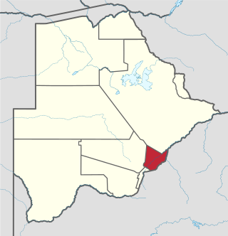
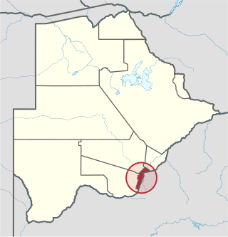
The Bobirwa Subdistrict is a jurisdiction in Botswana. It is populated by the Babirwa (Ba-Birwa) people who came from Transvaal in present-day South Africa.
The Letsibogo Dam is a dam on the Motloutse River in Botswana, built to initially provide water to the industrial town of Selebi-Phikwe and surrounding areas, with the potential for use in irrigation. The dam now supplies Gaborone, the capital of the country, via a 400 kilometres (250 mi) pipeline, as well as major villages along the pipeline route.
Moremi is a village in the Central District of Botswana, about 40 kilometres (25 mi) east of Palapye. The village lies in a bend of the Lotsane River, a seasonal tributary of the Limpopo River. It lies just north of the dramatic Tswapong Hills.
The Thune Dam is a dam on the Thune River in Botswana that was under construction in 2012. It has a planned capacity of 90,000,000 cubic metres (3.2×10⁹ cu ft).
The Dikgatlhong Dam is a dam near the village of Robelela on the Shashe River in Botswana, completed in December 2011. When full it will hold 400,000,000 cubic metres (1.4×10¹⁰ cu ft). The next largest dam in Botswana, the Gaborone Dam, has capacity of 141,000,000 cubic metres (5.0×10⁹ cu ft).
Motlhabaneng is a village in Botswana on the north bank of the Motloutse River near the borders with South Africa and Zimbabwe. It is on the south-western boundary of the Northern Tuli Game Reserve.
Gobojango, locally known as Gobas, is a village in the Central District, Botswana; more specifically in the Bobirwa Sub-District.
Botswana continued to address the COVID-19 pandemic in 2021, beginning its vaccination process through the importation of vaccines. On November 11, Botswana was the location of the first documented case of the SARS-CoV-2 Omicron variant. 2021 also saw the discovery of two diamonds in Botswana that exceeded 1000 carats, becoming the third and fourth largest diamonds ever discovered. In relations with its neighbouring countries, Botswana continued to address violence at the Botswana–Namibia border, and it entered into the conflict in Cabo Delgado in support of the government of Mozambique.
