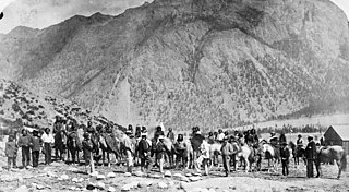
The Stʼatʼimc, also known as the Lillooet, St̓át̓imc, Stl'atl'imx, etc., are an Interior Salish people located in the southern Coast Mountains and Fraser Canyon region of the Interior of the Canadian province of British Columbia.

The Fraser Canyon is a major landform of the Fraser River where it descends rapidly through narrow rock gorges in the Coast Mountains en route from the Interior Plateau of British Columbia to the Fraser Valley. Colloquially, the term "Fraser Canyon" is often used to include the Thompson Canyon from Lytton to Ashcroft, since they form the same highway route which most people are familiar with, although it is actually reckoned to begin above Williams Lake, British Columbia at Soda Creek Canyon near the town of the same name.

The Clear Range is a small mountain range located in the angle of the Fraser and Thompson Rivers in south-central British Columbia. It has a small subdivision just northeast of that confluence named the Scarped Range. The Clear Range totals 16,270 km² (6,280 mi²) and is 75 km (47 mi) north to south and 35 km (22 mi) east to west. The Clear Range and its northward neighbour the Marble Range are both subranges of the Pavilion Range.
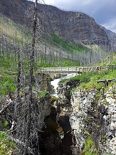
Marble Canyon is in the south-central Interior of British Columbia, a few kilometres east of the Fraser River and the community of Pavilion, midway between the towns of Lillooet and Cache Creek. The canyon stems from a collapsed karst formation.

A quiggly hole, also known as a pit-house or simply as a quiggly or kekuli, is the remains of an earth lodge built by the First Nations people of the Interior of British Columbia and the Columbia Plateau in the U.S. The word quiggly comes from kick willy or keekwulee, the Chinook Jargon word for "beneath" or "under".
The Lillooet Tribal Council is the official English name of the largest tribal council of what is also known as the St'at'imc Nation, though not including all governments of St'at'imc peoples - the term St'at'imc Nation has another context of all St'at'imc peoples, not just those within this tribal council or the tribal council itself, as the term can be used for. The Lillooet Tribal Council a.k.a. the St'at'imc Nation is the largest tribal council of the St'at'imc people, though a pan-St'at'imc organization, the St'át'timc Chiefs Council includes all St'at'imc bands.
The Bridge River Indian Band also known as the Nxwísten First Nation, the Xwisten First Nation, and the Bridge River Band, is a First Nations government located in the Central Interior-Fraser Canyon region of the Canadian province of British Columbia. It is a member of the Lillooet Tribal Council, which is the largest grouping of band governments of the St'at'imc people.

The Secwépemc, known in English as the Shuswap people, are a First Nations people residing in the interior of the Canadian province of British Columbia. They speak one of the Salishan languages, known as Secwepemc or Shuswap or.
Nicola, also Nkwala or N'kwala, was an important First Nations political figure in the fur trade era of the British Columbia Interior as well as into the colonial period (1858–1871). He was grand chief of the Okanagan people and chief of the Nicola Valley peoples, an alliance of Nlaka'pamux and Okanagans and the surviving Nicola Athapaskans, and also of the Kamloops Band of the Shuswap people.
The Shuswap Nation Tribal Council is a First Nations Tribal Council in the Canadian province of British Columbia. Based in the Thompson and Shuswap Districts of the Central Interior, although including one band on the upper Columbia River in the East Kootenay region. It is one of two tribal councils of the Secwepemc people, the other being the Northern Shuswap Tribal Council of the Cariboo region farther to the north. The council is based in Kamloops, British Columbia.
The High Bar First Nation is a First Nations government of the Secwepemc (Shuswap) Nation, located in the Fraser Canyon-Cariboo region of the Central Interior of the Canadian province of British Columbia. It was created when the government of the then-Colony of British Columbia established an Indian Reserve system in the 1860s. It is one of three Secwepemc bands that is not a member of either the Shuswap Nation Tribal Council or the Northern Shuswap Tribal Council. The High Bar people are also partly Tsilhqot'in and have links with some Chilcotin First Nations.
The Pavilion Indian Band or Ts'kw'aylaxw First Nation or Tsk'waylacw First Nation or Tsk'weylecw First Nation, and also known in the plural e.g. Ts'kw'alaxw First Nations, is a First Nations government, located in the Fraser Canyon region of the Central Interior of the Canadian province of British Columbia. It was created when the government of the then-Colony of British Columbia established an Indian Reserve system in the 1860s.
Xaxli'p, also known as the Fountain or the Fountain Indian Band, is a First Nations government located in the Central Interior-Fraser Canyon region of the Canadian province of British Columbia. It is a member of the Lillooet Tribal Council, which is the largest grouping of band governments of the St'at'imc people.

The Lil'wat First Nation, a.k.a. the Lil'wat Nation or the Mount Currie Indian Band, is a First Nation band government located in the southern Coast Mountains region of the Interior of the Canadian province of British Columbia. It is a member of the Lillooet Tribal Council, which is the largest grouping of band governments of the St'at'imc or Stl'atl'imx people. Other St'at'imc governments include the smaller In-SHUCK-ch Nation on the lower Lillooet River to the southwest, and the independent N'quatqua First Nation at the near end of Anderson Lake from Mount Currie, which is the main reserve of the Lil'wat First Nation, and also one of the largest Indian reserves by population in Canada.
The T'it'q'et First Nation also known as the T'it'k'it First Nation, the Tl'itl'kit First Nation and as the Lillooet Indian Band, is a First Nations government located in the Central Interior-Fraser Canyon region of the Canadian province of British Columbia. It is a member of the Lillooet Tribal Council, which is the largest grouping of band governments of the St'at'imc people. Other St'at'imc governments include the smaller In-SHUCK-ch Nation on the lower Lillooet River to the southwest, and the independent N'quatqua First Nation at the farther end of Anderson Lake from Seton Portage, which is the location of three of the reserve communities of the Seton Lake First Nation, another member of the Lillooet Tribal Council.
The N'Quatqua First Nation, also known as the N'quatqua Nation, the N'Quatqua Nation, the Nequatque First Nation, the Anderson Lake Indian Band, the Anderson Lake First Nation and the Anderson Lake Band, is a First Nations government of the St'at'imc people, located in the southern Coast Mountains region of the Canadian province of British Columbia at the community of D'Arcy, where the British Columbia Railway meets the head of Anderson Lake, about midway between the towns of Pemberton and Lillooet.
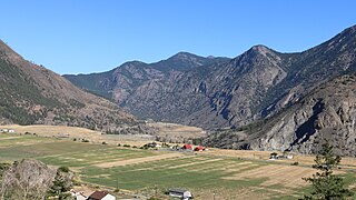
Fountain is an unincorporated rural area and Indian Reserve community in the Fraser Canyon region of British Columbia, Canada, located at the ten-mile (16 km) mark from the town of Lillooet on BC Highway 99, which in that area is also on the route of the Old Cariboo Road and is located at the junction of that route with the old gold rush-era trail via Fountain Valley and the Fountain Lakes.
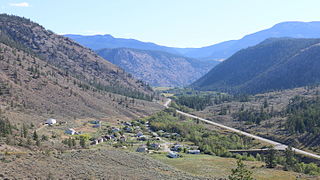
Pavilion is a ranching and Indian Reserve community in the Fraser Canyon area of British Columbia, Canada. Most of the community is the population of the Pavilion 1 Indian Reserve of the Pavilion Indian Band, a.k.a. the Ts'kw'aylaxw First Nation but there are also a number of ranches in the surrounding area, and a lakeshore recreational neighbourhood at nearby Pavilion Lake.

Pavilion Lake is a lake in Marble Canyon, British Columbia, Canada. It is located between the towns of Lillooet and Cache Creek and lies along BC Highway 99, 8.85 highway kilometres from Pavilion, British Columbia. Part of a karst formation, the lake is most notable for being home to colonies of microbialites, a type of stromatolite, and has become the subject of astrobiology research by NASA, the Canadian Space Agency, and research institutions from around the world. The research falls under the umbrella of the Pavilion Lake Research Project. The lake area and its foreshore were added to Marble Canyon Provincial Park in order to protect its special scientific and heritage values.
The Bridge River Rapids, also known as the Six Mile Rapids, the Lower Fountain, the Bridge River Fishing Grounds, and in the St'at'imcets language as Sat' or Setl, is a set of rapids on the Fraser River, located in the central Fraser Canyon at the mouth of the Bridge River six miles north of the confluence of Cayoosh Creek with the Fraser and on the northern outskirts of the District of Lillooet, British Columbia, Canada.