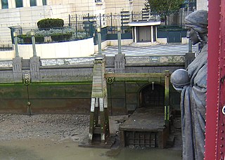
The River Effra is a former stream or small river in south London, England, now culverted for most of its course. Once a tributary of the River Thames, flows from the Effra were incorporated in the Victorian era into a combined sewer draining much of the historic area of Peckham and Brixton.

The River Quaggy is a river, 17 kilometres (11 mi) in length, passing through the south-east London boroughs of Bromley, Greenwich and Lewisham. In its lower reaches it is an urban river, in its upper reaches further from London it is more natural and known as the Kyd Brook. The river rises from two sources near Princess Royal University Hospital (PRUH) at Locksbottom and is a tributary of the River Ravensbourne which it flows into near Lewisham station in Lewisham.

Tuebrook is an North-East area of Liverpool, England. At the 2001 Census the population was 14,490.
The Frome, historically the Froom, is a river that rises in Dodington Park, South Gloucestershire, and flows south westerly through Bristol, joining the former course of the river Avon in Bristol's Floating Harbour. It is approximately 20 miles (32 km) long, and the mean flow at Frenchay is 60 cubic feet per second (1.7 m3/s). The name Frome is shared with several other rivers in South West England and means 'fair, fine, brisk’. The river is known locally in east Bristol as the Danny.

The River Leen is a 15-mile (24 km) long tributary of the River Trent that flows through Nottinghamshire, and the city of Nottingham in the East Midlands of England.

The River Alt is an urban river that flows across Merseyside in England. The river has suffered from heavy pollution from industry and sewage upstream and run-off from farmland in its lower reaches. It empties into the River Mersey, near to where the Mersey itself flows into the Irish Sea. the river has benefited from clean-up schemes and a de-culverting process to improve its water quality and provide a better environment for wildlife.

The River Blakewater is a river running through Lancashire, giving its name to the town of Blackburn.

The River Darwen is a river running through the towns of Darwen and Blackburn in Lancashire which eventually joins the River Ribble at Walton le Dale. Here the river runs to the south of Preston on its way to the Ribble Estuary on the west coast of northern England.
River Adda is a small watercourse which flows, through the city of Bangor North Wales before discharging into the Menai Strait at Hirael Bay, opposite Porth Penrhyn. The name is said to be of 19th-century origin, deriving from a field Cae Mab Adda close to its source. Its earlier name was Tarannon.

The River Calder is a major tributary of the River Ribble in Lancashire, England and is around 20 miles (32 km) in length.

The River Poddle is a river in Dublin, Ireland, a pool on which gave the city its English language name. Boosted by a channel made by the Abbey of St Thomas à Becket, taking water from the far larger River Dodder, the Poddle was the main source of drinking water for the city for more than 500 years, from the 1240s. The Poddle, which flows wholly within the traditional County Dublin, is one of around a hundred members of the River Liffey system, and one of over 135 rivers in the county; it had just one significant natural tributary, the Commons Water from Crumlin.

The Falconbrook is a stream that once rose in Balham and Tooting, draining most of that parish as well as the south of Battersea including Clapham Junction, and a narrow strip in the rest of Battersea where it entered the River Thames.

The Blackstaff River is a watercourse in County Antrim, Northern Ireland. It rises on the eastern slope of the Black Mountain before flowing down into the Bog Meadows and passing under the city of Belfast, where it enters the River Lagan. Much of its course has been culverted and built upon since the 19th century, making it largely invisible today. Its tributaries include the Forth or Clowney River, which meets it beneath the Broadway Roundabout in West Belfast.

Shire Brook is a small stream in the south eastern part of the City of Sheffield in South Yorkshire, England. It rises in the suburb of Gleadless Townend and flows in a general easterly direction for 4 miles (6.5 km) to its confluence with the River Rother between Beighton and Woodhouse Mill. In the past the brook has been both the border of Yorkshire and Derbyshire and between the sees of Canterbury and York. The course of the stream has been influenced by human intervention in the 20th century with the brook being diverted underground and flowing through culverts on three occasions as it traverses locations which were formerly landfill sites and extensive railway sidings.

The River Calder is in West Yorkshire, in Northern England.
Shit Brook is a culverted small stream in Much Wenlock, Shropshire, England.

The Markeaton Brook is an 11-mile-long (17 km) tributary of the River Derwent in Derbyshire, England. The brook rises from its source south of Hulland Ward, and flows for most of its length through the countryside north-west of Derby before entering a culvert to the north of the city centre; it reappears from this culvert and runs through a short section of open channel on the other side of the city before joining the Derwent.
The Old Garston River or Garston River, sometimes referred to as the Garston Brook, is a tributary of the River Mersey in Garston, Merseyside, a district of Liverpool. Having been encroached upon by urban development, it is now a subterranean river, culverted for all of its length, although unlike many culverted urban rivers it has not been incorporated into the sewer system.
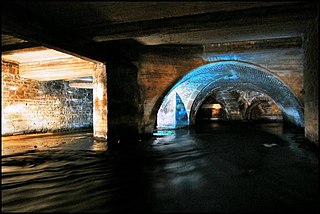
Bradford Beck is a river that flows through Bradford, West Yorkshire, England, and on to the River Aire at Shipley. As it reaches Bradford city centre it runs underground after being built over in the 19th century. It is culverted as it runs from Bradford city centre to Queen's Road after which it runs mostly in an open channel to Shipley. The beck used to be known as the filthiest river in England.
Walverden Water is a minor river in Lancashire, England. It is approximately 2.6 miles (4.2 km) long and has a catchment area of 5.04 square miles (1,304.23 ha).

