Tukudeka

Last updated
Tukudeka
Mountain Sheepeaters
High in the Sawtooths.jpg
Sawtooth Range, the traditional home of the Tukudeka in central Idaho
Total population
Fewer than 5,822 [1]
Regions with significant populations
Flag of the United States.svg  United States (Flag of Idaho.svg  Idaho)
Languages
Shoshone, English [2]
Religion
Native American Church, Sun Dance, traditional tribal religion,
Christianity, Ghost Dance
Related ethnic groups
Other Shoshone tribes,
Bannock, Northern Paiute

The Tukudeka or Mountain Sheepeaters are a band of Shoshone within the Eastern Shoshone and the Northern Shoshone. [3] Before the reservation era, they traditionally lived in the central Sawtooth Range of Idaho and the mountains of what is now northwest Wyoming. [4] Bands were very fluid and nomadic, and they often interacted with and intermarried other bands of Shoshone. Today the Tukudeka are enrolled in the federally recognized Shoshone-Bannock Tribes of the Fort Hall Reservation of Idaho and the Eastern Shoshone of the Wind River Indian Reservation in Wyoming.

Contents

Name

Bighorn sheep, or Ovis canadensis, traditional food source for the Tukudeka Bighorn Sheep over Patches of Snow.jpg
Bighorn sheep, or Ovis canadensis , traditional food source for the Tukudeka

"Tukudeka" is spelled several ways, including Tukadüka, Tukudika, Tukku Tikka'a, Tukkuikka, Tukkutikka, and Tukuarika,[ needs IPA ] and is translated as "Eaters of White Meat," [5] "Eaters of Mountain Sheep," "Mountain Sheepeaters," or simply, "Sheepeaters." [4] A Shoshone word for bighorn ram is duku, which also translates to "meat" according to anthropologist Demetri Shimkin. [6] [7] So the name may also mean "eaters of meat." They were named for the bighorn mountain sheep ( Ovis canadensis ), which they commonly hunted. They are also called Mountain Shoshone [8] or Toyahini, [ what language is this? ] the mountaineers. [3]

Language

The Tukudeka speak the Shoshone language, as well as English. Shoshone is a Central Numic language in the Northern Uto-Aztecan language family. [2]

History

Sign at Sheepeater Cliff, Wyoming Sheepeater Cliff sign.JPG
Sign at Sheepeater Cliff, Wyoming

The Tukudeka's traditional homelands were along the Salmon River in the Sawtooth Mountains, [5] as well as southern Montana, and Yellowstone in Wyoming. [8] Europeans first entered their territory in 1824. American and British trappers hunted beavers in the 1840s. In 1860, gold was discovered, and non-native prospectors flooded the region. [5]

In the 1860s, Indian agents estimated the Tukudeka and Lemhi Shoshone, to be 1,200. [9]

In 1879 five Chinese miners were killed near Loon Creek. Despite a complete lack of evidence, the Tukudeka were blamed for the murders, and the US Cavalry attacked the tribe in what would be called the Sheepeater War. Fifty-one Tukudeka were captured and relocated to the Fort Hall Reservation. [4]

Historical Interpretations and Myths of Sheep Eaters in Wyoming

In 1913, Billings, Montana dentist W.F. "Doc" Allen claimed to have found the last-living Sheepeater living among the Crow Tribe, a 115-year-old woman whom he communicated with in sign language. His book The Sheepeaters was later considered by later anthropologist Ake Hultkrantz to be almost entirely fabricated, and a source of myths and folklore describing the Tukudika as impoverished pygmies without guns or horses. [10]

In contrast, when fur trapper Osborne Russell encountered a band of Tukudika in what is now Yellowstone in 1834, he found them to be well-clothed, accompanied by pack-dogs, and possessing a quantity of skins for trading: "Here we found a few Snake Indians comprising 6 men, 7 women, and 8 or 10 children who were the only inhabitants of this lonely spot. They were all neatly clothed in dressed deer and Sheep skins of the best quality and all seemed to be perfectly contented and happy. ... Their personal property consisted of one old butcher knife nearly worn to the back, two old, shattered fusees which had long since become useless for want of ammunition, a small stone pot and about thirty dogs on which they carried their skins, clothing, provisions, etc., on their hunting excursions. They were well armed with bows and arrows pointed with obsidian. The bows were beautifully wrought from sheep, buffalo and elk horns, secured with deer and elk sinews, and ornamented with porcupine quills, and generally about three feet long. We obtained a large number of deer, elk and sheep skins from them of the finest quality, and three large, neatly dressed panther skins, in return for awls and axes, kettles, tobacco, ammunition, etc. ... One of them drew a map of the country around us on a white elk skin with a piece of charcoal, after which he explained the direction of the different passes, streams, etc." [11]

The Tukudika economy was largely derived from the large numbers of mountain sheep that the Tukudika were expert at hunting, whether with their sheep horn bows, or with corral traps in the shape of a spiral. They also consumed fish caught in the mountain streams using weirs. [12]

In contrast to the horse-mounted buffalo-hunting Shoshone, the Tukudika did not rely on horses. Their pedestrian way of life was well-suited for spending summer at high-elevations where migratory animals like bighorn sheep, elk, and deer abounded, and they could also harvest calorie-rich edible plants like white bark pine nuts. The lifestyle meant they weren't limited to plains areas where they needed large numbers of horses or forage to graze the horses. In contrast, horse-mounted Shoshones were much more dependent on bison hunting on the plains, which offered a major source of wealth for trade, but was also a resource that other tribes coveted, leading to conflict through much of the 1800s. The Tukudika were smaller in numbers than the other Shoshone, but judging by Russel's account lived a prosperous life by relying on a variety of food resources.

The Sheepeater were potentially subject to misidentification by the 1860s and 1870s, with the Cook-Folsom expedition and the Raynolds expedition describing horse-mounted Bannock-speaking Indians as Sheepeaters.

In 1870, Wind River Indian Reservation agent G.W. Fleming stated that Chief Washakie allowed a band of "Toorooreka" Sheepeaters to share in the annual annuity. This likely represents the period when the Wyoming Tukudika merged with the Washakie band of the Eastern Shoshone to reside on the Wind River Indian Reservation. Later anthropologists Are Hultkrantz and Demetri Shimkin reported that members of the Tukudika formed an enclave within the Trout Creek area near Fort Washakie. [10]

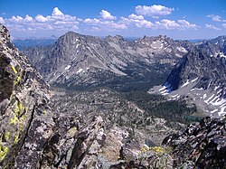
Early Yellowstone National Park Superintendent Norris claimed that the Sheepeater were the only year-round residents of Yellowstone National Park. Writer Susan Hughes doubts that the Sheepeaters could have live year-round in the park due to snow levels. She also points out to the fact that Jones expedition guide Togote, a Tukudika who is namesake of Togwotee Pass, was only familiar with the southern portion of Yellowstone Park, as evidence that Sheepeaters didn't live year-round in Yellowstone. [10]

Since Tukudika were aware migratory patterns of deer and elk and bighorn sheep, they likely migrated out of high elevations to spend winter at the mouth of mountain canyons where they spill out to the plains, or in the basins themselves. Some big game wintering areas, such as Sunlight Basin and the upper Wind River Valley, are nearly snow-free in winter. Other recent excavations have suggested that certain snow-free areas within the Wind River Range may have been used by Indians in mid-winter for up to 12,000 years. [13]

Technology

The Tukudika are known for three innovations: the steatite or soapstone cooking pot, the corral trap for hunting bighorn sheep, and the sheep horn bow.

In the Wind River Range and Absaroka Ranges of Wyoming, Tukudika used a cooking pot carved out of soft soapstone. The pot could hold up to a gallon, and be placed directly in the fire. Because of the high-specific heat of soapstone, the pot could be pulled out of the fire and maintain boiling temperatures for some time. Tukudika quarries of soap stone were found in the Wind River Range. [14]

Bighorn sheep corral traps relied on a deep understanding of bighorn sheep behavior. The Tukudika built traps in the Wind River Range and the Abaroka Range which were shaped in spirals (shaped something like a bighorn sheep horn) with the opening to the trap facing downhill. The traps were located on slopes near bighorn sheep summer range. Hunters would approach the sheep from above, then spook the animals downhill. Since sheep have an instinct to find security at high ground, the sheep would run downhill, then traverse the slope, before running uphill again. With luck, this movement of the animals would direct them straight into the mouth of a corral trap, usually constructed out of logs. The hunters would then spook the animals further into the narrowing part of the spiral trap, with the assistance of a ceremonial leader stationed in a pod along one of the corral walls. At the end of the trap, the sheep would run up a ramp into an elevated cattle-guard-like trap, with widely spaced timbers. They would fall off the timbers, with their feet hanging into air. Thus immobilized, the hunters would kill the sheep with clubs, spears, or projectiles. Some of these traps were used through the 1800s, with the remains still visible in the late 20th century. Tukudika also hunted sheep by driving them into deep drifts of spring snow. [15] [16] [17]

Shoshones in bighorn sheep habitat manufactured the sheephorn bow over a period of two to three months by boiling and straightening the spiral horn of the bighorn sheep. In geothermal areas, hot springs may have served to heat the horn. The horn would be shaped over time and backed with sinew. When completed, this bow was shorter but also much more powerful than bows made out of wood, boasting a pull strength of up to 70 pounds. Horn bows fetched a high price in trade value of five to ten horses. The bow is one of the most powerful bows created by indigenous people in North America. [18]

Notes

  1. "Shoshone-Bannock Tribes." Archived 2011-07-16 at the Wayback Machine Retrieved 24 Oct 2013.
  2. 1 2 "Shoshoni." Archived 2017-06-20 at the Wayback Machine Ethnologue. Retrieved 24 Oct 2013.
  3. 1 2 Shimkin 335
  4. 1 2 3 "Original Tribal and Band Names of Idaho's Native Peoples." Archived 2016-08-19 at the Wayback Machine Digital Atlas of Idaho. Retrieved 24 Oct 2013.
  5. 1 2 3 "History." Archived 2016-03-04 at the Wayback Machine Sawtooth National Recreation Area. Page 8. Retrieved 24 Oct 2013.
  6. Hughes, Susan S. (2000). "The Sheepeater Myth of Northwestern Wyoming". Plains Anthropologist. 45 (171). p. 6. doi:10.1080/2052546.2000.11931990. JSTOR   25669639. S2CID   159589074.
  7. "WIND RIVER SHOSHONE ETHNOGEOGRAPHY" (PDF). Archived from the original (PDF) on 2019-03-08.
  8. 1 2 Murphy and Murphy 306
  9. Murphy and Murphy 289
  10. 1 2 3 Hughes, Susan S. (2000). "The Sheepeater Myth of Northwestern Wyoming". Plains Anthropologist. 45 (171): 63–83. doi:10.1080/2052546.2000.11931990. JSTOR   25669639. S2CID   159589074.
  11. "A Tale: Trappers Encounter Peaceful Indians on the Yellowstone Plateau — Osborne Russell, 1834". 2013-05-19. Archived from the original on 2019-03-08. Retrieved 2019-03-07.
  12. Loendorf and Nabokov, pp. 174-176
  13. "Wyoming college discovers world's highest buffalo jump". November 2016. Archived from the original on 2019-10-13. Retrieved 2019-03-07.
  14. Loendorf and Nabokov, p. 154
  15. Loendorf and Nabokov, p. 171
  16. Frison, George Carr (2004). "The Rocky Mountain Sheep". Survival by Hunting: Prehistoric Human Hunters and Animal Prey. University of California Press. Chapter 6. ISBN   0-520-23190-2.
  17. Mamot, Ron (22 October 2015). "Master Engineers: A Shoshone Sheep Trap". Jackson Hole Historical Society. Archived from the original on 8 March 2019. Retrieved 7 March 2019.
  18. Loendorf and Nabokov, p. 164-167

Related Research Articles

<span class="mw-page-title-main">Crow people</span> Indigenous ethnic group in North America

The Crow, whose autonym is Apsáalooke, also spelled Absaroka, are Native Americans living primarily in southern Montana. Today, the Crow people have a federally recognized tribe, the Crow Tribe of Montana, with an Indian reservation, the Crow Indian Reservation, located in the south-central part of the state.

<span class="mw-page-title-main">Dubois, Wyoming</span> Town in Wyoming, United States

Dubois is a town in Fremont County, Wyoming, United States. The population was 971 at the 2010 census, but dropped to 911 in the 2020 census. The population nearly doubles in the summer with many part-time residents.

<span class="mw-page-title-main">Bighorn River</span> River in Wyoming and Montana, United States

The Bighorn River is a tributary of the Yellowstone, approximately 461 miles (742 km) long, in the states of Wyoming and Montana in the western United States. The river was named in 1805 by fur trader François Larocque for the bighorn sheep he saw along its banks as he explored the Yellowstone.

<span class="mw-page-title-main">Little Bighorn River</span> River in Montana and Wyoming, United States

The Little Bighorn River is a 138-mile-long (222 km) tributary of the Bighorn River in the United States in the states of Montana and Wyoming. The Battle of the Little Bighorn, also known as the Battle of the Greasy Grass, was fought on its banks on June 25–26, 1876, as well as the Battle of Crow Agency in 1887.

<span class="mw-page-title-main">Bighorn Mountains</span> Mountain range in Wyoming and Montana, United States

The Bighorn Mountains are a mountain range in northern Wyoming and southern Montana in the United States, forming a northwest-trending spur from the Rocky Mountains extending approximately 200 mi (320 km) northward on the Great Plains. They are separated from the Absaroka Range, which lie on the main branch of the Rockies to the west, by the Bighorn Basin. Much of the land is contained within the Bighorn National Forest.

<span class="mw-page-title-main">Wind River Range</span> Mountain subrange of the Rocky Mountains in Wyoming, United States

The Wind River Range is a mountain range of the Rocky Mountains in western Wyoming in the United States. The range runs roughly NW–SE for approximately 100 mi (160 km). The Continental Divide follows the crest of the range and includes Gannett Peak, which at 13,802 ft (4,207 m), is the highest peak in Wyoming; and also Fremont Peak at 13,750 ft (4,191 m), the third highest peak in Wyoming. There are more than 40 other named peaks in excess of 12,999 ft (3,962 m). With the exception of the Grand Teton in the Teton Range, the next 19 highest peaks in Wyoming after Gannett are also in the Winds.

The Shoshone or Shoshoni are a Native American tribe with four large cultural/linguistic divisions:

<span class="mw-page-title-main">Washakie</span> Eastern Shoshone chief

Washakie was a prominent leader of the Shoshone people during the mid-19th century. He was first mentioned in 1840 in the written record of the American fur trapper, Osborne Russell. In 1851, at the urging of trapper Jim Bridger, Washakie led a band of Shoshones to the council meetings of the Treaty of Fort Laramie. Essentially from that time until his death, he was considered the head of the Eastern Shoshones by the representatives of the United States government. In 1979, he was inducted into the Hall of Great Westerners of the National Cowboy & Western Heritage Museum.

<span class="mw-page-title-main">Bannock people</span> Indigenous people of North America

The Bannock tribe were originally Northern Paiute but are more culturally affiliated with the Northern Shoshone. They are in the Great Basin classification of Indigenous People. Their traditional lands include northern Nevada, southeastern Oregon, southern Idaho, and western Wyoming. Today they are enrolled in the federally recognized Shoshone-Bannock Tribes of the Fort Hall Reservation of Idaho, located on the Fort Hall Indian Reservation.

<span class="mw-page-title-main">Wind River Indian Reservation</span> Indian reservation in Wyoming, United States

The Wind River Indian Reservation, in the west-central portion of the U.S. state of Wyoming, is shared by two Native American tribes, the Eastern Shoshone and the Northern Arapaho. Roughly 60 mi (97 km) east to west by 50 mi (80 km) north to south, the Indian reservation is located in the Wind River Basin, and includes portions of the Wind River Range, Owl Creek Mountains, and Absaroka Range.

<span class="mw-page-title-main">Shoshone National Forest</span> National Forest in Wyoming, US

Shoshone National Forest is the first federally protected National Forest in the United States and covers nearly 2,500,000 acres (1,000,000 ha) in the state of Wyoming. Originally a part of the Yellowstone Timberland Reserve, the forest is managed by the United States Forest Service and was created by an act of Congress and signed into law by U.S. President Benjamin Harrison in 1891. Shoshone National Forest is one of the first nationally protected land areas anywhere. Native Americans have lived in the region for at least 10,000 years, and when the region was first explored by European adventurers, forestlands were occupied by several different tribes. Never heavily settled or exploited, the forest has retained most of its wildness. Shoshone National Forest is a part of the Greater Yellowstone Ecosystem, a nearly unbroken expanse of federally protected lands encompassing an estimated 20,000,000 acres (8,100,000 ha).

<span class="mw-page-title-main">National Elk Refuge</span>

The National Elk Refuge is a Wildlife Refuge located in Jackson Hole in the U.S. state of Wyoming. It was created in 1912 to protect habitat and provide sanctuary for one of the largest elk herds. With a total of 24,700 acres (10,000 ha), the refuge borders the town of Jackson, Wyoming on the southwest, Bridger-Teton National Forest on the east and Grand Teton National Park on the north. It is home to an average of 7,500 elk each winter. The refuge is managed by the U.S. Fish and Wildlife Service, an agency of the U.S. Department of the Interior.

<span class="mw-page-title-main">Trails of Yellowstone National Park</span>

Yellowstone National Park has over 1,100 miles (1,800 km) of blazed and mapped hiking trails, including some that have been in use for hundreds of years. Several of these trails were the sites of historical events. Yellowstone's trails are noted for various geysers, hot springs, and other geothermal features, and for viewing of bald eagles, ospreys, grizzly bears, black bears, wolves, coyotes, bighorn sheep, pronghorns, and free-ranging herds of bison and elk.

<span class="mw-page-title-main">Eastern Shoshone</span> Native American tribe in Wyoming

Eastern Shoshone are Shoshone who primarily live in Wyoming and in the northeast corner of the Great Basin where Utah, Idaho and Wyoming meet and are in the Great Basin classification of Indigenous People. They lived in the Rocky Mountains during the 1805 Lewis and Clark Expedition and adopted Plains horse culture in contrast to Western Shoshone that maintained a Great Basin culture.

<span class="mw-page-title-main">Lemhi Reservation</span>

The Lemhi Reservation was a United States Indian Reservation for the Lemhi Shoshone from 1875 to 1907. During almost all this time their main chief was Tendoy.

<span class="mw-page-title-main">Tipi ring</span> Circular patterns of stones left by historical Native Americans

Tipi rings are circular patterns of stones left from an encampment of Post-Archaic, protohistoric and historic Native Americans. They are found primarily throughout the Plains of the United States and Canada, and also in the foothills and parks of the Rocky Mountains.

The Dubois Museum is a 3,850-square-foot (358 m2) museum preserving and interpreting the history of the Upper Wind River Valley and is located in the town of Dubois, Wyoming on U.S. Route 26 along the Wyoming Centennial Scenic Byway. The museum offers interpretive programs, exhibits, multi-media presentations, and special events.

The National Bighorn Sheep Interpretive Center is a 2,775-square-foot (257.8 m2) Interpretive Center dedicated to public education about the biology and habitat of the Rocky Mountain Bighorn Sheep with specific focus on the currently largest herd of Rocky Mountain Bighorn sheep in the coterminous United States that winter in the Whisky Basin of Whisky Mountain adjacent to the Fitzpatrick Wilderness in the Shoshone National Forest. The Center preserves and interprets the relationships of the Bighorn sheep and is located in the town of Dubois, Wyoming on U.S. Route 26 along the Wyoming Centennial Scenic Byway. The museum offers interpretive programs, exhibits, multi-media presentations, and special events.

<span class="mw-page-title-main">Northern Shoshone</span> Indigenous people of North America

Northern Shoshone are Shoshone of the Snake River Plain of southern Idaho and the northeast of the Great Basin where Idaho, Wyoming and Utah meet. They are culturally affiliated with the Bannock people and are in the Great Basin classification of Indigenous People.

Black Bear was an Arapaho leader into the 1860s when the Northern Arapaho, like other Native American tribes, were prevented from ranging through their traditional hunting grounds due to settlement by European-Americans who came west during the Pike's Peak Gold Rush. Conflicts erupted over land and trails used by settlers and miners. A watershed event was the Sand Creek massacre of 1864. This led to the Northern Arapaho joining with other tribes to prevent settlement in their traditional lands. In 1865, Black Bear's village was attacked during the Battle of the Tongue River. People died, lodges were set on fire, and food was ruined, all of which made it difficult for them to survive as a unit. He died during an ambush by white settlers on April 8, 1870, in the Wild Wind Valley of present-day Wyoming.

References