Tunica, Louisiana

Last updated

Tunica, Louisiana
Tunica United Methodist Church.jpg
Tunica United Methodist Church
USA Louisiana location map.svg
Red pog.svg
Tunica, Louisiana
Location within the state of Louisiana
Coordinates: 30°55′46″N91°33′18″W / 30.92944°N 91.55500°W / 30.92944; -91.55500
Country United States
State Louisiana
Parish West Feliciana
Elevation
[1]
66 ft (20 m)
Time zone UTC-6 (Central (CST))
  Summer (DST) UTC-5 (CDT)
ZIP code
70782 [2]
GNIS feature ID556277 [1]

Tunica is an unincorporated community in West Feliciana Parish, Louisiana, United States. Its elevation is 66 feet (20 m). [1]

Contents

The United States Postal Service operates the Tunica Post Office along Louisiana Highway 66. [3]

Two sites on the National Register of Historic Places, Trudeau House and Trudeau Landing, are in Tunica.

Education

Tunica Elementary School TunicaESLouisiana.JPG
Tunica Elementary School

Residents are zoned to West Feliciana Parish Public Schools. Primary schools serving Tunica are Bains Lower Elementary School and Bains Elementary School in Bains. [4] Secondary schools serving Tunica are West Feliciana Middle School and West Feliciana High School in Bains. [5] The West Feliciana Parish Library is located in St. Francisville. [6] The library, previously a part of the Audubon Regional Library System, became independent in January 2004. [7] West Feliciana Parish is in the service area of Baton Rouge Community College. [8]

Elementary school children previously attended Tunica Elementary School. [9] The Tunica Elementary building, on Louisiana Highway 66, is 20 miles (32 km) from St. Francisville. The original school administration office and wings opened in 1953, with a third wing and multi-purpose building added at a later point. [10] The school is several miles from the main entrance of Louisiana State Penitentiary (LSP), and some of its students lived on the LSP grounds and surrounding area within the Tunica Hills area. [9] On May 18, 2011, due to budget cuts, the parish school board voted to close Tunica Elementary. [4]

Tunica Post Office TunicaPostOffice.JPG
Tunica Post Office

Related Research Articles

<span class="mw-page-title-main">West Feliciana Parish, Louisiana</span> Parish in Louisiana, United States

West Feliciana Parish is a civil parish located in the U.S. state of Louisiana. At the 2020 census, the population was 15,310. The parish seat is St. Francisville. The parish was established in 1824.

<span class="mw-page-title-main">Pointe Coupee Parish, Louisiana</span> Parish in Louisiana, United States

Pointe Coupee Parish is a parish located in the U.S. state of Louisiana. As of the 2020 census, the population was 20,758. The parish seat is New Roads.

<span class="mw-page-title-main">East Feliciana Parish, Louisiana</span> Parish in Louisiana, United States

East Feliciana Parish is a parish located in the U.S. state of Louisiana. At the 2020 census, the population was 19,531. The parish seat is Clinton.

<span class="mw-page-title-main">Jackson, Louisiana</span> Town in Louisiana, United States

Jackson is a town in East Feliciana Parish, Louisiana, United States. The population was 3,842 at the 2010 U.S. census, down from 4,130 in 2000; the 2020 population estimates program determined Jackson had a population of 3,707. It is part of the Baton Rouge metropolitan statistical area.

<span class="mw-page-title-main">Harvey, Louisiana</span> Census-designated place in Louisiana, United States

Harvey is a census-designated place (CDP) in Jefferson Parish, Louisiana, United States. Harvey is on the south side of the Mississippi River, within the New Orleans–Metairie–Kenner metropolitan statistical area. The majority-minority population was 20,348 at the 2010 census, down from 22,226 at the 2000 census. The 2020 census determined 22,236 people lived in the CDP.

Cut Off is a census-designated place (CDP) on the Bayou Lafourche in Lafourche Parish, Louisiana, United States. The population was 5,533 in 2020. It is part of the Houma–Bayou Cane–Thibodaux metropolitan statistical area. Cut Off's ZIP code is 70345, the area code is 985 and local telephone prefixes are 325, 632 and 693.

Galliano is an unincorporated community and census-designated place (CDP) on the Bayou Lafourche in Lafourche Parish, Louisiana, United States. As of 2020, its population was 7,100. It is part of the Houma–Bayou Cane–Thibodaux metropolitan statistical area.

<span class="mw-page-title-main">Larose, Louisiana</span> Census-designated place in Louisiana, United States

Larose is an unincorporated community and census-designated place (CDP) in Lafourche Parish, Louisiana, United States. The population was 6,763 in 2020. It is part of the Houma–Bayou Cane–Thibodaux metropolitan statistical area.

Mathews is a census-designated place (CDP) on Bayou Lafourche in Lafourche Parish, Louisiana, United States. The population was 2,273 in 2020. It is part of the Houma–Bayou Cane–Thibodaux metropolitan statistical area.

<span class="mw-page-title-main">Raceland, Louisiana</span> Census-designated place in Louisiana, United States

Raceland is an unincorporated community and census-designated place (CDP) on Bayou Lafourche in Lafourche Parish, Louisiana, United States. The population was 9,768 in 2020. It is part of the Houma–Bayou Cane–Thibodaux metropolitan statistical area.

<span class="mw-page-title-main">St. Francisville, Louisiana</span> Town in Louisiana, United States

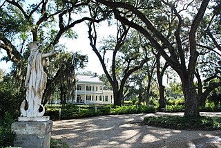
St. Francisville is a town in and the parish seat of, West Feliciana Parish, Louisiana, United States. The population was 1,557 at the 2020 census. It is part of the Baton Rouge metropolitan statistical area.

<span class="mw-page-title-main">Louisiana State Penitentiary</span> American maximum-security prison farm

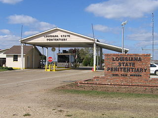
The Louisiana State Penitentiary is a maximum-security prison farm in Louisiana operated by the Louisiana Department of Public Safety & Corrections. It is named "Angola" after the former slave plantation that occupied this territory. The plantation was named after the country of Angola from which many slaves originated before arriving in Louisiana.

<span class="mw-page-title-main">Feliciana Parish, Louisiana</span> Former parish of Louisiana (1810–1824)

Feliciana Parish, or New Feliciana, French: Paroisse de Félicianne, was a parish of the Territory of Orleans and the state of Louisiana, formed in 1810 from West Florida territory. Given an increase in population, it was divided in 1824 into East Feliciana Parish and West Feliciana Parish.

Wakefield is an unincorporated community in West Feliciana Parish, Louisiana, United States. Its elevation is 246 feet.

<span class="mw-page-title-main">West Feliciana Parish Public Schools</span> School district in Louisiana, United States

West Feliciana Parish Public Schools (WFPPS) or West Feliciana Parish School Board (WFPSB) is a school district headquartered in St. Francisville, Louisiana, United States.

<span class="mw-page-title-main">Louisiana Highway 66</span> State highway in Louisiana, United States

Louisiana Highway 66 (LA 66) is a state highway located in southeastern Louisiana. It runs 19.62 miles (31.58 km) in a general east–west direction from the main entrance of the Louisiana State Penitentiary at Angola to a junction with U.S. Highway 61 (US 61) north of St. Francisville.

Bains is an unincorporated community in West Feliciana Parish, Louisiana, United States. Its elevation is 187 feet.

<span class="mw-page-title-main">St. Mary's Episcopal Church (Weyanoke, Louisiana)</span> Historic church in Louisiana, United States

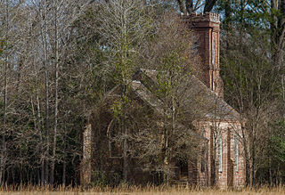
St. Mary's Episcopal Church is a historic church building in Weyanoke, Louisiana.

Weyanoke is an unincorporated community in West Feliciana Parish, Louisiana, United States. Weyanoke is located on Louisiana Highway 66, 12.2 miles (19.6 km) north-northwest of St. Francisville. Weyanoke has a post office with ZIP code 70787. Some sites that are listed on the National Register of Historic Places within Weyanoke are St. Mary's Episcopal Church and Rosebank Plantation House.

<span class="mw-page-title-main">Pitkin, Louisiana</span> CDP in Louisiana, United States

Pitkin is a census-designated place (CDP) in Vernon Parish, Louisiana, United States.

References

  1. 1 2 3 U.S. Geological Survey Geographic Names Information System: Tunica, Louisiana
  2. "Tunica ZIP Code". zipdatamaps.com. 2022. Retrieved November 11, 2022.
  3. "Post Office Location - TUNICA Archived 2012-06-16 at the Wayback Machine ." United States Postal Service. Retrieved on September 28, 2010.
  4. 1 2 Rivas, Brittany. "West Feliciana board closes elementary school Archived 2014-06-30 at the Wayback Machine ." WBRZ . May 18, 2007. Retrieved on February 18, 2012.
  5. "Schools Archived 2010-07-15 at the Wayback Machine ." West Feliciana Parish Public Schools. Retrieved on August 16, 2010.
  6. "Directory." West Feliciana Parish Library. Retrieved on September 29, 2010.
  7. "About Us." West Feliciana Parish Library. Retrieved on September 29, 2010.
  8. "Our Colleges". Louisiana's Technical and Community Colleges . Retrieved June 3, 2021.
  9. 1 2 "Fair enlivens out-of-the-way school." The Advocate . May 18, 1991. Retrieved on August 16, 2010. "Tunica Elementary is only a few miles from the main gate of the Louisiana State Penitentiary at Angola and some of its students live on the 18000 acre prison"
  10. "Our School." Tunica Elementary School. Retrieved on March 5, 2011.