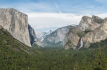
Yosemite Valley is a glacial valley in Yosemite National Park in the western Sierra Nevada mountains of Central California, United States. The valley is about 7.5 mi (12.1 km) long and 3,000–3,500 ft (910–1,070 m) deep, surrounded by high granite summits such as Half Dome and El Capitan, and densely forested with pines. The valley is drained by the Merced River, and a multitude of streams and waterfalls flow into it, including Tenaya, Illilouette, Yosemite and Bridalveil Creeks. Yosemite Falls is the highest waterfall in North America and is a big attraction, especially in the spring, when the water flow is at its peak. The valley is renowned for its natural environment and is regarded as the centerpiece of Yosemite National Park.

Wawona is a census-designated place in Mariposa County, California, United States. The population was 111 at the 2020 census.
Mariposa Grove is a sequoia grove located near Wawona, California, United States, in the southernmost part of Yosemite National Park. It is the largest grove of giant sequoias in the park, with several hundred mature specimens. Two of its trees are among the 30 largest giant sequoias in the world. The grove attracts about one million visitors annually.

Glacier Point is a viewpoint above Yosemite Valley in the U.S. state of California. It is located on the south wall of Yosemite Valley at an elevation of 7,214 feet (2,199 m), 3,200 feet (980 m) above Curry Village. The point offers a superb view of several of Yosemite National Park's well-known landmarks, including Yosemite Valley, Yosemite Falls, Half Dome, Vernal Fall, Nevada Fall, and Clouds Rest. Between 1872 and 1968, it was the site of the Yosemite Firefall.

Human habitation in the Sierra Nevada region of California reaches back 8,000 to 10,000 years ago. Historically attested Native American populations, such as the Sierra Miwok, Mono and Paiute, belong to the Uto-Aztecan and Utian phyla. In the mid-19th century, a band of Native Americans called the Ahwahnechee lived in Yosemite Valley. The California Gold Rush greatly increased the number of non-indigenous people in the region. Tensions between Native Americans and white settlers escalated into the Mariposa War. As part of this conflict, settler James Savage led the Mariposa Battalion into Yosemite Valley in 1851, in pursuit of Ahwaneechees led by Chief Tenaya. The California state military forces burned the tribe's villages, destroyed their food stores, killed the chief's sons, and forced the tribe out of Yosemite. Accounts from the Mariposa Battalion, especially from Dr. Lafayette Bunnell, popularized Yosemite Valley as a scenic wonder.

State Route 41 is a state highway in the U.S. State of California, connecting the Central Coast with the San Joaquin Valley and the Sierra Nevada. Its southern terminus is at the Cabrillo Highway in Morro Bay, and its northern terminus is at SR 140 in Yosemite National Park. It has been constructed as an expressway from near SR 198 in Lemoore north to the south part of Fresno, where the Yosemite Freeway begins, passing along the east side of downtown and extending north into Madera County.

The Wawona Hotel, located in southern Yosemite National Park, California, is a historic late Victorian mountain resort and one of the largest intact hotels of its kind within a national park. Originally established in the 1850s as Clark's Station, a pioneer stop, it soon evolved into a bustling stagecoach stop and later transformed into a grand New England–style resort, complete with manicured grounds and refined amenities. Its design catered to East Coast and European visitors, aligning with the era’s trend of exclusive grand hotels.

Badger Pass Ski Area is a small ski area located within Yosemite National Park. Badger Pass is one of only three lift serviced ski areas operating in a US National Park. It is situated five miles (8 km) south-southeast of the Chinquapin intersection of Wawona Road with Glacier Point Road in the southern area of Yosemite National Park. Glacier Point Road provides the access to this ski area. During high snow level and/or ski season, Glacier Point road terminates at Badger Pass Ski Resort. Under these conditions, the remainder of Glacier Point Road is used for cross-country skiing access to Glacier Point and other destinations in the high country.
Olmsted Point is a viewing area off Tioga Pass Road in Yosemite National Park which offers a view south into Tenaya Canyon, giving, in particular, a view of the northern side of Half Dome, Clouds Rest, and a view of Tenaya Lake to the east. The granite slopes immediately south and southwest of the parking lot feature numerous glacial erratics scattered about, as well as a short 0.125 mi (0.2 km) trail leading south - through a small grove of trees - to the top of a small granite dome where the view of Clouds Rest and Half Dome is clearest.

Taft Point is a viewpoint in Yosemite National Park west of Glacier Point. It offers wide views of Yosemite Valley, Yosemite Falls and El Capitan. The main attraction of Taft Point is the giant fissures in the mile-high granite rock. The fissures are breaks and cracks in the mountain that drop directly down to the valley floor at some points.

The Wawona Tree, also known as the Wawona Tunnel Tree, was a famous giant sequoia that stood in Mariposa Grove, Yosemite National Park, California, United States, until February 1969. It had a height of 227 feet (69 m) and was 26 feet (7.9 m) in diameter at the base.

Little Yosemite Valley is a smaller glacial valley upstream in the Merced River drainage from the Yosemite Valley in Yosemite National Park. The Merced River meanders through the 3.5 mi (5.6 km) long flat valley, draining out over Nevada Fall and Vernal Fall before emptying into the main Yosemite Valley. It can be reached by a day hike from the main valley, and is the most popular area in the Yosemite Wilderness. The Valley provides access to nearby destinations such as the back side of Half Dome, Clouds Rest and the High Sierra Camp at Merced Lake.
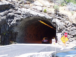
The Wawona Tunnel is a highway tunnel in Yosemite National Park. It, and Tunnel View just beyond its east portal, were completed in 1933.

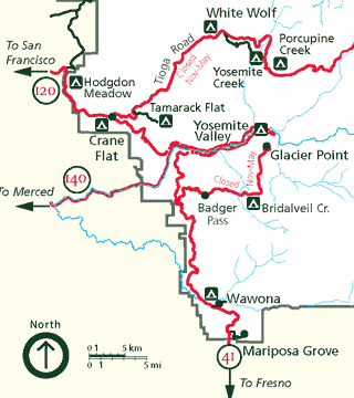
Yosemite National Park is located in the central Sierra Nevada of California. Three wilderness areas are adjacent to Yosemite: the Ansel Adams Wilderness to the southeast, the Hoover Wilderness to the northeast, and the Emigrant Wilderness to the north.
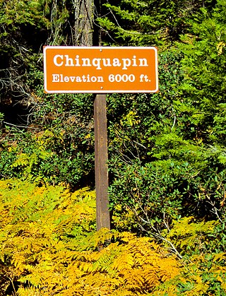
Chinquapin is a former settlement in Mariposa County, California. It was located 8.5 miles (14 km) north-northwest of Wawona. It is located within Yosemite National Park, adjacent to the community of Yosemite West. Chinquapin is the midway point between Yosemite Valley and Wawona, a community inside the park.

The Yosemite Museum is located in Yosemite Valley in Yosemite National Park in California. Founded in 1926 through the efforts of Ansel Franklin Hall, the museum's displays focus on the heritage and culture of the Ahwahnechee people who lived in the valley. The collection also includes both utilitarian and made-for-sale baskets dating from c. 1870 to present and is one of the only existing collections encompassing this depth and time span for any group in California.

Fort Monroe is a historic site in Yosemite National Park. There are no longer remnants; it is a location only. The fort was not a military fort, but started as a stage station. As various buildings were added or demolished, the general location acquired and kept the name well into the automobile age. Prior to the building of the Wawona Tunnel in 1933, the Wawona Road passed next to it, at the point where the start of Pohono Trail was located.

The Ferguson Fire was a major wildfire in the Sierra National Forest, Stanislaus National Forest and Yosemite National Park in California in the United States. The fire was reported on July 13, 2018, burning 96,901 acres (392 km2), before it was 100% contained on August 19, 2018. Interior areas of the fire continued to smolder and burn until September 19, 2018, when InciWeb declared the fire to be inactive. The Ferguson Fire was caused by the superheated fragments of a faulty vehicle catalytic converter igniting vegetation. The fire, which burned mostly in inaccessible wildland areas of the national forest, impacted recreational activities in the area, including in Yosemite National Park, where Yosemite Valley and Wawona were closed. The Ferguson Fire caused at least $171.2 million in damages, with a suppression cost of $118.5 million and economic losses measuring $52.7 million. Two firefighters were killed and nineteen others were injured in the fire.

The Panorama Trail is a marked hiking trail in Yosemite National Park that descends along the south wall of Yosemite Valley from Glacier Point, past several major waterfalls, to Happy Isles. The trail derives its name from the panoramic vistas visible along the route, most notably Panorama Point.

The Yosemite Stage and Turnpike Company, established in 1882 by Edward, John, and Henry Washburn, was a 19th-century transportation enterprise that provided stagecoach services connecting the San Joaquin Valley to Yosemite National Park. The company played a significant role in developing Yosemite's early tourism infrastructure, including the Wawona Hotel, helping to make the park more accessible to visitors.