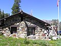
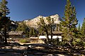
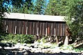
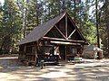
[ 3] Name on the Register [ 4] Image Date listed [ 5] Location City or town Description 1 Acting Superintendent's Headquarters Acting Superintendent's Headquarters June 9, 1978 (# 78000362 Pioneer Yosemite History Center 37°32′20″N 119°39′17″W / 37.538889°N 119.654722°W / 37.538889; -119.654722 (Acting Superintendent's Headquarters ) Wawona 2 Ahwahnee Hotel Ahwahnee Hotel February 15, 1977 (# 77000149 1 Ahwahnee Drive, Yosemite Valley 37°44′45″N 119°34′22″W / 37.745833°N 119.572778°W / 37.745833; -119.572778 (Ahwahnee Hotel ) Yosemite National Park 3 Buck Camp Patrol Cabin Buck Camp Patrol Cabin July 18, 2014 (# 14000406 Jct. of Buck Cr. & Buck Camp Tr. 37°33′47″N 119°29′23″W / 37.562991°N 119.489592°W / 37.562991; -119.489592 (Buck Camp Patrol Cabin ) Yosemite National Park 4 Camp 4 Camp 4 February 21, 2003 (# 03000056 Northside Dr., Yosemite Valley 37°44′30″N 119°36′09″W / 37.741667°N 119.6025°W / 37.741667; -119.6025 (Camp 4 ) Yosemite National Park 5 Camp Curry Historic District Camp Curry Historic District November 1, 1979 (# 79000315 Curry Village, 37°44′36″N 119°34′16″W / 37.743333°N 119.571111°W / 37.743333; -119.571111 (Camp Curry Historic District ) Yosemite National Park 6 Crane Flat Fire Lookout Crane Flat Fire Lookout April 4, 1996 (# 96000354 North of Big Oak Flat Rd., near Crane Cr., Yosemite National Park 37°45′34″N 119°49′10″W / 37.759444°N 119.819444°W / 37.759444; -119.819444 (Crane Flat Fire Lookout ) Aspen Valley part of the Historic Park Landscapes in National and State Parks Multiple Property Submission (MPS) 7 Degnan's Restaurant Degnan's Restaurant September 5, 2017 (# 100001558 9001 Village Dr., 37°44′53″N 119°35′08″W / 37.748079°N 119.585526°W / 37.748079; -119.585526 (Degnan's Restaurant ) Yosemite National Park 8 Frog Creek Cabin Frog Creek Cabin July 18, 2014 (# 14000414 South shore of Lake Eleanor , along Frog Creek 37°58′59″N 119°50′37″W / 37.983127°N 119.843480°W / 37.983127; -119.843480 (Frog Creek Cabin ) Yosemite National Park 1936-built cabin, used originally to support trout egg collection 9 Glacier Point Trailside Museum Glacier Point Trailside Museum April 4, 1978 (# 78000357 Glacier Point 37°43′50″N 119°34′23″W / 37.730556°N 119.573056°W / 37.730556; -119.573056 (Glacier Point Trailside Museum ) Yosemite National Park 10 Glen Aulin High Sierra Camp Glen Aulin High Sierra Camp July 18, 2014 (# 14000415 At confluence of Tuolumne River and Alkali Creek 37°54′32″N 119°25′08″W / 37.908812°N 119.418772°W / 37.908812; -119.418772 (Glen Aulin High Sierra Camp ) Yosemite National Park 11 Great Sierra Mine Historic Site Great Sierra Mine Historic Site May 24, 1978 (# 78000382 Southwest of Lee Vining 37°55′39″N 119°16′05″W / 37.9275°N 119.268056°W / 37.9275; -119.268056 (Great Sierra Mine Historic Site ) Yosemite National Park 12 Great Sierra Wagon Road Great Sierra Wagon Road August 25, 1978 (# 78000373 Northwest of Yosemite Valley 37°50′32″N 119°43′20″W / 37.842222°N 119.722222°W / 37.842222; -119.722222 (Great Sierra Wagon Road ) Yosemite National Park 13 Half Dome Cables and Trail Half Dome Cables and Trail August 15, 2012 (# 12000494 P.O. Box 577 37°44′49″N 119°31′47″W / 37.746863°N 119.529669°W / 37.746863; -119.529669 (Half Dome Cables and Trail ) Yosemite National Park 14 Hodgdon Homestead Cabin Hodgdon Homestead Cabin June 9, 1978 (# 78000356 Pioneer Yosemite History Center 37°32′20″N 119°39′19″W / 37.538889°N 119.655278°W / 37.538889; -119.655278 (Hodgdon Homestead Cabin ) Wawona 15 Chris Jorgensen Studio Chris Jorgensen Studio April 13, 1979 (# 79000280 Pioneer Yosemite History Center 37°32′20″N 119°39′19″W / 37.538889°N 119.655278°W / 37.538889; -119.655278 (Chris Jorgensen Studio ) Wawona 16 Lake Vernon Snow Survey Shelter Upload image July 18, 2014 (# 14000416 Terminus of Lake Vernon Tr. 38°01′10″N 119°42′55″W / 38.019422°N 119.715244°W / 38.019422; -119.715244 (Lake Vernon Snow Survey Shelter ) Yosemite National Park 17 LeConte Memorial Lodge LeConte Memorial Lodge March 8, 1977 (# 77000148 Yosemite Valley 37°44′24″N 119°34′42″W / 37.74°N 119.578333°W / 37.74; -119.578333 (LeConte Memorial Lodge ) Yosemite National Park 18 Mariposa Grove Museum Mariposa Grove Museum December 1, 1978 (# 78000381 Southeast of Wawona 37°30′50″N 119°35′54″W / 37.513889°N 119.598333°W / 37.513889; -119.598333 (Mariposa Grove Museum ) Yosemite National Park 19 May Lake High Sierra Camp Upload image July 18, 2014 (# 14000417 Eastern shore of May Lake 37°50′42″N 119°29′28″W / 37.844924°N 119.490996°W / 37.844924; -119.490996 (May Lake High Sierra Camp ) Yosemite National Park 20 McCauley Cabin McCauley Cabin March 8, 1977 (# 77000359 Tuolumne Meadows 37°52′40″N 119°22′01″W / 37.877778°N 119.366944°W / 37.877778; -119.366944 (McCauley Cabin ) Yosemite National Park 21 McCauley and Meyer Barns McCauley and Meyer Barns June 15, 1978 (# 78000353 North of El Portal 37°42′00″N 119°45′18″W / 37.7°N 119.755°W / 37.7; -119.755 (McCauley and Meyer Barns ) Yosemite National Park 22 McGurk Cabin McGurk Cabin June 4, 1979 (# 79000281 South of Yosemite Valley 37°40′40″N 119°37′27″W / 37.677778°N 119.624167°W / 37.677778; -119.624167 (McGurk Cabin ) Yosemite National Park 23 Merced Grove Ranger Station Merced Grove Ranger Station June 15, 1978 (# 78000358 North of El Portal 37°44′56″N 119°50′21″W / 37.748889°N 119.839167°W / 37.748889; -119.839167 (Merced Grove Ranger Station ) Yosemite National Park 24 Merced Lake High Sierra Camp Upload image July 18, 2014 (# 14000407 Along north bank of Merced River, directly east of Merced Lake 37°44′24″N 119°24′24″W / 37.739928°N 119.406544°W / 37.739928; -119.406544 (Merced Lake High Sierra Camp ) Yosemite National Park 25 Merced Lake Ranger Station Upload image July 18, 2014 (# 14000408 Jct. of Merced Lake Tr. & Lewis Cr. 37°44′18″N 119°23′45″W / 37.738261°N 119.395709°W / 37.738261; -119.395709 (Merced Lake Ranger Station ) Yosemite National Park 26 Ostrander Lake Ski Hut Ostrander Lake Ski Hut July 18, 2014 (# 14000409 Ostrander Lake Tr. 37°37′36″N 119°32′59″W / 37.626778°N 119.549753°W / 37.626778; -119.549753 (Ostrander Lake Ski Hut ) Yosemite National Park 27 Parsons Memorial Lodge Parsons Memorial Lodge April 30, 1979 (# 79000283 Tuolumne Meadows 37°52′42″N 119°22′00″W / 37.878333°N 119.366667°W / 37.878333; -119.366667 (Parsons Memorial Lodge ) Yosemite National Park 28 Rangers' Club Rangers' Club May 28, 1987 (# 87001414 Yosemite Village 37°44′50″N 119°35′12″W / 37.747222°N 119.586667°W / 37.747222; -119.586667 (Rangers' Club ) Yosemite National Park 29 Sachse Spring Snow Survey Shelter Upload image July 18, 2014 (# 14000418 Off Kibbie Ridge Tr. near Sachse Spring 38°04′51″N 119°50′34″W / 38.080825°N 119.842905°W / 38.080825; -119.842905 (Sachse Spring Snow Survey Shelter ) Yosemite National Park 30 Snow Creek Ski Hut Upload image July 18, 2014 (# 14000410 Off Tenaya Lake Trail, westerly shoulder of Mt. Watkins 37°47′17″N 119°31′22″W / 37.787980°N 119.522663°W / 37.787980; -119.522663 (Snow Creek Ski Hut ) Yosemite National Park 31 Snow Flat Snow Survey Shelter Upload image July 18, 2014 (# 14000411 Terminus of service road off May Lake Rd. 37°49′31″N 119°29′52″W / 37.825332°N 119.497667°W / 37.825332; -119.497667 (Snow Flat Snow Survey Shelter ) Yosemite National Park 32 Soda Springs Cabin Soda Springs Cabin April 19, 1979 (# 79000282 Tuolumne Meadows 37°52′44″N 119°21′56″W / 37.878889°N 119.365556°W / 37.878889; -119.365556 (Soda Springs Cabin ) Yosemite National Park 33 Sunrise High Sierra Camp Upload image July 18, 2014 (# 14000412 Along north bank of Long Meadow Creek, overlooking Long Meadow (southeast of Sunrise Lakes) 37°47′43″N 119°25′58″W / 37.795203°N 119.432658°W / 37.795203; -119.432658 (Sunrise High Sierra Camp ) Yosemite National Park 34 Tioga Pass Entrance Station Tioga Pass Entrance Station December 14, 1978 (# 78000372 Southwest of Lee Vining 37°54′39″N 119°15′27″W / 37.910833°N 119.2575°W / 37.910833; -119.2575 (Tioga Pass Entrance Station ) Yosemite National Park 35 Tuolumne Meadows Upload image November 30, 1978 (# 78000371 Southwest of Lee Vining 37°52′17″N 119°22′20″W / 37.871389°N 119.372222°W / 37.871389; -119.372222 (Tuolumne Meadows ) Yosemite National Park Listing is for CCC camp structures in the meadow area 36 Tuolumne Meadows High Sierra Camp Tuolumne Meadows High Sierra Camp July 18, 2014 (# 14000419 Along north bank of Dana Fork of Tuolumne River, east of Tuolumne Meadows 37°52′39″N 119°19′58″W / 37.877426°N 119.332655°W / 37.877426; -119.332655 (Tuolumne Meadows High Sierra Camp ) Yosemite National Park 37 Tuolumne Meadows Ranger Stations and Comfort Stations Tuolumne Meadows Ranger Stations and Comfort Stations December 18, 1978 (# 78000370 Tuolumne Meadows 37°52′24″N 119°21′16″W / 37.873333°N 119.354444°W / 37.873333; -119.354444 (Tuolumne Meadows Ranger Stations and Comfort Stations ) Yosemite National Park 38 Vogelsang High Sierra Camp Vogelsang High Sierra Camp July 18, 2014 (# 14000413 Along Fletcher Creek, immediately southwest of Fletcher Lake 37°47′43″N 119°20′44″W / 37.795205°N 119.345431°W / 37.795205; -119.345431 (Vogelsang High Sierra Camp ) Yosemite National Park 39 Wawona Covered Bridge Wawona Covered Bridge January 11, 2007 (# 06001261 Pioneer Yosemite History Center 37°32′19″N 119°39′17″W / 37.538611°N 119.654722°W / 37.538611; -119.654722 (Wawona Covered Bridge ) Wawona 40 Wawona Hotel and Pavilion Wawona Hotel and Pavilion October 1, 1975 (# 75000223 On CA 41 in Yosemite National Park 37°32′11″N 119°39′13″W / 37.536389°N 119.653611°W / 37.536389; -119.653611 (Wawona Hotel and Pavilion ) Wawona 41 Yosemite Transportation Company Office Yosemite Transportation Company Office June 9, 1978 (# 78000355 Pioneer Yosemite History Center 37°32′20″N 119°39′17″W / 37.538889°N 119.654722°W / 37.538889; -119.654722 (Yosemite Transportation Company Office ) Wawona 42 Yosemite Valley Yosemite Valley December 14, 2006 (# 04001159 Yosemite National Park 37°43′43″N 119°36′07″W / 37.728611°N 119.601944°W / 37.728611; -119.601944 (Yosemite Valley ) Yosemite National Park 43 Yosemite Valley Archeological District Upload image January 20, 1978 (# 78000361 Address Restricted Yosemite National Park 44 Yosemite Valley Bridges Yosemite Valley Bridges November 25, 1977 (# 77000160 8 bridges over Merced River, Yosemite Valley 37°43′58″N 119°36′00″W / 37.732778°N 119.6°W / 37.732778; -119.6 (Yosemite Valley Bridges ) Yosemite National Park 45 Yosemite Valley Chapel Yosemite Valley Chapel December 12, 1973 (# 73000256 Off CA 140 in Yosemite Valley 37°44′27″N 119°35′26″W / 37.740833°N 119.590556°W / 37.740833; -119.590556 (Yosemite Valley Chapel ) Yosemite National Park 46 Yosemite Village Historic District Yosemite Village Historic District March 30, 1978 (# 78000354 Yosemite Village 37°44′55″N 119°35′18″W / 37.748611°N 119.588333°W / 37.748611; -119.588333 (Yosemite Village Historic District ) Yosemite National Park