The Calder and Hebble Navigation is a broad inland waterway, with locks and bridgeholes that are suitable for 14-foot-wide (4.3 m) boats, in West Yorkshire, England. Construction to improve the River Calder and the River Hebble began in 1759, and the initial scheme, which included 5.7 miles (9.2 km) of new cuts, was completed in 1770 and has remained navigable since it was opened. Significant improvements were made, including the Salterhebble branch to Halifax, opened in 1828, and ever-longer cuts to bypass river sections. Trade was assisted by the opening of the Rochdale Canal in 1804, which provided a through route from Sowerby Bridge to Manchester. There were plans to abandon the river sections completely in the 1830s, but these were modified as the needs of mill owners and other riparian landowners were recognised.

Huddersfield is a market town in the Metropolitan Borough of Kirklees, West Yorkshire, England. Huddersfield was a prominent mill town in the industrial revolution. To the town's west are the Pennines, south is the River Holme's discharge into the similar-sized Colne. The town's historic county is the West Riding of Yorkshire.

The M62 is a 107-mile-long (172 km) west–east trans-Pennine motorway in Northern England, connecting Liverpool and Hull via Manchester, Bradford, Leeds and Wakefield; 7 miles (11 km) of the route is shared with the M60 orbital motorway around Manchester. The road is part of the unsigned Euroroutes E20 and E22.
The Ashton Canal is a canal in Greater Manchester, England, linking Manchester with Ashton-under-Lyne.

The Duluth MN-WI Metropolitan Area, commonly called the Twin Ports, is a small metropolitan area centered around the cities of Duluth, Minnesota and Superior, Wisconsin. The Twin Ports are located at the western part of Lake Superior and together are considered one of the larger cargo ports in the United States. The Twin Ports are close to many natural attractions such as the North Shore, the Apostle Islands, and the Superior National Forest.

The Huddersfield Narrow Canal is an inland waterway in northern England. It runs just under 20 miles (32 km) from Lock 1E at the rear of the University of Huddersfield campus, near Aspley Basin in Huddersfield, to the junction with the Ashton Canal at Whitelands Basin in Ashton-under-Lyne. It crosses the Pennines by means of 74 locks and the Standedge Tunnel.

The Huddersfield Broad Canal or Sir John Ramsden's Canal, is a wide-locked navigable canal in West Yorkshire in northern England. The waterway is 3.75 miles (6 km) long and has 9 wide locks. It follows the valley of the River Colne and connects the Calder and Hebble Navigation at Cooper Bridge junction with the Huddersfield Narrow Canal near Aspley Basin in Huddersfield.

The Colne Valley is a steep sided valley on the east flank of the Pennine Hills in the English county of West Yorkshire. It takes its name from the River Colne which rises above the town of Marsden and flows eastward towards Huddersfield.

Navigable aqueducts are bridge structures that carry navigable waterway canals over other rivers, valleys, railways or roads. They are primarily distinguished by their size, carrying a larger cross-section of water than most water-supply aqueducts. Roman aqueducts were used to transport water and were created in Ancient Rome. The 662-metre (2,172 ft) long steel Briare aqueduct carrying the Canal latéral à la Loire over the River Loire was built in 1896. It was ranked as the longest navigable aqueduct in the world for more than a century, until the Magdeburg Water Bridge in Germany took the title in the early 21st century.

Marsden railway station serves the village of Marsden near Huddersfield in West Yorkshire, England. The station is on the Huddersfield Line, operated by Northern and is about 7 miles (11 km) west of Huddersfield station. It was opened in 1849 by the London & North Western Railway and is the last station before the West Yorkshire boundary with Greater Manchester.
Longroyd Bridge is a suburb approximately 1200 yds (1.1 km) to the southwest of Huddersfield town centre, West Yorkshire, England. The area is composed of industrial and commercial units. There is little housing in the commercial area, though within a few hundred yards are the housing areas of Thornton Lodge and Paddock.
Aspley is an area adjacent to the ring road around Huddersfield, Kirklees, West Yorkshire, England. It comprises a mixture of independent shops, commercial units, a small retail park, houses, student accommodation and sections of the University of Huddersfield and Kirklees Council offices, pubs and fast food outlets. It is known locally as Aspley Wharf.
Standedge is a moorland escarpment in the Pennine Hills of northern England between Marsden, West Yorkshire and Diggle, Greater Manchester. Standedge has been a major moorland crossing point since Roman times and possibly earlier.

The South Pennines is a region of moorland and hill country in northern England lying towards the southern end of the Pennines. In the west it includes the Rossendale Valley and the West Pennine Moors. It is bounded by the Greater Manchester conurbation in the west and the Bowland Fells and Yorkshire Dales to the north. To the east it is fringed by the towns of West Yorkshire whilst to the south it is bounded by the Peak District. The rural South Pennine Moors constitutes both a Site of Special Scientific Interest and Special Area of Conservation.

The South Pennine Ring is an English canal ring which crosses the Pennines between Manchester and Huddersfield. It covers parts of five canals, and includes passage through the longest canal tunnel in Britain. It has only been possible to cruise it since 2002, when restoration of the Huddersfield Narrow Canal provided the return route across the Pennines.
Dukinfield Junction is the name of the canal junction where the Peak Forest Canal, the Ashton Canal and the Huddersfield Narrow Canal meet near Ashton-under-Lyne, Greater Manchester, England. The area has been designated by Tameside Metropolitan Borough Council as a conservation area.
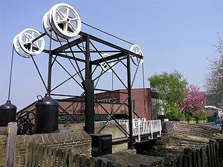
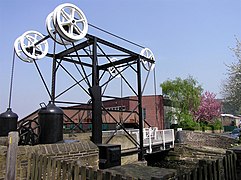
The Turnbridge Lift Bridge is a lift bridge which spans the Huddersfield Broad Canal at Turnbridge, Kirklees, West Yorkshire, England. Officially known as Turnbridge, it is bridge number 17 on the Huddersfield Broad Canal.

The River Calder is a river in West Yorkshire, in Northern England.
Newsome is a ward of Huddersfield in the metropolitan borough of Kirklees, West Yorkshire, England. It contains over 430 listed buildings that are recorded in the National Heritage List for England. Of these, one is listed at Grade I, the highest of the three grades, 16 are at Grade II*, the middle grade, and the others are at Grade II, the lowest grade. The ward is large, and contains the centre of the town of Huddersfield, and areas to the west and south. This list contains the listed buildings outside the centre of the town, namely those outside the ring road, and include the areas of Almondbury, Armitage Bridge, Aspley, Highfields, Lockwood, Longley, Lowerhouses, Moldgreen, Newsome, Rashcliffe, Springwood, and Taylor Hill. The listed buildings in the central area within the ring road are at Listed buildings in Huddersfield
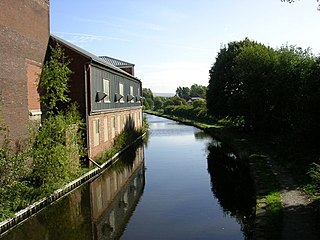
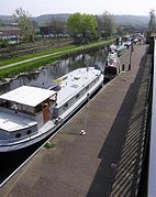 Turnbridge Section of Huddersfield Broad Canal