
Michigan is a state in the Great Lakes region of the upper Midwestern United States. Its name derives from a gallicized variant of the original Ojibwe word ᒥᓯᑲᒥ, meaning 'large water' or 'large lake'. With a population of nearly 10.12 million and a total area of nearly 97,000 sq mi (250,000 km2), Michigan is the 10th-largest state by population, the 11th-largest by area, and the largest by area east of the Mississippi River. Its capital is Lansing, and its largest city is Detroit. Metro Detroit is among the nation's most populous and largest metropolitan economies.

Lake Huron is one of the five Great Lakes of North America. Hydrologically, it comprises the easterly portion of Lake Michigan–Huron, having the same surface elevation as Lake Michigan, to which it is connected by the 5-mile-wide (8.0 km), 20-fathom-deep Straits of Mackinac. It is shared on the north and east by the Canadian province of Ontario and on the south and west by the U.S. state of Michigan. The name of the lake is derived from early French explorers who named it for the Huron people inhabiting the region.

Wayne County is the most populous county in the U.S. state of Michigan. As of 2020, the United States Census placed its population at 1,793,561 making it the 19th-most populous county in the United States. The county seat is Detroit. The county was founded in 1796 and organized in 1815. Wayne County is included in the Detroit-Warren-Dearborn, MI Metropolitan Statistical Area. It is one of several U.S. counties named after Revolutionary War-era general Anthony Wayne.

Huron County is a county in the U.S. state of Michigan. As of the 2020 Census, the population was 31,407. The county seat is Bad Axe. Huron County is at the northern tip of the Thumb, which is a sub region of Mid Michigan. It is a peninsula, bordered by Saginaw Bay to the west and Lake Huron to the north and east, and has over 90 miles (140 km) of shoreline, from White Rock on Lake Huron to Sebewaing on the Saginaw Bay. Huron County's most important industry is agriculture, as with most of the other Thumb counties. Huron County enjoys seasonal tourism from large cities such as Detroit, Flint, and Saginaw. A lot of the tourism is in the Port Austin and Caseville area.
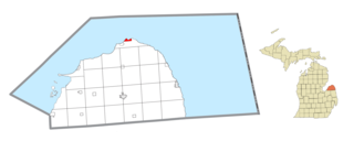
Pointe Aux Barques Township is a civil township of Huron County in the U.S. state of Michigan. The population was 15 at the 2020 census.
The Thumb is a region and a peninsula of the U.S. state of Michigan, so named because the Lower Peninsula is shaped like a mitten. The Thumb area is generally considered to be in the Central Michigan region, east of the Tri-Cities and north of Metro Detroit. The region is also branded as the Blue Water Area.

Central Michigan, also called Mid Michigan, is a region in the Lower Peninsula of the U.S. state of Michigan. As its name implies, it is the middle area of the Lower Peninsula. Lower Michigan is said to resemble a mitten, and Mid Michigan corresponds roughly to the thumb and palm, stretching from Michigan's eastern shoreline along Lake Huron into the fertile rolling plains of the Michigan Basin. The region contains cities of moderate size, including Flint, Saginaw, and the state capital of Lansing.
Interstate 94 (I-94) is a part of the Interstate Highway System that runs from Billings, Montana, to the Lower Peninsula of the US state of Michigan. In Michigan, it is a state trunkline highway that enters the state south of New Buffalo and runs eastward through several metropolitan areas in the southern section of the state. The highway serves Benton Harbor–St. Joseph near Lake Michigan before turning inland toward Kalamazoo and Battle Creek on the west side of the peninsula. Heading farther east, I-94 passes through rural areas in the middle of the southern Lower Peninsula, crossing I-69 in the process. I-94 then runs through Jackson, Ann Arbor, and portions of Metro Detroit, connecting Michigan's largest city to its main airport. Past the east side of Detroit, the Interstate angles northeasterly through farmlands in The Thumb to Port Huron, where the designation terminates on the Blue Water Bridge at the Canadian border.

SS Daniel J. Morrell was a 603-foot (184 m) Great Lakes freighter that broke up in a strong storm on Lake Huron on 29 November 1966, taking with her 28 of her 29 crewmen. The freighter was used to carry bulk cargoes such as iron ore but was running with only ballast when the 60-year-old ship sank.
Port Sanilac Light is a United States Coast Guard lighthouse located on Point Sanilac, near Port Sanilac on the eastern side of Michigan's Thumb. It is an automated and active aid to navigation on Lake Huron.
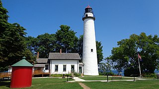
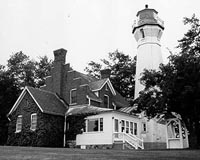
Pointe aux Barques Lighthouse is an active lighthouse located in Huron County in the U.S. state of Michigan. It is located along the shores of Lake Huron on the northeastern tip of the Thumb. Originally constructed in 1848, it is one of the oldest active lighthouses in the state. The name is translated as "point of little boats" from the French language, which refers to the shallow coastline that poses a threat to larger boats.

Michigan consists of two peninsulas surrounded primarily by four of the Great Lakes and a variety of nearby islands. The Upper Peninsula is bounded on the southwest by Wisconsin, and the Lower Peninsula is bounded on the south by Indiana and Ohio. Both land masses are also separated from the Canadian province of Ontario by waterways of the Great Lakes, and from each other by the Straits of Mackinac. Because its land is largely surrounded by the Great Lakes, which flow into the Saint Lawrence River, Michigan is the only U.S. state whose streams and rivers are almost entirely within the Great Lakes-St. Lawrence watershed.
US Highway 25 (US 25) was a part of the United States Numbered Highway System in the state of Michigan that ran from the Ohio state line near Toledo and ended at the tip of The Thumb in Port Austin. The general routing of this state trunkline highway took it northeasterly from the state line through Monroe and Detroit to Port Huron. Along this southern half, it followed undivided highways and ran concurrently along two freeways, Interstate 75 (I-75) and I-94. Near the foot of the Blue Water Bridge in Port Huron, US 25 turned north and northwesterly along the Lake Huron shoreline to Port Austin.

Pointe Mouillee State Game Area is a state game area in the U.S. state of Michigan. It encompasses 7,483 acres (30.3 km2) of hunting, recreational, and protected wildlife and wetland areas at the mouth of the Huron River at Lake Erie, as well as smaller outlying areas within the Detroit River. Pointe Mouillee State Game Area was established in 1945 and is administered by the Michigan Department of Natural Resources.
The Thumb Area Underwater Preserve is a preservation area in Lake Huron in the U.S. state of Michigan. It is 276 square miles (710 km2) in size and is located off Michigan's Thumb north of Detroit.

The SS Hydrus was an American steel-hulled Great Lakes bulk freighter, constructed in 1903 and launched as the R.E. Schuck. She was following the SS James Carruthers heading south on Lake Huron while carrying a load of iron ore when she and the Carruthers were caught in the Great Lakes Storm of 1913.
The 1952 Michigan State Normal Hurons football team represented Michigan State Normal College in the Interstate Intercollegiate Athletic Conference (IIAC) during the 1952 college football season. In their first season under head coach Fred Trosko, the Hurons compiled a 5–3–1 record, finished in third place in the IIAC, and outscored their opponents, 154 to 146. The team was rated as the best team fielded by the school since 1945.
John S. Heath (1807–1849) was an American physician and politician who served two terms in the Michigan House of Representatives.

PS Keystone State was a wooden-hulled American paddle steamer in service between 1849 and 1861. She was built in 1848 in Buffalo, New York, by Bidwell & Banta for ship-owner Charles M. Reed of Erie, Pennsylvania, and operated as part of his "Chicago Line". A luxuriously furnished palace steamer, she operated between Buffalo and Chicago, Illinois, while also making stops at various other ports. She was built for the passenger and package freight trade, frequently carrying both wealthy passengers and European immigrants who desired to settle in the Midwestern United States. Due to the Panic of 1857, Keystone State and several other paddle steamers were laid up. When the American Civil War began in 1861, she was refurbished, and put back into service.
