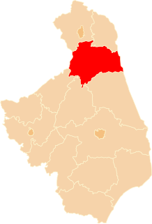
Czarnucha is a village in the administrative district of Gmina Augustów, within Augustów County, Podlaskie Voivodeship, in north-eastern Poland. It lies approximately 7 kilometres (4 mi) south-east of Augustów and 79 km (49 mi) north of the regional capital Białystok.
Góry is a village in the administrative district of Gmina Augustów, within Augustów County, Podlaskie Voivodeship, in north-eastern Poland. It lies approximately 7 kilometres (4 mi) south-east of Augustów and 77 km (48 mi) north of the regional capital Białystok.
Komaszówka is a village in the administrative district of Gmina Augustów, within Augustów County, Podlaskie Voivodeship, in north-eastern Poland. It lies approximately 12 kilometres (7 mi) south of Augustów and 72 km (45 mi) north of the regional capital Białystok.
Netta-Folwark is a village in the administrative district of Gmina Augustów, within Augustów County, Podlaskie Voivodeship, in north-eastern Poland. It lies approximately 12 kilometres (7 mi) south-west of Augustów and 74 km (46 mi) north of the regional capital Białystok.
Ponizie is a village in the administrative district of Gmina Augustów, within Augustów County, Podlaskie Voivodeship, in northeastern Poland. It lies approximately 7 kilometres (4 mi) south-east of Augustów and 77 km (48 mi) north of the regional capital Białystok.
Promiski is a village in the administrative district of Gmina Augustów, within Augustów County, Podlaskie Voivodeship, in north-eastern Poland. It lies approximately 12 kilometres (7 mi) south of Augustów and 72 km (45 mi) north of the regional capital Białystok.
Rzepiski is a village in the administrative district of Gmina Augustów, within Augustów County, Podlaskie Voivodeship, in north-eastern Poland. It lies approximately 8 kilometres (5 mi) south-east of Augustów and 77 km (48 mi) north of the regional capital Białystok.
Reszki is a village in the administrative district of Gmina Bargłów Kościelny, within Augustów County, Podlaskie Voivodeship, in north-eastern Poland. It lies approximately 9 kilometres (6 mi) north-west of Bargłów Kościelny, 15 km (9 mi) west of Augustów, and 85 km (53 mi) north of the regional capital Białystok.
Dulkowszczyzna is a village in the administrative district of Gmina Lipsk, within Augustów County, Podlaskie Voivodeship, in north-eastern Poland, close to the border with Belarus. It lies approximately 6 kilometres (4 mi) east of Lipsk, 36 km (22 mi) east of Augustów, and 74 km (46 mi) north of the regional capital Białystok.
Kurianka is a village in the administrative district of Gmina Lipsk, within Augustów County, Podlaskie Voivodeship, in north-eastern Poland, close to the border with Belarus. It lies approximately 5 kilometres (3 mi) north-east of Lipsk, 35 km (22 mi) east of Augustów, and 74 km (46 mi) north of the regional capital Białystok.
Rygałówka is a village in the administrative district of Gmina Lipsk, within Augustów County, Podlaskie Voivodeship, in north-eastern Poland, close to the border with Belarus. It lies approximately 10 kilometres (6 mi) east of Lipsk, 41 km (25 mi) east of Augustów, and 73 km (45 mi) north of the regional capital Białystok.
Siółko is a village in the administrative district of Gmina Lipsk, within Augustów County, Podlaskie Voivodeship, in north-eastern Poland, close to the border with Belarus. It lies approximately 9 kilometres (6 mi) east of Lipsk, 40 km (25 mi) east of Augustów, and 73 km (45 mi) north of the regional capital Białystok.
Lipiny is a settlement in the administrative district of Gmina Płaska, within Augustów County, Podlaskie Voivodeship, in north-eastern Poland, close to the border with Belarus. It lies approximately 18 kilometres (11 mi) east of Płaska, 36 km (22 mi) east of Augustów, and 88 km (55 mi) north of the regional capital Białystok.
Długie is a village in the administrative district of Gmina Sztabin, within Augustów County, Podlaskie Voivodeship, in north-eastern Poland. It lies approximately 9 kilometres (6 mi) north of Sztabin, 16 km (10 mi) south-east of Augustów, and 71 km (44 mi) north of the regional capital Białystok.
Kryłatka is a village in the administrative district of Gmina Sztabin, within Augustów County, Podlaskie Voivodeship, in north-eastern Poland. It lies approximately 8 kilometres (5 mi) north of Sztabin, 16 km (10 mi) south-east of Augustów, and 70 km (43 mi) north of the regional capital Białystok.
Grzybowszczyzna is a village in the administrative district of Gmina Szudziałowo, within Sokółka County, Podlaskie Voivodeship, in north-eastern Poland, close to the border with Belarus.
Baldram is a village in the administrative district of Gmina Kwidzyn, within Kwidzyn County, Pomeranian Voivodeship, in northern Poland. It lies approximately 3 kilometres (2 mi) north of Kwidzyn and 71 km (44 mi) south of the regional capital Gdańsk.
Smarzewo is a village in the administrative district of Gmina Smętowo Graniczne, within Starogard County, Pomeranian Voivodeship, in northern Poland. It lies approximately 2 kilometres (1 mi) north-east of Smętowo Graniczne, 26 km (16 mi) south-east of Starogard Gdański, and 68 km (42 mi) south of the regional capital Gdańsk.
Gaudynki is a village in the administrative district of Gmina Orzysz, within Pisz County, Warmian-Masurian Voivodeship, in northern Poland. It lies approximately 7 kilometres (4 mi) south-west of Orzysz, 17 km (11 mi) north of Pisz, and 91 km (57 mi) east of the regional capital Olsztyn.
Cieszeniewo is a village in the administrative district of Gmina Świdwin, within Świdwin County, West Pomeranian Voivodeship, in north-western Poland. It lies approximately 10 kilometres (6 mi) east of Świdwin and 96 km (60 mi) north-east of the regional capital Szczecin.